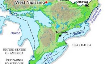
Chapleau, Ont, incorporated as a township of Sudbury District in 1901, population 2116 (2011c), 2354 (2006c). The Township of Chapleau is located on the Kebsquasheshing River (also known as the Chapleau River) in northeastern Ontario, 272 km northwest of GREATER SUDBURY. A divisional point on the CANADIAN PACIFIC RAILWAY (CPR), the community was named after Sir Joseph-Adolphe CHAPLEAU, the secretary of state in the Conservative government of Sir John A. Macdonald during the railway's construction in the 1880s. Over a century before, in 1777, the HUDSON'S BAY CO had established the first of a series of fur-trading posts in the area, which served the native Cree and Ojibwa populations until World War I.
Since its inception in 1885, Chapleau has acted as a home terminal for the CPR, as well as a distribution and administrative centre for mining, lumbering and pulpwood operations, Native affairs and provincial government forest management activities in the region. The nearby Chapleau Crown Game Preserve (established in 1925, area 7000 km2) is one of the largest game preserves in the world.

 Share on Facebook
 Share on X
 Share by Email
 Share on Google Classroom


