List
30 "Only in Canada" Place Names
To celebrate its 30th anniversary, The Canadian Encyclopedia created 30 lists of 30 things that make us proud to be Canadian, from famous people and historic events, to iconic foods and influential artists.
Signing up enhances your TCE experience with the ability to save items to your personal reading list, and access the interactive map.
Create AccountList
To celebrate its 30th anniversary, The Canadian Encyclopedia created 30 lists of 30 things that make us proud to be Canadian, from famous people and historic events, to iconic foods and influential artists.
"https://d3d0lqu00lnqvz.cloudfront.net/media/media/a7c708ef-3e7b-4890-a1ad-f637397985a6.jpg" // resources/views/front/categories/view.blade.phphttps://d3d0lqu00lnqvz.cloudfront.net/media/media/a7c708ef-3e7b-4890-a1ad-f637397985a6.jpg

Article
Aklavik, NWT, incorporated as a hamlet in 1974, population 633 (2011c), 594 (2006c). The Hamlet of Aklavik is located near the mouth of the Mackenzie River, 1143 air km northwest of Yellowknife.
"https://www.thecanadianencyclopedia.ca/images/tce_placeholder.jpg?v=e9dca980c9bdb3aa11e832e7ea94f5d9" // resources/views/front/categories/view.blade.phphttps://www.thecanadianencyclopedia.ca/images/tce_placeholder.jpg?v=e9dca980c9bdb3aa11e832e7ea94f5d9

Article
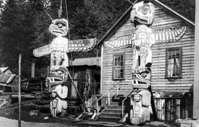
Alert Bay, BC, incorporated as a village in 1946, population 445 (2011c), 456 (2006c). The Village of Alert Bay is located on Cormorant Island, off Vancouver Island, 288 km north of Vancouver.
"https://d3d0lqu00lnqvz.cloudfront.net/media/media/691936c7-8d2d-4aad-9409-ab3bda1de214.jpg" // resources/views/front/categories/view.blade.phphttps://d3d0lqu00lnqvz.cloudfront.net/media/media/691936c7-8d2d-4aad-9409-ab3bda1de214.jpg
Article
Ashcroft, BC, incorporated as a village in 1952, population 1628 (2011c), 1664 (2006c). The Village of Ashcroft is situated on a flat bench above the Thompson River in the dry belt of the interior of southern British Columbia, about 90 km west of Kamloops.
"https://www.thecanadianencyclopedia.ca/images/tce_placeholder.jpg?v=e9dca980c9bdb3aa11e832e7ea94f5d9" // resources/views/front/categories/view.blade.phphttps://www.thecanadianencyclopedia.ca/images/tce_placeholder.jpg?v=e9dca980c9bdb3aa11e832e7ea94f5d9
Article
Atlin, BC, Unincorporated Place, elevation 671 m. Atlin is a small community of about 400 residents situated on Atlin Lake in the lake district of the northwest corner of the province, 182 kilometres southeast of Whitehorse, Yukon.
"https://www.thecanadianencyclopedia.ca/images/tce_placeholder.jpg?v=e9dca980c9bdb3aa11e832e7ea94f5d9" // resources/views/front/categories/view.blade.phphttps://www.thecanadianencyclopedia.ca/images/tce_placeholder.jpg?v=e9dca980c9bdb3aa11e832e7ea94f5d9
Article
Baddeck, NS, incorporated as a village in 1950, population 769 (2011c), 873 (2006c). The Village of Baddeck is located on the north shore of Bras d'Or Lake, 60 km west of North Sydney.
"https://d3d0lqu00lnqvz.cloudfront.net/media/media/29987043-6718-49ef-af1b-7073898c2060.jpg" // resources/views/front/categories/view.blade.phphttps://d3d0lqu00lnqvz.cloudfront.net/media/media/29987043-6718-49ef-af1b-7073898c2060.jpg

Article
Baker Lake (a.k.a. Qamani’tuaq), Nunavut, incorporated as a hamlet in 1977, population 2,069 (2016 census), 1,872 (2011 census). The hamlet of Baker Lake is located at the northwest end of Baker Lake, about 280 km west of the mouth of Chesterfield Inlet on Hudson Bay. The community is approximately at the geographic centre of Canada. Baker Lake is the only inland Inuit community in Nunavut.
"https://d3d0lqu00lnqvz.cloudfront.net/media/media/40755f53-7867-4e0b-a59c-1efb9df6e171.jpg" // resources/views/front/categories/view.blade.phphttps://d3d0lqu00lnqvz.cloudfront.net/media/media/40755f53-7867-4e0b-a59c-1efb9df6e171.jpg

Article
Sheriff Alexander C. Macdonell, Selkirk's agent, struggled for years at considerable expense to the earl to make a success of the venture, but found the swampy land and the difficulty of sheep farming to be serious obstacles.
"https://d3d0lqu00lnqvz.cloudfront.net/media/media/0c582e2e-b609-41c2-b9dc-50071198f9c4.jpg" // resources/views/front/categories/view.blade.phphttps://d3d0lqu00lnqvz.cloudfront.net/media/media/0c582e2e-b609-41c2-b9dc-50071198f9c4.jpg

Article
Balmoral, NB, incorporated as a village in 1972, population 1719 (2011c), 1706 (2006c). The Village of Balmoral is located in northern New Brunswick, 12 km southwest of Dalhousie and named for Balmoral Castle in Scotland.
"https://www.thecanadianencyclopedia.ca/images/tce_placeholder.jpg?v=e9dca980c9bdb3aa11e832e7ea94f5d9" // resources/views/front/categories/view.blade.phphttps://www.thecanadianencyclopedia.ca/images/tce_placeholder.jpg?v=e9dca980c9bdb3aa11e832e7ea94f5d9
Article
Bas-Caraquet, NB, incorporated as a village in 1966, population 1380 (2011c), 1471 (2006c). The Village of Bas-Caraquet is located 7 km east of Caraquet.
"https://www.thecanadianencyclopedia.ca/images/tce_placeholder.jpg?v=e9dca980c9bdb3aa11e832e7ea94f5d9" // resources/views/front/categories/view.blade.phphttps://www.thecanadianencyclopedia.ca/images/tce_placeholder.jpg?v=e9dca980c9bdb3aa11e832e7ea94f5d9
Article
Beaumont, Alberta, incorporated as a village in 1973, as a town in 1980 and as a city in 2019, population 20,888 (2021 census), 17,457 (2016 census). The city of Beaumont is located immediately south of Edmonton’s city boundary.
"https://d3d0lqu00lnqvz.cloudfront.net/media/new_article_images/Beaumont_AB/Saint_Vital_Church_Beaumont.jpg" // resources/views/front/categories/view.blade.phphttps://d3d0lqu00lnqvz.cloudfront.net/media/new_article_images/Beaumont_AB/Saint_Vital_Church_Beaumont.jpg

Article
Beaver Creek, Yukon, settlement, population 93 (2016 census), 103 (2011 census). The settlement of Beaver Creek is located on the Alaska Highway, 457 km northwest of Whitehorse.
"https://www.thecanadianencyclopedia.ca/images/tce_placeholder.jpg?v=e9dca980c9bdb3aa11e832e7ea94f5d9" // resources/views/front/categories/view.blade.phphttps://www.thecanadianencyclopedia.ca/images/tce_placeholder.jpg?v=e9dca980c9bdb3aa11e832e7ea94f5d9
Article
Beaverlodge, AB, incorporated as a village in 1929 and as a town in 1956, population 2365 (2011c), 2264 (2006c).
"https://www.thecanadianencyclopedia.ca/images/tce_placeholder.jpg?v=e9dca980c9bdb3aa11e832e7ea94f5d9" // resources/views/front/categories/view.blade.phphttps://www.thecanadianencyclopedia.ca/images/tce_placeholder.jpg?v=e9dca980c9bdb3aa11e832e7ea94f5d9
Article
Behchokò, NT, established as community government in 2005, population 1926 (2011c), 1894 (2006c). First known as Rae-Edzo, Behchokò is located near the North Arm of Great Slave Lake, 106 km northwest of Yellowknife.
"https://www.thecanadianencyclopedia.ca/images/tce_placeholder.jpg?v=e9dca980c9bdb3aa11e832e7ea94f5d9" // resources/views/front/categories/view.blade.phphttps://www.thecanadianencyclopedia.ca/images/tce_placeholder.jpg?v=e9dca980c9bdb3aa11e832e7ea94f5d9
Article
Bella Coola, BC, Unincorporated Place, population 95 (2011c), 135 (2006c). Bella Coola is a small community situated on the north arm of Burke Channel, where Alexander Mackenzie first sighted the Pacific in 1793.
"https://www.thecanadianencyclopedia.ca/images/tce_placeholder.jpg?v=e9dca980c9bdb3aa11e832e7ea94f5d9" // resources/views/front/categories/view.blade.phphttps://www.thecanadianencyclopedia.ca/images/tce_placeholder.jpg?v=e9dca980c9bdb3aa11e832e7ea94f5d9