Article
James Bay
James Bay is the southern appendage of Hudson Bay. It is about 160 km wide between Pointe Louis-XIV on the east coast and Cape Henrietta Marie on the west.
Signing up enhances your TCE experience with the ability to save items to your personal reading list, and access the interactive map.
Create AccountArticle
James Bay is the southern appendage of Hudson Bay. It is about 160 km wide between Pointe Louis-XIV on the east coast and Cape Henrietta Marie on the west.
"https://www.thecanadianencyclopedia.ca/images/tce_placeholder.jpg?v=e9dca980c9bdb3aa11e832e7ea94f5d9" // resources/views/front/categories/view.blade.phphttps://www.thecanadianencyclopedia.ca/images/tce_placeholder.jpg?v=e9dca980c9bdb3aa11e832e7ea94f5d9

Article
The Joggins Fossil Cliffs are located in Nova Scotia, on the shores of Cumberland Basin in the upper Bay of Fundy. They contain an exceptional fossil record of the carboniferous period. In 2008, these cliffs were designated a UNESCO World Heritage Site.
"https://thecanadianencyclopedia.ca/images/tce_placeholder.jpg?v=e9dca980c9bdb3aa11e832e7ea94f5d9" // resources/views/front/categories/view.blade.phphttps://thecanadianencyclopedia.ca/images/tce_placeholder.jpg?v=e9dca980c9bdb3aa11e832e7ea94f5d9

Article
Juan de Fuca Strait is an inlet of the Pacific Ocean between Vancouver Island and Washington State, connecting the Strait of Georgia and Puget Sound to the outer ocean.
"https://www.thecanadianencyclopedia.ca/images/tce_placeholder.jpg?v=e9dca980c9bdb3aa11e832e7ea94f5d9" // resources/views/front/categories/view.blade.phphttps://www.thecanadianencyclopedia.ca/images/tce_placeholder.jpg?v=e9dca980c9bdb3aa11e832e7ea94f5d9
Article
Jumbo Pass, elevation 2,270 m, is situated in the central Purcell Mountains of British Columbia.
"https://www.thecanadianencyclopedia.ca/images/tce_placeholder.jpg?v=e9dca980c9bdb3aa11e832e7ea94f5d9" // resources/views/front/categories/view.blade.phphttps://www.thecanadianencyclopedia.ca/images/tce_placeholder.jpg?v=e9dca980c9bdb3aa11e832e7ea94f5d9
Article
Kane Basin is a broad expanse of water, about 3900 km2, that leads northward between the eastern shore of ELLESMERE ISLAND and the west coast of Greenland. It is relatively shallow; for the most part depths reach 180 m. Ice conditions are a severe impediment to navigation.
"https://www.thecanadianencyclopedia.ca/images/tce_placeholder.jpg?v=e9dca980c9bdb3aa11e832e7ea94f5d9" // resources/views/front/categories/view.blade.phphttps://www.thecanadianencyclopedia.ca/images/tce_placeholder.jpg?v=e9dca980c9bdb3aa11e832e7ea94f5d9
Article
The Kawartha Lakes are a chain of interconnected lakes in south-central Ontario, forming the Trent River's upper watershed. These lakes range in size from 2 to 83 km2. Most of the lakes are located in the city of Kawartha Lakes and Peterborough County.
"https://d3d0lqu00lnqvz.cloudfront.net/kawarthalakes/Bobcaygeon.jpg" // resources/views/front/categories/view.blade.phphttps://d3d0lqu00lnqvz.cloudfront.net/kawarthalakes/Bobcaygeon.jpg

Article
Kazan River, 850 km long, rises near Kasba Lake in southern Nunavut near the Saskatchewan border. Flowing north it follows an irregular course through several lakes, draining a large part of the Barren Lands.
"https://www.thecanadianencyclopedia.ca/images/tce_placeholder.jpg?v=e9dca980c9bdb3aa11e832e7ea94f5d9" // resources/views/front/categories/view.blade.phphttps://www.thecanadianencyclopedia.ca/images/tce_placeholder.jpg?v=e9dca980c9bdb3aa11e832e7ea94f5d9
Article
Kettle Valley is a dry, forested area in the Okanagan Highland of southern BC. The name relates either to rock formations in the waterfalls at the confluence of the Kettle and COLUMBIA rivers in Washington state or to the shape of baskets woven by Salish people there.
"https://www.thecanadianencyclopedia.ca/images/tce_placeholder.jpg?v=e9dca980c9bdb3aa11e832e7ea94f5d9" // resources/views/front/categories/view.blade.phphttps://www.thecanadianencyclopedia.ca/images/tce_placeholder.jpg?v=e9dca980c9bdb3aa11e832e7ea94f5d9
Article
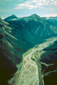
Kicking Horse Pass is a route through the Rocky Mountains. At an elevation of 1,627 m, Kicking Horse Pass straddles the Continental Divide on the border between Alberta and British Columbia in Yoho National Park. In 1971, Kicking Horse Pass was designated a National Historic Site for its importance as a transportation corridor in Western Canada, first for Indigenous peoples, then the Canadian Pacific Railway, and finally the Trans-Canada Highway.
"https://d3d0lqu00lnqvz.cloudfront.net/media/media/c2e8193c-32fb-430e-b2c8-7399eee67818.jpg" // resources/views/front/categories/view.blade.phphttps://d3d0lqu00lnqvz.cloudfront.net/media/media/c2e8193c-32fb-430e-b2c8-7399eee67818.jpg
Article
The Kicking Horse River begins as glacial meltwater streams flowing down the west slope of the Rocky Mountains.
"https://www.thecanadianencyclopedia.ca/images/tce_placeholder.jpg?v=e9dca980c9bdb3aa11e832e7ea94f5d9" // resources/views/front/categories/view.blade.phphttps://www.thecanadianencyclopedia.ca/images/tce_placeholder.jpg?v=e9dca980c9bdb3aa11e832e7ea94f5d9
Article
Killiniq Island, 269 km2, is located off the northern tip of the Labrador Peninsula on the south side of the entrance to Hudson Strait. The provincial boundary passes across the island, so that its eastern portion belongs to Newfoundland and the rest is part of Nunavut.
"https://www.thecanadianencyclopedia.ca/images/tce_placeholder.jpg?v=e9dca980c9bdb3aa11e832e7ea94f5d9" // resources/views/front/categories/view.blade.phphttps://www.thecanadianencyclopedia.ca/images/tce_placeholder.jpg?v=e9dca980c9bdb3aa11e832e7ea94f5d9
"https://d3d0lqu00lnqvz.cloudfront.net/media/media/53c26b08-3e98-4cb1-b146-fc3654a0854a.jpg" // resources/views/front/categories/view.blade.phphttps://d3d0lqu00lnqvz.cloudfront.net/media/media/53c26b08-3e98-4cb1-b146-fc3654a0854a.jpg

Article
Spruce forest is common below about 1200 m elevation, but the upper slopes of the ranges are treeless. The area supports an abundance of wildlife, including grizzly and BLACK BEAR, timber wolf, Dall sheep, mountain goat, caribou and moose.
"https://www.thecanadianencyclopedia.ca/images/tce_placeholder.jpg?v=e9dca980c9bdb3aa11e832e7ea94f5d9" // resources/views/front/categories/view.blade.phphttps://www.thecanadianencyclopedia.ca/images/tce_placeholder.jpg?v=e9dca980c9bdb3aa11e832e7ea94f5d9
Article
Kootenay Lake, 407 km2, elev 532 m, is situated in the mountainous southeastern interior of BC.
"https://d3d0lqu00lnqvz.cloudfront.net/media/media/889433fb-787d-4d50-9c0d-a3cfcfcff6a5.jpg" // resources/views/front/categories/view.blade.phphttps://d3d0lqu00lnqvz.cloudfront.net/media/media/889433fb-787d-4d50-9c0d-a3cfcfcff6a5.jpg

Article
La Grande Rivière, 893 km long, rises in the rugged forest highlands of central Québec and drains west into James Bay.
"https://d3d0lqu00lnqvz.cloudfront.net/media/media/33649494-8426-4ec2-8001-9f2613ea3d08.jpg" // resources/views/front/categories/view.blade.phphttps://d3d0lqu00lnqvz.cloudfront.net/media/media/33649494-8426-4ec2-8001-9f2613ea3d08.jpg
