Article
Prince of Wales Fort
Prince of Wales Fort is an 18th-century fortification built by the Hudson’s Bay Company at the mouth of the Churchill River, in what is now Manitoba. Today, it is a national historic site managed by Parks Canada.
Signing up enhances your TCE experience with the ability to save items to your personal reading list, and access the interactive map.
Create AccountArticle
Prince of Wales Fort is an 18th-century fortification built by the Hudson’s Bay Company at the mouth of the Churchill River, in what is now Manitoba. Today, it is a national historic site managed by Parks Canada.
"https://d3d0lqu00lnqvz.cloudfront.net/media/media/8c5faba2-5909-4aa1-ba38-6e503757042e.jpg" // resources/views/front/categories/view.blade.phphttps://d3d0lqu00lnqvz.cloudfront.net/media/media/8c5faba2-5909-4aa1-ba38-6e503757042e.jpg

Article
Prince of Wales Island, Nunavut, 33 339 km2, is the eighth-largest island in the Arctic Archipelago.
"https://d3d0lqu00lnqvz.cloudfront.net/media/media/79d1e122-c898-4f67-8500-8c2d799e7700.jpg" // resources/views/front/categories/view.blade.phphttps://d3d0lqu00lnqvz.cloudfront.net/media/media/79d1e122-c898-4f67-8500-8c2d799e7700.jpg

Article
Prince of Wales Strait is situated in the Arctic Archipelago between the uplands of western Victoria Island and the east coast of Banks Island.
"https://d3d0lqu00lnqvz.cloudfront.net/media/media/6fcc972b-865e-4086-b585-c230cb7d350b.jpg" // resources/views/front/categories/view.blade.phphttps://d3d0lqu00lnqvz.cloudfront.net/media/media/6fcc972b-865e-4086-b585-c230cb7d350b.jpg

Article
Prince Patrick Island, 15 848 km2, is the farthest west of Canada's Arctic Queen Elizabeth Islands.
"https://www.thecanadianencyclopedia.ca/images/tce_placeholder.jpg?v=e9dca980c9bdb3aa11e832e7ea94f5d9" // resources/views/front/categories/view.blade.phphttps://www.thecanadianencyclopedia.ca/images/tce_placeholder.jpg?v=e9dca980c9bdb3aa11e832e7ea94f5d9

Article
Prince Rupert, BC, incorporated as a city in 1910, population 12,300 (2021 census), 12,220 (2016 census). The City of Prince Rupert is located on Kaien Island, at the mouth of the Skeena River in the Coast Mountains of British Columbia. It is Canada's wettest city, with an average of 2,619 mm of precipitation falling each year. Prince Rupert marks western end of the Yellowhead Trans-Canada Highway and, as Canada's deepest ice-free seaport, a link between the lower United States, Vancouver and Alaska (see also Iconic Highways in Canada). For these reasons it is the industrial, commercial and institutional centre for BC's Northwest Coast.
"https://d3d0lqu00lnqvz.cloudfront.net/media/media/adb7f8d5-a8d7-465c-8567-2d8d0de2e468.jpg" // resources/views/front/categories/view.blade.phphttps://d3d0lqu00lnqvz.cloudfront.net/media/media/adb7f8d5-a8d7-465c-8567-2d8d0de2e468.jpg

Article
Considered a Toronto landmark, the Princess of Wales Theatre is located at 300 King Street West in Toronto's entertainment district.
"https://d3d0lqu00lnqvz.cloudfront.net/media/media/2377ba89-8cef-4261-8bc5-9705d3ff2c4d.jpg" // resources/views/front/categories/view.blade.phphttps://d3d0lqu00lnqvz.cloudfront.net/media/media/2377ba89-8cef-4261-8bc5-9705d3ff2c4d.jpg

Article
Princeton, BC, incorporated as a town in 1978, population 2724 (2011c), 2780 (2006c). The Town of Princeton is located at the junction of the Tulameen and Similkameen rivers, 114 km west of PENTICTON.
"https://www.thecanadianencyclopedia.ca/images/tce_placeholder.jpg?v=e9dca980c9bdb3aa11e832e7ea94f5d9" // resources/views/front/categories/view.blade.phphttps://www.thecanadianencyclopedia.ca/images/tce_placeholder.jpg?v=e9dca980c9bdb3aa11e832e7ea94f5d9
Article
Principal Reservoirs in Canada Principal Reservoirs in Canada Reservoir River Province Storage Capacity* Year Operational Lake St Lawrence St Lawrence Ontario 808 1958 Cross-Cedar Lake Saskatchewan Manitoba 9643 1965 Williston Lake Peace BC 70 309 1968 Manicouagan Manicouagan Québec 141 851 1968 Lake Diefenbaker South Saskatchewan Saskatchewan 9868 1972 Kinbasket Lake Columbia BC 24 670 1972 Wreck Cove Wreck Cove Nova Scotia 126 1978 Hinds Lake Humber Newfoundland 305 1980 SmallwoodChurchillLabrador28 0001971 *millions of cubic...
"https://www.thecanadianencyclopedia.ca/images/tce_placeholder.jpg?v=e9dca980c9bdb3aa11e832e7ea94f5d9" // resources/views/front/categories/view.blade.phphttps://www.thecanadianencyclopedia.ca/images/tce_placeholder.jpg?v=e9dca980c9bdb3aa11e832e7ea94f5d9
Article
Province House, Halifax, built between 1811 and 1818 to house Parliament, the courts and the public service of Nova Scotia.
"https://www.thecanadianencyclopedia.ca/images/tce_placeholder.jpg?v=e9dca980c9bdb3aa11e832e7ea94f5d9" // resources/views/front/categories/view.blade.phphttps://www.thecanadianencyclopedia.ca/images/tce_placeholder.jpg?v=e9dca980c9bdb3aa11e832e7ea94f5d9
Article
Province House in Charlottetown is the home of Prince Edward Island's Legislative Assembly.
"https://www.thecanadianencyclopedia.ca/images/tce_placeholder.jpg?v=e9dca980c9bdb3aa11e832e7ea94f5d9" // resources/views/front/categories/view.blade.phphttps://www.thecanadianencyclopedia.ca/images/tce_placeholder.jpg?v=e9dca980c9bdb3aa11e832e7ea94f5d9
Article
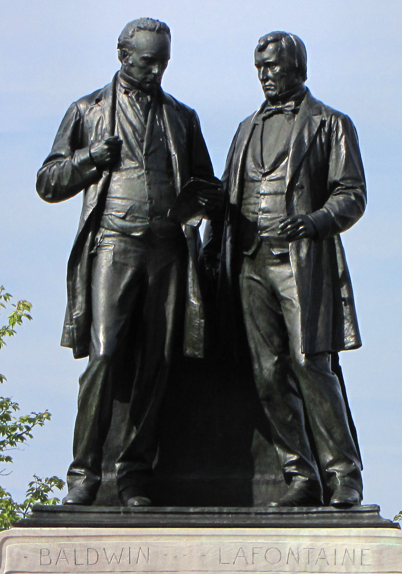
In 1841, Britain united the colonies of Upper and Lower Canada into the Province of Canada. This was in response to the violent rebellions of 1837–38. The Durham Report (1839) recommended the guidelines to create the new colony with the Act of Union. The Province of Canada was made up of Canada West (formerly Upper Canada) and Canada East (formerly Lower Canada). The two regions were governed jointly until the Province was dissolved to make way for Confederation in 1867. Canada West then became Ontario and Canada East became Quebec. The Province of Canada was a 26-year experiment in anglophone-francophone political cooperation. During this time, responsible government came to British North America and expanded trade and commerce brought wealth to the region. Leaders such as Sir John A. Macdonald, Sir George-Étienne Cartier and George Brown emerged and Confederation was born. (This is the full-length entry about the Province of Canada. For a plain language summary, please see Province of Canada (Plain Language Summary).)
"https://d3d0lqu00lnqvz.cloudfront.net/media/media/dcae055f-192e-4de7-b004-4a70146eca56.jpg" // resources/views/front/categories/view.blade.phphttps://d3d0lqu00lnqvz.cloudfront.net/media/media/dcae055f-192e-4de7-b004-4a70146eca56.jpg
Article
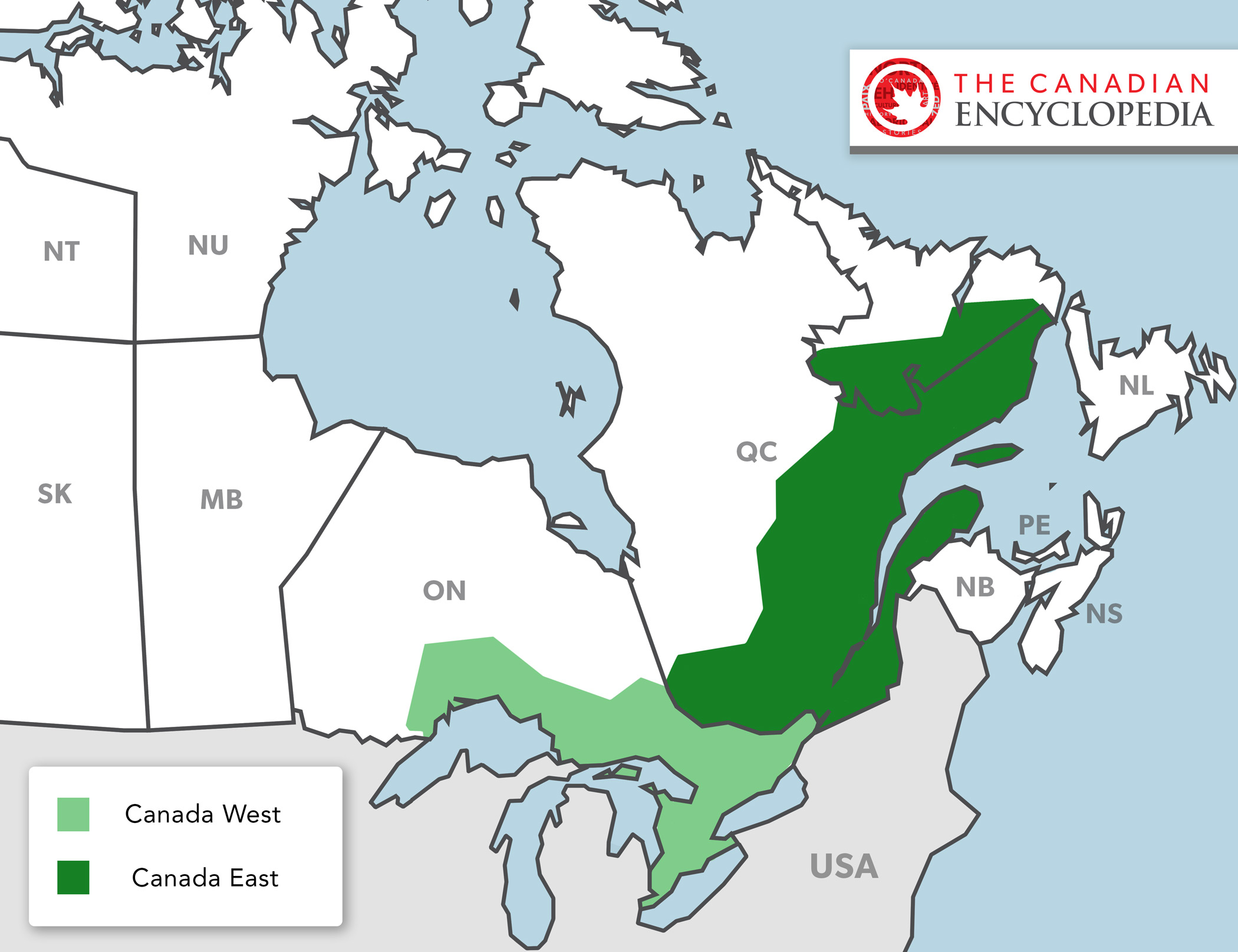
The Province of Canada existed between 1841 and 1867. The legislation that created the Province of Canada was called the Act of Union. The Province of Canada included parts of what are now Ontario, Quebec and Labrador. Before 1841, the region was made up of two British colonies. They were called Upper Canada and Lower Canada. When Britain created the Province of Canada, it combined these two colonies into one. In the new colony, Upper Canada became known as Canada West. Lower Canada was known as Canada East. The people in Canada West were mostly English. The people in Canada East were mostly French. (This article is a plain-language summary about the Province of Canada. If you are interested in reading about this topic in more depth, please see our full-length entry Province of Canada.)
"https://d3d0lqu00lnqvz.cloudfront.net/media/new_article_images/PoliticsInOntario/Map_Canada_West_East.jpg" // resources/views/front/categories/view.blade.phphttps://d3d0lqu00lnqvz.cloudfront.net/media/new_article_images/PoliticsInOntario/Map_Canada_West_East.jpg
Article
The Rooms is a cultural centre located in St. John’s, Newfoundland, that showcases the history, heritage and art of Newfoundland and Labrador.
"https://d3d0lqu00lnqvz.cloudfront.net/media/media/aa2ca852-f096-4ffa-9886-12f3dd59bb1f.jpg" // resources/views/front/categories/view.blade.phphttps://d3d0lqu00lnqvz.cloudfront.net/media/media/aa2ca852-f096-4ffa-9886-12f3dd59bb1f.jpg

Article
This image of Reesor Lake in Cypress Hills Interprovincial Park depicts mixed spruce, aspen woodland and fescue grassland (photo by Cliff Wallis, courtesy Cottonwood Consultants Ltd.).Typical boreal shield country in northern Ontario (photo by Brian Milne/First Light).PreviousNext Parks, Provincial Provincial parks are areas of land and water, large or small, natural or man-modified, designated by any of the provincial governments for the purposes of nature protection, recreation, TOURISM, historic preservation and education. They range in...
"https://d3d0lqu00lnqvz.cloudfront.net/media/media/ca373d61-2489-44ec-a604-201d64f5116e.jpg" // resources/views/front/categories/view.blade.phphttps://d3d0lqu00lnqvz.cloudfront.net/media/media/ca373d61-2489-44ec-a604-201d64f5116e.jpg

Article
Prud'homme, Saskatchewan, incorporated as a village in 1922, population 167 (2016 census), 172 (2011 census). The village of Prud'homme is located about 45 km northeast of Saskatoon. Prud'homme is the hometown of Jeanne Sauvé, a former cabinet minister in the Pierre Trudeau government, the first woman to hold the position of Speaker of the House of Commons and the first woman to act as Governor General of Canada.
"https://www.thecanadianencyclopedia.ca/images/tce_placeholder.jpg?v=e9dca980c9bdb3aa11e832e7ea94f5d9" // resources/views/front/categories/view.blade.phphttps://www.thecanadianencyclopedia.ca/images/tce_placeholder.jpg?v=e9dca980c9bdb3aa11e832e7ea94f5d9