Share on Facebook
 Share on X
 Share by Email
 Share on Google Classroom
Lake Superior National Marine Conservation Area
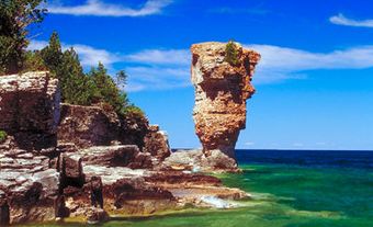
Located in the westernmost part of the GREAT LAKES, the Lake Superior National Marine Conservation Area, created in 2007, is the world's largest freshwater protected area at 10 850 km2. The Lake Superior National Marine Conservation Area protects one-eighth of LAKE SUPERIOR, including 60 km2 of shoals and small islands.Natural History
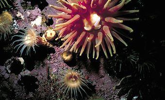
Lake Superior is an ultra-oligotrophic lake - deep, cold and nutrient-poor. These conditions result in little plant growth, rendering the lake relatively unproductive in comparison to the lower Great Lakes. Subarctic and alpine vegetation, which took hold after the last glaciations 10 000 years ago, persist on the smaller islands today. These islands have proven ideal for colonial breeding birds including herring and ring-billed gulls, great blue heron and double-crested cormorant. Bald eagle, osprey and PEREGRINE FALCON also summer in the area, as does the American white pelican.The larger islands in the archipelago support a range of fauna - among the largest of them, woodland caribou, moose, deer, bear, wolves and beaver. The waters themselves are home to over 70 species of fish, and support both a commercial and sport fishery. Recreational fishermen troll for salmon and lake trout in the open water, while whitefish and perch can be caught in the shallower, protected bays. Lake whitefish and lake herring are important commercially.
Human History
PALAEOINDIANS were first to come to the Great Lakes around 7000 to 8000 BC. Successors are not well documented, but include the Laurel peoples (culture known for its pottery, 500 BC to 800 AD). The area is now the territorial lands of the OJIBWA peoples.
Europeans arrived on the "upper lake" around 1622 in search of new trade routes to the Far East. Étienne BRÛLÉ, one of Samuel de CHAMPLAIN's interpreters, reported a rich bounty of furs, timbers and minerals on these lands, and the development of Superior's north shore began.
Shipping remained the main mode of travel until 3 Nov 1885, when the last spike of the Canadian Pacific Railway, connecting Montréal to Winnipeg, was driven in at the eastern end of the NATIONAL MARINE CONSERVATION AREA.
Today, THUNDER BAY is the largest city on Canada's north shore of Superior. Several coastal communities maintain a tenuous foothold in the shadow of a downturned economy, dependent on the forest and mining industries.