Share on Facebook
 Share on X
 Share by Email
 Share on Google Classroom
Early History
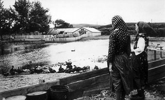
Lethbridge is located on the traditional territory of the Blackfoot Confederacy. The area was part of their summer hunting grounds. Europeans did not have a significant presence in the area until 1869, when Montana traders built Fort Whoop-Up. Fort Whoop-Up one of the most notorious whisky-trading posts in the Prairie West.
Settlement and Development

In 1882, the North Western Coal and Navigation Company, directed by Sir Alexander Galt and his son Elliott, opened their first coal mine in Lethbridge. In 1885, large-scale coal mining became feasible when the Canadian Pacific Railway was extended its line from Dunmore, near Medicine Hat, to the mining camp. Named Lethbridge in 1884 after North Western Coal's first president, William Lethbridge, the community was incorporated as a town in 1890.
A second rail link leading to the Montana border was completed in 1890. The CPR began to operate the Lethbridge-Dunmore line in 1897 and extended it west to serve the coal mines in the Crowsnest Pass. Lethbridge was incorporated as a city in 1906. In 1909, the CPR completed an impressive single-track viaduct across the Oldman River Valley. Just over 1.6 km long and 96 m above the valley floor, it is Lethbridge's most dramatic landmark. Railway improvements made Lethbridge the principal transportation junction and largest marketing and distribution centre between Calgary and the US border.
Irrigation played an important role in the evolution of Lethbridge when agriculture displaced coal as the key local resource and the main source of jobs. Between 1898 and 1900, Mormon migrants from Utah built a 185-kilometre long system of canals to divert the St. Mary River, the first large-scale irrigation system in Western Canada. The land area supplied with irrigation water expanded between the World Wars and doubled between 1965 and 1985.
Economy
The majority of the land under irrigation in the Lethbridge area is devoted to forage and grain crops grown principally as livestock feed. However, irrigation also supports the production of canola, sugar beets, pulses and vegetables, and these are processed in the Lethbridge area. The manufacturing sector features several food-processing industries as well as some heavy manufacturing.
Irrigation water is also a vital ingredient for the many large-scale livestock operations found less than 20 km from the city's northern boundary. These livestock farms have a significant local economic impact, creating employment in livestock trade and transportation, as well as in companies supplying the agricultural sector (see also Animal Agriculture).
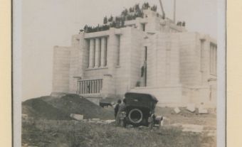
The city functions as the service centre for surrounding agricultural communities; however, the information economy is also important. This is evident in the growth of Lethbridge College (1957), the Lethbridge Research Centre and Development Centre (1906, which houses both federal and provincial agricultural research facilities) and the University of Lethbridge (1967). Both the university and the college are significant employers.
Lethbridge has become a retirement destination with adult condominiums and residences offering various levels of care for the elderly. These have become a noticeable feature of the cityscape and its economic structure.
Cityscape
Until 1968 the city was located entirely on the east side of the Oldman River. The street grid was traditionally divided by the Canadian Pacific Railway into a north side (working-class district located close to the coal mines) and a south side (middle-class merchants and professionals). As a mining town, Lethbridge was never wealthy. Tree-shaded streets in residential neighbourhoods dating back to the turn of the 20th century are lined with modest wood-frame houses; brick and stone were rarities as residential construction materials. The city's last coal mine was shut down in 1957; however, its tipple, water tower and machinery buildings still exist and are a reminder of the city's mining heritage.
In 1971, the university moved to a new campus on the west side of the river. Up until this point the west side of the river had been a sparsely populated rural area. This major new investment prompted a westward shift in the orientation of the city. With the construction of the university came a new road bridge and many new residential neighbourhoods in West Lethbridge.
In 1985, the CPR marshalling yards were relocated outside the city, making a large land parcel in the core of the city available for redevelopment. Because of this, the downtown saw substantial investment in the 1980s and 1990s, including a diverse mix of commercial, housing and public-sector redevelopment.
The Oldman River Valley bisects the city, and a chain of parks runs from south to north through the valley bottom. Indian Battle Park commemorates the defeat of a Cree war party by Kainai (Blood) and Piikani (Peigan) warriors in 1870. Galt Gardens, an inner-city park covering four blocks, forms the core of the downtown, while Henderson Lake and Nicholas Sheran parks provide artificial water bodies in suburban areas. The Nikka Yuko Japanese Garden is a striking feature on the shores of Henderson Lake, drawing attention to the city's Japanese community.
Cultural Life
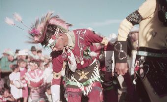
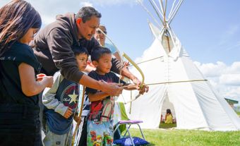
Lethbridge has an unusual mix of cultural and ethnic groups. Mormons occupy a prominent place in the economic and social life of the city. Though they live in colonies outside the city, Hutterites are a distinctive part of the downtown scene, especially on Thursdays when they appear in the core area to shop and socialize. Blood 148, Canada's largest reserve in terms of land area, lies just west of the city, and a growing number of First Nations people have been attracted to Lethbridge's urban lifestyle and its employment opportunities. A number of Mennonite churches and Buddhist temples, as well as a Muslim centre add further variety to Lethbridge's cultural life.
Recreational sports are accommodated in ice arenas, indoor pools, baseball and softball diamonds, and an indoor soccer complex. Spitz Stadium is home to the Lethbridge Bulls of the Western Major Baseball League; the University of Lethbridge Community Stadium supports football, rugby and soccer; and ENMAX Centre houses the Lethbridge Hurricanes of the Western Hockey League.
The Yates Memorial Centre is home to the Lethbridge Symphony Orchestra and several theatre companies. The award-winning Southern Alberta Art Gallery hosts a variety of travelling exhibitions in the downtown area while the University of Lethbridge has one of the largest art collections of any university in Canada. Casa, an interdisciplinary arts centre, accommodates an exhibition gallery, classrooms and studios for visual and performing arts.
In the river valley’s bottom, a replica of Fort Whoop-Up provides visitors with a vivid portrayal of 19th-century commerce in the North-West Territories. Overlooking the river valley, the Sir Alexander Galt Museum and Archives houses permanent and travelling exhibitions depicting the history of the region. Located in a nature reserve, the Helen Schuler Coulee Centre offers opportunities to explore the natural history and ecosystem of the Oldman River Valley.