Share on Facebook
 Share on X
 Share by Email
 Share on Google Classroom
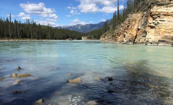
Peace River, 1,923 km long, is one of the principal tributaries of the Mackenzie River system. The name of the river refers to a settlement between Cree and Dane-Zaa (Beaver) warring parties around 1781 at Peace Point at the lower portion of the river. The Dane-Zaa word for the river is unchaga, meaning “big river”; the Cree word for the settlement there is sâkitawâhk.

The Peace River flows through the town of the same name, in Alberta.
The river and its tributaries were formed from 10,000 to 15,000 years ago when Glacial Lake Peace began to melt and drain. Formerly, the Peace was formed by the juncture of the Finlay River from the north and the Parsnip River from the south. In the late 1960s, the forks of the three rivers were dammed, with the water swelling to form Williston Lake. The Peace flows from the east arm of the lake, cuts through the Rocky Mountains and is joined by the Halfway and Beatton rivers from the north and the Pine River from the south. It continues eastward and cuts a deep gash, up to 11 km wide, across the northwestern Alberta prairie. Near the town of Peace River, it is joined by the Smoky River and swings abruptly north, meandering to near Fort Vermilion, where it turns east and, joined by the Wabasca River, flows into Wood Buffalo National Park. It then pours into the Slave River, whence its waters are carried to Great Slave Lake, which is drained by the Mackenzie.
Following Alexander Mackenzie’s famous voyage to the Pacific Ocean, other traders travelled up the river, and, beginning with Boyer’s Post near Fort Vermilion in 1788, more than 20 trading establishments were constructed, including five different posts built at various times around the location of Fort St. John. Simon Fraser built a strategic post, Rocky Mountain Portage House, at the head of navigation in 1805 (now present-day Hudson’s Hope). The river remained a major freighting route well into the 20th century.
The valley of the Peace River is fertile; it is the northernmost commercially important agricultural region of North America (see also Peace River Lowland). The great Gordon M. Shrum hydroelectric power station near Hudson’s Hope began producing electricity in 1968 and at 2,730 megawatts is the third largest in Canada; nearby Peace Canyon station generates additional power. The dams were built amid some controversy, for the levels of the water, especially along the Peace Athabasca Delta, were greatly affected. In 1982, the delta was designated a Ramsar site — a wetland of international importance.