Share on Facebook
 Share on X
 Share by Email
 Share on Google Classroom
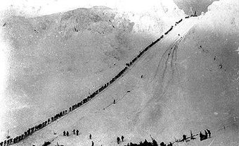
Eagle Pass, elevation about 550 m, provides a corridor through the Gold Range in the Monashee Mountains between Shuswap Lake and the Columbia River, 12 km southwest of Revelstoke, British Columbia. In 1865 Walter Moberly, BC's assistant surveyor general, set out to explore the interior for possible railway passes through the mountain barrier east of Shuswap Lake, and discovered and named the pass after he had shot up a nest of eagles that flew away through it. Eagle Pass was chosen as the Canadian Pacific Railway route through the Monashees; there the western railway portion from Port Moody met the eastern rail crews, and on 7 November 1885 the last spike was driven at Craigellachie, west of the pass. The Trans-Canada Highway also traverses the pass.
-
- MLA 8TH EDITION
- Boles, Glen. "Eagle Pass". The Canadian Encyclopedia, 31 March 2016, Historica Canada. www.thecanadianencyclopedia.ca/en/article/eagle-pass. Accessed 17 April 2024.
- Copy
-
- APA 6TH EDITION
- Boles, G. (2016). Eagle Pass. In The Canadian Encyclopedia. Retrieved from https://www.thecanadianencyclopedia.ca/en/article/eagle-pass
- Copy
-
- CHICAGO 17TH EDITION
- Boles, Glen. "Eagle Pass." The Canadian Encyclopedia. Historica Canada. Article published February 07, 2006; Last Edited March 31, 2016.
- Copy
-
- TURABIAN 8TH EDITION
- The Canadian Encyclopedia, s.v. "Eagle Pass," by Glen Boles, Accessed April 17, 2024, https://www.thecanadianencyclopedia.ca/en/article/eagle-pass
- Copy
Thank you for your submission
Our team will be reviewing your submission
and get back to you with any further questions.
Thanks for contributing to The Canadian Encyclopedia.
CloseArticle
Eagle Pass
Article by Glen Boles
Published Online February 7, 2006
Last Edited March 31, 2016
Eagle Pass, elevation about 550 m, provides a corridor through the Gold Range in the Monashee Mountains between Shuswap Lake and the Columbia River, 12 km southwest of Revelstoke, British Columbia.