Share on Facebook
 Share on X
 Share by Email
 Share on Google Classroom


Meteorology
Meteorology is the science that studies the atmosphere and atmospheric phenomena, using data about temperature, HUMIDITY, CLOUD, WIND, etc. Its ultimate aim is to explain the structure and functioning of the atmosphere using the basic laws of PHYSICS. The major theoretical divisions are physical and dynamic meteorology (very closely related and often coupled under the title atmospheric physics) and synoptic meteorology. CLIMATOLOGY is the branch of meteorology most concerned with WEATHER, CLIMATE and CLIMATE CHANGE.
Physical Meteorology
Physical meteorology links meteorology and physics in studies of 3 core topics: electromagnetic radiation, meteorological thermodynamics and cloud physics. Related topics include stratospheric physics, atmospheric electricity, optics and ACOUSTICS.
Radiation
Solar radiation is received by Earth mostly as visible and near-infrared light. About 30-35% is lost to space by reflection from clouds and the Earth's surface. Most, however, is absorbed by the Earth's surface and re-emitted as infrared radiation, which is absorbed by water, carbon dioxide (CO2) and pollutants in the air. In the long term, the solar radiation received by Earth and its atmosphere at any point is balanced by infrared radiation emitted to space. Temporary imbalances (eg, the summer surplus and winter deficit in incoming solar radiation in Canada) result in large seasonal temperature changes, except where moderated by oceans. Radiative exchange processes are of central importance in computer models for long-range WEATHER FORECASTS and climate change. Radiation is used extensively in REMOTE SENSING of weather elements from satellites, aircraft and surface instruments.
Meteorological Thermodynamics
Meteorological thermodynamics assumes that air is a mixture of dry air and water vapour, each characterized by temperature, pressure and density, interrelated in an equation of state. Temperature variations cause pressure changes that drive the winds. Local cooling causes condensation and the release of latent heat. Complex interactions among the state variables, clouds, winds and radiation are studied using the laws of thermodynamics and computer simulation.
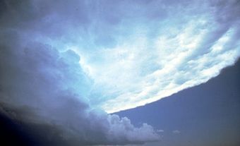
Cloud Physics
Cloud physics is the study of cloud and precipitation particles and the physical processes that take place in natural and artificial clouds. Water vapour condenses on tiny hygroscopic particles called condensation nuclei to form cloud and FOG droplets. At temperatures far below freezing, water vapour condenses on soil particles and other freezing nuclei to form ice crystal clouds. In favourable circumstances, droplets and crystals grow into raindrops and snowflakes, or even hailstones, by collision and coalescence and by transfer of water vapour from droplets to crystals in a mixed cloud (see ICE). Scientific experiments on modification of clouds, fog and precipitation for purposes of rainfall enhancement, HAIL suppression, visibility improvement and forest-fire suppression have been conducted in Canada with mixed results since about 1950 (seeRAINMAKING).
The stratosphere (upper atmosphere) imposes thermodynamic constraints on air motions in the weather layer (troposphere) below, and acts as a reservoir for gases and fine particles that influence radiation streams. LIGHTNING, ionization and the air-earth current are elements of atmospheric electricity. Electrical processes are thought to be important in the physics of clouds and precipitation. Atmospheric optics and acoustics embrace studies of transmission, reflection, refraction and diffraction of light or sound. The results are applied to such phenomena as RAINBOWS, mirages, scintillation, wind sounds and echoes, and to the use of light and sound in remote sensing, as in laser or acoustic RADAR, cloud photography and the sonic anemometer-thermometer.
K.D. HAGE
Dynamic Meteorology
Dynamic meteorology is the science of atmospheric motions. Because the Earth's atmosphere is a complex physical system subjected to a number of external influences, such as heating and cooling by the land and ocean masses, a wealth of phenomena involving air motion are observed. The largest is the belt of westerlies; ie, winds blowing from west to east, circling the Earth in the middle latitudes. These westerlies are normally disturbed and forced to wander northward and southward in a snakelike fashion. The core of this meandering current, the JET STREAM, normally located 10-12 km above sea level, can have winds of over 300 km/h. The wavy structure of the jet stream is caused by the deflecting effect of large mountains such as the Rockies, by heating or cooling of the underlying surface and by travelling vortices measuring as much as a few thousand kilometres in diameter. These vortices can be viewed as clockwise or counterclockwise circulations superimposed on the main westerlies and causing the latter to be deflected around them. Some of the larger vortices can remain nearly stationary for periods of several days; smaller, weaker vortices are swept downstream by the jet current. There is an intricate interplay between the jet stream and the vortices, each affecting the other in ways that depend on their relative strengths and configurations.
Near the Earth's surface the circulation is dominated by the vortices because the jet stream becomes feeble at low altitudes. These are the systems seen on sea-level weather maps on which are drawn isobars - lines connecting points of identical pressure. In the Northern Hemisphere, clockwise vortices have a high central pressure (anticyclones), while counterclockwise vortices have a low central pressure (cyclones); in the Southern Hemisphere the opposite circulations around "highs" and "lows" are observed. Lows are normally associated with areas of cloud and, often, precipitation; highs are usually accompanied by clear skies. Far less frequent but much more violent is the HURRICANE, or typhoon, one of the most intense and feared storms. Ranging in size about 100-1000 km, they are normally found only in the tropics and subtropics. On a still smaller scale is the THUNDERSTORM, with a typical dimension of 5-10 km, and the destructive TORNADO, typically having a diameter of a few hundred metres and winds estimated at up to 450 km/h.
Dynamic meteorology uses the laws of hydrodynamics and thermodynamics to investigate various types of atmospheric circulations. The former describe how different forces (eg, gravity acting on a parcel of air) will affect its velocity; the latter provide information on the temperature change that results when a certain amount of heat is added or extracted from the air. The procedure may be most easily visualized if the atmosphere is subdivided into a large number of imaginary volumes (cubes or similar shapes). If all forces acting on the volume and the velocity of the air are known, it is possible to compute the displacement of the air over a period of time. Similarly, if at a given instant the temperature inside a given volume is known and the amount of heat entering or leaving it can be determined, it is possible to compute what the temperature inside the volume will be a short time later. This is fundamentally the method used to produce weather forecasts by electronic computers. Calculations are most accurate when volumes are small; hence, forecasts for large regions, such as a continent or hemisphere, are feasible only on powerful computers.
JACQUES DEROME
Synoptic Meteorology
Synoptic meteorology is the analysis of meteorological data, obtained more or less simultaneously from a large geographical area, in order to present a comprehensive and nearly instantaneous picture of the state of the atmosphere. Frequently, data will be obtained over an extended period so that the development of meteorological systems may also be studied. Synoptic meteorology is very closely related to physical and dynamic meteorology and to general climatology, and may be considered a synthesis of these disciplines. Phenomena of interest to the synoptic meteorologist occur on many spatial and temporal scales. Major hemispheric circulation patterns (including jet streams) in the middle and upper troposphere (lower atmosphere) typically span 10 000 km or more and may persist for weeks or months. These major circulation patterns tend to control and interact with smaller-scale phenomena, eg, cyclones and anticyclones.
Cyclones are vortices having a relatively low central pressure. At the Earth's surface, the air tends to spiral inward toward the centre of the cyclone, where it is forced to rise. Since the rising air will be cooled by adiabatic expansion (ie, expansion that occurs without the addition of heat) at a rate of about 1° C per 100 m, some of the water vapour will condense to form cloud droplets. If there is sufficient moisture and if the air ascends high enough, precipitation will occur. Anticyclones have a relatively high central pressure. Near the Earth's surface, the air generally spirals outward from the centre. Near the centre of an anticyclone, the air is generally subsiding; consequently, clouds tend to dissipate and fair weather is frequently observed.
Cyclones and anticyclones occur in middle latitudes and are one of the principal means by which heat and moisture are redistributed throughout the atmosphere. Solar heating in equatorial regions and cooling in polar regions will create strong horizontal thermal gradients. These gradients represent sources of potential energy which, under suitable conditions, may become available for conversion into kinetic energy. It is now generally accepted that cyclones form in order to accomplish this energy conversion.
During the period of development (cyclogenesis), a cyclonic wind field will be initiated (increase in cyclonic kinetic energy). This will occur at the expense of the thermal gradient (decrease in potential energy). At the same time, the kinetic energy is also being destroyed by friction and other dissipative processes in the atmosphere.
Synoptic meteorology is used in weather forecasting to follow the development and evolution of cyclones and anticyclones, as well as a myriad of associated structures such as air masses and fronts (boundaries between dissimilar air masses). In this task the meteorologist is assisted by mathematical models of the atmosphere which are run on digital computers. This interaction between the synoptic meteorologist and computers is the essence of modern weather prediction.
M.E. TRUEMAN
Meteorology in Canada
In Canada, the federal Department of the Environment is responsible for the country's national weather service. The department collects data from all over the world, analyses the information, produces forecasts and weather warnings and distributes them to the general public as well as to industries that are affected by the weather. Environment Canada is also involved in research into the atmosphere. Its scientists are studying smog, CLIMATE CHANGE, GLOBAL WARMING, ACID RAIN, air toxins, the OZONE LAYER and long-range weather forecasts.
History
All this is a far cry from the 4 weather observatories that existed at the time of Confederation in 1867. The man credited with founding Canada's national weather service, George Kingston, was then the director of the Toronto Observatory at the University of Toronto. As director, Kingston had promoted the need for a national weather service to co-ordinate and set standards for collecting data as well as to issue severe weather warnings. Finally in 1871, the Dominion government's Department of Fisheries and Marine gave him $5000 to set up a national meteorological service in Canada, which by then included BC, Manitoba, Ontario, Québec, New Brunswick and Nova Scotia.
It was, however, the Great Nova Scotian Cyclone of 1873 that confirmed the need for a national weather warning system. The meteorologists in Toronto knew the day before about the hurricane that slammed into Cape Breton, killing nearly 1000 people and leaving many more homeless. But they could not send a warning because the telegraph lines between Toronto and Halifax were down. Public outrage over the disaster prompted Ottawa to finance a weather warning service.
By 1876, telegraph lines linked every major city in Eastern Canada. At the beginning of that year the first storm warning was issued. Later in the year, the weather service began sending out the first forecasts prepared in Canada. They were called "probs," for probabilities, and were posted on public buildings. Today, the service distributes its weather forecasts and warnings using every possible medium - NEWSPAPERS, TELEPHONE, RADIO, Weatheradio, TELEVISION and the INTERNET.
Information Gathering
Interestingly, Kingston would probably recognize some of the instruments that are used today to gather information about the temperature, wind, air pressure and relative humidity. In some places, meteorologists still use a mercury barometer to measure the air pressure, and parts of the anemometer, which measures the speed and direction of the wind, bear a strong resemblance to a weather vane. But there have been big changes. Today, measurements are taken not only at the Earth's surface, where people live, but also in the upper atmosphere. This information provides a 3-dimensional picture and gives meteorologists the data needed to prepare forecasts.
For example, weather BALLOONS carry instruments aloft to measure temperature and the winds in the upper parts of the atmosphere. This information is supplemented by automatic sensors on some commercial aircraft. SATELLITES looking down through the atmosphere record the temperature and winds as well as other phenomena such as snow cover and the type and extent of clouds. These snapshots give meteorologists a clear picture of the current situation as well as the information needed to follow the development and motion of weather systems. Radar provides a detailed picture of precipitation systems as they approach. Doppler radar, for instance, can add important information on the wind flow patterns within thunderstorms.
The Canadian weather service's observation network extends from the Atlantic to the Pacific to the Arctic oceans and includes satellites, radar, weather balloons and buoys at sea. This system is linked to systems in other countries. Every day, computers in Environment Canada process about 60 000 weather observations from Canada and around the world. These are used as a starting point for atmospheric computer models and to help meteorologists produce weather forecasts and warnings.
In Canada, the supercomputer at the Canadian Meteorological Centre in Montréal generates atmospheric forecasts that are used to develop regional forecasts. The meteorologists at the 14 weather offices across Canada fine-tune these forecasts for the general public and the aviation, agricultural, energy, forestry, fishing, shipping and other commerical industries. Every day, the national weather service issues about 1300 public weather forecasts for more than 200 regions and about 1000 aviation forecasts for 175 airports. Its primary responsibility, however, is to warn Canadians about dangerous weather conditions that could threaten lives and property. The weather warning program in Canada consists of escalating warning messages that forecasters issue as the conditions warrant.
In the private sector, meteorological companies offer a wide variety of services. For example, several companies provide weather observations and forecasts to the offshore petroleum and gas exploration industry. Other companies specialize in satellites, air quality and computer graphic display systems for weather charts and maps. Still others, such as the Weather Network and its French-language counterpart MétéoMédia, are involved in broadcasting news about the weather.
Research into the atmosphere is an important part of meteorology in Canada. The atmosphere shields us from the sun's harmful ultraviolet rays and creates the natural greenhouse effect that keeps the Earth warm and makes it livable. Research groups in universities and in the federal and provincial governments are investigating how the climate may change as a result of the increasing concentration of greenhouse gases. These gases include carbon dioxide, methane, nitrous oxide and ground-level ozone. They are partly the result of exhaust from cars, trucks, trains and aircraft and of industrial emissions such as those given off when oil, gas and coal are burned for energy. Changes in temperature may alter cloud conditions, snow and ice cover and intensity and distribution of rainfall as well as the frequency of severe weather such as hurricanes, tornadoes, floods and droughts (seeCLIMATE SEVERITY).
The atmosphere also plays a role in the movement of AIR POLLUTANTS, carrying them thousands of kilometres from their original source. For instance, the Arctic was once a pristine wilderness. It is now as polluted as Europe was 100 years ago because of airborne toxics such as PESTICIDES, mercury and polychlorinated biphenyls (PCBs) from northern Russia and Europe. Similarly, sulphur dioxide and nitrogen oxide emissions from industries in one part of North America may be washed back down to earth in snow or rain - sometimes called acid rain - in other parts of the continent. And ground-level ozone, a major component in smog, may be created in one part of the continent but affect the air quality in another, more populated area.
Scientists are also investigating the effect that ozone-depleting substances such as chlorofluorocarbons - sometimes used as refrigerants in air conditioners or propellants in aerosol sprays - are having in the ozone layer in the stratosphere, some 35 to 50 km above the Earth's surface. One result is the thinning of the ozone layer. This in turn allows more of the sun's ultraviolet rays through to the Earth's surface. Ultraviolet radiation causes skin CANCER and cataracts - a permanent clouding of the eyes that reduces vision. In 1992, Canada's national weather service started issuing daily forecasts of UV radiation, based on the day-to-day-changes in the ozone layer. Canada was the first country in the world to develop a UV index. A year later, in 1993, the weather service in partnership with provincial agencies started publishing air quality advisories to warn people when urban smog levels were high.
The Canadian Meteorological and Oceanographic Society is the organization which has as its aim the advancement of meteorology and OCEANOGRAPHY in Canada. Founded in 1939 as a branch of the Royal Meteorological Society, it evolved into the Canadian Meteorological Society in 1967, and in 1977 the Society broadened its scope to include oceanographers. The Society publishes a refereed journal, The Journal, Atmosphere-Ocean and a bimonthly bulletin, CMOS Bulletin SCMO. Membership is around 1000 in 13 centres and chapters and is open to non-Canadians.
GARY PEARSON
Authors contributing to this article: