Share on Facebook
 Share on X
 Share by Email
 Share on Google Classroom
White Pass, elevation 888 m, sits on the Alaska-BC boundary, approximately 125 km south of Whitehorse, YT. In 1887 the federal government sent William OGILVIE to survey the 141st meridian national boundary where it crosses the Yukon River; members of his party found the pass.
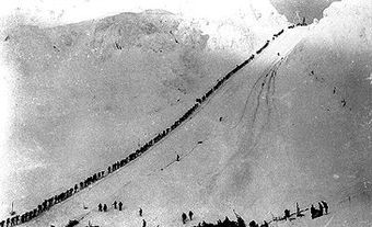
White Pass, elevation 888 m, sits on the Alaska-BC boundary, approximately 125 km south of Whitehorse, YT. In 1887 the federal government sent William OGILVIE to survey the 141st meridian national boundary where it crosses the Yukon River; members of his party found the pass. It was named for Thomas White, then minister of the interior. After the KLONDIKE gold strike (1896), thousands crossed White Pass during 1897 and 1898 to reach the goldfields at DAWSON. The narrow-gauge WHITE PASS AND YUKON RAILWAY from Skagway to Whitehorse was built between 1898 and 1900. It closed in 1982, a year after the highway over the pass was officially opened.