Cities & Populated Places | The Canadian Encyclopedia

Browse "Cities & Populated Places"

Displaying 466-480 of 963 results
  • Article

    London

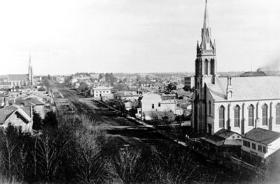
      London, Ont, incorporated as a city in 1855, population 366 151 (2011c), 352 395 (2006c). The City of London, the seat of Middlesex County, is centrally located in the southwest peninsula of the province, on the Québec-Windsor corridor midway between Toronto (185 km) and Windsor (190 km).

    "https://d3d0lqu00lnqvz.cloudfront.net/media/media/05fb552e-40ae-4290-9740-edbcca6e04db.jpg" // resources/views/front/categories/view.blade.php
    
    https://d3d0lqu00lnqvz.cloudfront.net/media/media/05fb552e-40ae-4290-9740-edbcca6e04db.jpg London
  • Article

    Longueuil

    Longueuil, Quebec, population 239,700 (2016 census), 231,409 (2011 census). Longueuil’s history dates to the 17th century with the settling of French colonists. It is today an important suburb of Montreal and is connected to the island of Montreal by the Jacques Cartier bridge and the Louis-Hippolyte-La Fontaine tunnel-bridge. Longueuil is criss-crossed by major expressways linking metropolitan Montreal to Québec city, the Eastern Townships and northern New York State. The municipality of Longueuil is its own entity within the Longueuil agglomeration which includes other nearby cities.Longueuil is situated on the ancestral territory of the Kanyen’kehà:ka. The land remains unceded and is considered Indigenous territory.

    "https://d3d0lqu00lnqvz.cloudfront.net/media/single_use_images/cocathédrale longueuil_cropped.png" // resources/views/front/categories/view.blade.php
    
    https://d3d0lqu00lnqvz.cloudfront.net/media/single_use_images/cocathédrale longueuil_cropped.png Longueuil
  • Article

    Loretteville

    Loretteville, QC, is a neighbourhood in Quebec City. Incorporated as a town in 1947, Loretteville amalgamated with Quebec City in 2002. Loretteville is located about 15 km northwest of downtown Quebec City, on the banks of Rivière Saint-Charles. It is often mistaken for the Huron-Wendat or Wendake reserve, an enclave within Loretteville (see also Reserves in Quebec).

    "https://www.thecanadianencyclopedia.ca/images/tce_placeholder.jpg?v=e9dca980c9bdb3aa11e832e7ea94f5d9" // resources/views/front/categories/view.blade.php
    
    https://www.thecanadianencyclopedia.ca/images/tce_placeholder.jpg?v=e9dca980c9bdb3aa11e832e7ea94f5d9 Loretteville
  • Article

    Lorraine

    Carved out of Bois-des-Filion, SAINTE-THÉRÈSE and ROSEMÈRE, Lorraine was set up as an ecologically sensitive, single-family dwelling, residential community by Anchor Investments Limited.

    "https://d3d0lqu00lnqvz.cloudfront.net/media/media/ec9ac870-e07d-4155-ba11-1b97e5a4ac99.jpg" // resources/views/front/categories/view.blade.php
    
    https://d3d0lqu00lnqvz.cloudfront.net/media/media/ec9ac870-e07d-4155-ba11-1b97e5a4ac99.jpg Lorraine
  • Article

    Lower Canada

    Lower Canada was a British colony from 1791 to 1840. Its geographical boundaries comprised the southern portion of present-day Quebec. In 1791, Britain divided the Province of Quebec into Upper Canada and Lower Canada. (See: Constitutional Act 1791.) Britain had followed a similar policy of territorial division twice before. Prince Edward Island was detached from Nova Scotia in 1769. The provinces of Cape Breton and New Brunswick were created in 1784 in response to the wave of Loyalist immigration (which also occurred in Quebec). In 1841, Upper Canada and Lower Canada were renamed Canada West and Canada East, respectively. They were united as the single colony of the Province of Canada.

    "https://d3d0lqu00lnqvz.cloudfront.net/media/media/0a40188b-4ef4-4e9e-90bb-ec21d39c1c45.jpg" // resources/views/front/categories/view.blade.php
    
    https://d3d0lqu00lnqvz.cloudfront.net/media/media/0a40188b-4ef4-4e9e-90bb-ec21d39c1c45.jpg Lower Canada
  • Article

    Lumsden

    Lumsden, Sask, incorporated as a town in 1905, population 1631 (2011c), 1523 (2006c). The Town of Lumsden is located 26 km northeast of REGINA, nestled in the rolling terrain of the QU'APPELLE RIVER valley. The first settlers arrived in 1881 and named their community Happy Hollow.

    "https://www.thecanadianencyclopedia.ca/images/tce_placeholder.jpg?v=e9dca980c9bdb3aa11e832e7ea94f5d9" // resources/views/front/categories/view.blade.php
    
    https://www.thecanadianencyclopedia.ca/images/tce_placeholder.jpg?v=e9dca980c9bdb3aa11e832e7ea94f5d9 Lumsden
  • Article

    Lunenburg

    Lunenburg, Nova Scotia, incorporated as a town in 1888, population 2,405 (2021 census), 2,262 (2016 census). The town of Lunenburg, the seat of Lunenburg County, is located on Lunenburg Bay, 90 km southwest of Halifax.

    "https://d3d0lqu00lnqvz.cloudfront.net/media/media/814a3eda-73fc-4887-bc3d-07de96548d81.jpg" // resources/views/front/categories/view.blade.php
    
    https://d3d0lqu00lnqvz.cloudfront.net/media/media/814a3eda-73fc-4887-bc3d-07de96548d81.jpg Lunenburg
  • Article

    Lynn Lake

    Lynn Lake, Manitoba, incorporated as a town in 1997, population 482 (2011c), 714 (2006c). The Town of Lynn Lake is a community located 1066 km by road northwest of Winnipeg on the Canadian SHIELD.

    "https://www.thecanadianencyclopedia.ca/images/tce_placeholder.jpg?v=e9dca980c9bdb3aa11e832e7ea94f5d9" // resources/views/front/categories/view.blade.php
    
    https://www.thecanadianencyclopedia.ca/images/tce_placeholder.jpg?v=e9dca980c9bdb3aa11e832e7ea94f5d9 Lynn Lake
  • Article

    Lytton

    Lytton, British Columbia, incorporated as a village in 1945, population 249 (2016 census), 228 (2011 census). The village of Lytton is located on the Trans-Canada Highway, 260 km northeast of Vancouver, at the junction of the Thompson and Fraser rivers. This is one of the driest and warmest spots in Canada.

    "https://d3d0lqu00lnqvz.cloudfront.net/media/media/597fe6e1-a416-4a06-8227-f84345c5562b.jpg" // resources/views/front/categories/view.blade.php
    
    https://d3d0lqu00lnqvz.cloudfront.net/media/media/597fe6e1-a416-4a06-8227-f84345c5562b.jpg Lytton
  • Article

    Mackenzie

    Mackenzie, BC, incorporated as a district municipality in 1966, population 3507 (2011c), 4539 (2006c). The District of Mackenzie is situated in northern British Columbia near the south end of Williston Lake in the Rocky Mountain Trench.

    "https://www.thecanadianencyclopedia.ca/images/tce_placeholder.jpg?v=e9dca980c9bdb3aa11e832e7ea94f5d9" // resources/views/front/categories/view.blade.php
    
    https://www.thecanadianencyclopedia.ca/images/tce_placeholder.jpg?v=e9dca980c9bdb3aa11e832e7ea94f5d9 Mackenzie
  • Article

    Magog

    In 1888 the village of Magog separated from the municipality of Magog Township (established 1855) and soon incorporated as a town.

    "https://www.thecanadianencyclopedia.ca/images/tce_placeholder.jpg?v=e9dca980c9bdb3aa11e832e7ea94f5d9" // resources/views/front/categories/view.blade.php
    
    https://www.thecanadianencyclopedia.ca/images/tce_placeholder.jpg?v=e9dca980c9bdb3aa11e832e7ea94f5d9 Magog
  • Article

    Mahone Bay

    Mahone Bay, NS, incorporated as a town in 1919, population 943 (2011c), 904 (2006c). The Town of Mahone Bay is located on the "Lighthouse Route" of Nova Scotia's southern shore, 10 km northwest of LUNENBURG.

    "https://www.thecanadianencyclopedia.ca/images/tce_placeholder.jpg?v=e9dca980c9bdb3aa11e832e7ea94f5d9" // resources/views/front/categories/view.blade.php
    
    https://www.thecanadianencyclopedia.ca/images/tce_placeholder.jpg?v=e9dca980c9bdb3aa11e832e7ea94f5d9 Mahone Bay
  • Article

    Malartic

    Malartic, Qué, Town, pop 3640 (2006c), 3704 (2001c), inc 1939. Malartic is located 70 km east of ROUYN-NORANDA in northwestern Québec. It was established by Québec's Ministry of Mines, which hoped to end the

    "https://www.thecanadianencyclopedia.ca/images/tce_placeholder.jpg?v=e9dca980c9bdb3aa11e832e7ea94f5d9" // resources/views/front/categories/view.blade.php
    
    https://www.thecanadianencyclopedia.ca/images/tce_placeholder.jpg?v=e9dca980c9bdb3aa11e832e7ea94f5d9 Malartic
  • Article

    Manitouwadge

    Manitouwadge, Ont, incorporated as a township in 1975, population 2105 (2011c), 2300 (2006c). The Township of Manitouwadge is located in northwestern Ontario 397 km northeast of Thunder Bay.

    "https://www.thecanadianencyclopedia.ca/images/tce_placeholder.jpg?v=e9dca980c9bdb3aa11e832e7ea94f5d9" // resources/views/front/categories/view.blade.php
    
    https://www.thecanadianencyclopedia.ca/images/tce_placeholder.jpg?v=e9dca980c9bdb3aa11e832e7ea94f5d9 Manitouwadge
  • Article

    Maniwaki

    The Oblate Fathers founded the mission Notre-Dame du Désert in 1849. Soon after, many settlers moved into the area, drawn by the forest's economic potential. A forest industry was established and provided the livelihood for the residents of the region. In 1851, Maniwaki was declared a parish.

    "https://www.thecanadianencyclopedia.ca/images/tce_placeholder.jpg?v=e9dca980c9bdb3aa11e832e7ea94f5d9" // resources/views/front/categories/view.blade.php
    
    https://www.thecanadianencyclopedia.ca/images/tce_placeholder.jpg?v=e9dca980c9bdb3aa11e832e7ea94f5d9 Maniwaki