Article
Bella Coola (BC)
Bella Coola, BC, Unincorporated Place, population 95 (2011c), 135 (2006c). Bella Coola is a small community situated on the north arm of Burke Channel, where Alexander Mackenzie first sighted the Pacific in 1793.
Signing up enhances your TCE experience with the ability to save items to your personal reading list, and access the interactive map.
Create AccountArticle
Bella Coola, BC, Unincorporated Place, population 95 (2011c), 135 (2006c). Bella Coola is a small community situated on the north arm of Burke Channel, where Alexander Mackenzie first sighted the Pacific in 1793.
"https://www.thecanadianencyclopedia.ca/images/tce_placeholder.jpg?v=e9dca980c9bdb3aa11e832e7ea94f5d9" // resources/views/front/categories/view.blade.phphttps://www.thecanadianencyclopedia.ca/images/tce_placeholder.jpg?v=e9dca980c9bdb3aa11e832e7ea94f5d9

Article
Belledune, NB, incorporated as a village in 1968, population 1548 (2011c), 1711 (2006c). The Village of Belledune was reincorporated in 1994 to include Jacquet River, Armstrong Brook, Archibald Settlement, Sunnyside, Becketville and Mitchell Settlement.
"https://www.thecanadianencyclopedia.ca/images/tce_placeholder.jpg?v=e9dca980c9bdb3aa11e832e7ea94f5d9" // resources/views/front/categories/view.blade.phphttps://www.thecanadianencyclopedia.ca/images/tce_placeholder.jpg?v=e9dca980c9bdb3aa11e832e7ea94f5d9
Article
Belleville, Ontario, incorporated as a city in 1877, population 55,071 (2021 census), 50,716 (2016 census). The city of Belleville, the seat of Hastings County, is located on the Bay of Quinte, an arm of Lake Ontario about 180 km east of Toronto at the mouth of the Moira River.
"https://www.thecanadianencyclopedia.ca/images/tce_placeholder.jpg?v=e9dca980c9bdb3aa11e832e7ea94f5d9" // resources/views/front/categories/view.blade.phphttps://www.thecanadianencyclopedia.ca/images/tce_placeholder.jpg?v=e9dca980c9bdb3aa11e832e7ea94f5d9
Article
In 1848-49 Bellevue was leased to John A. MacDonald, then a member of the Legislative Assembly and receiver general for the Province of Canada. Bellevue was purchased by Parks Canada in 1964 and is now operated as a national historic park. It has been restored to the late 1840s period.
"https://d3d0lqu00lnqvz.cloudfront.net/media/media/d1e095bc-9ecf-4b4d-88e6-2ee41a3c110f.jpg" // resources/views/front/categories/view.blade.phphttps://d3d0lqu00lnqvz.cloudfront.net/media/media/d1e095bc-9ecf-4b4d-88e6-2ee41a3c110f.jpg

Article
Bellot Strait, at 71° 58´ N, separates Somerset Island from the Boothia Peninsula, marking the northernmost point on the mainland of North America.
"https://www.thecanadianencyclopedia.ca/images/tce_placeholder.jpg?v=e9dca980c9bdb3aa11e832e7ea94f5d9" // resources/views/front/categories/view.blade.phphttps://www.thecanadianencyclopedia.ca/images/tce_placeholder.jpg?v=e9dca980c9bdb3aa11e832e7ea94f5d9
Article
Beloeil, Quebec, incorporated as a in city 1914, population 22,458 (2016 census), 20,783 (2011 census). Beloeil is located 32 km east from Montreal on the west bank of the Rivière Richelieu, opposite the city of Mont-Saint-Hilaire. Beloeil, which loosely translated means “beautiful eye,” was probably given to the place by Jean-Baptiste Hertel in 1693. Upon looking out at the panoramic view from atop Mont St-Hilaire, he supposedly cried out, "Qu'elle est belle à oeil!" (What a beautiful eyeful!).
"https://www.thecanadianencyclopedia.ca/images/tce_placeholder.jpg?v=e9dca980c9bdb3aa11e832e7ea94f5d9" // resources/views/front/categories/view.blade.phphttps://www.thecanadianencyclopedia.ca/images/tce_placeholder.jpg?v=e9dca980c9bdb3aa11e832e7ea94f5d9
Article
The Bentley Street Archaeological Site is situated on an extensive flat-topped bedrock knoll overlooking the harbour front of the City of Saint John, New Brunswick.
"https://d3d0lqu00lnqvz.cloudfront.net/media/media/ae1fdfbe-96fc-4754-8a24-c9c1a476dc59.jpg" // resources/views/front/categories/view.blade.phphttps://d3d0lqu00lnqvz.cloudfront.net/media/media/ae1fdfbe-96fc-4754-8a24-c9c1a476dc59.jpg

Article
Beresford, NB, incorporated as a town in 1984, population 4351 (2011c), 4264 (2006c). The Town of Beresford is located 9 km north of BATHURST on CHALEUR BAY and was incorporated as a village in 1967.
"https://www.thecanadianencyclopedia.ca/images/tce_placeholder.jpg?v=e9dca980c9bdb3aa11e832e7ea94f5d9" // resources/views/front/categories/view.blade.phphttps://www.thecanadianencyclopedia.ca/images/tce_placeholder.jpg?v=e9dca980c9bdb3aa11e832e7ea94f5d9
Article
The importance of Beringia is twofold: it provided a pathway for intercontinental exchanges of plants and animals during glacial periods and for interoceanic exchanges during interglacials; it has been a centre of evolution and has supported apparently unique plant and animal communities.
"https://d3d0lqu00lnqvz.cloudfront.net/media/media/b91c5592-6724-4e23-8a45-aa3a4ce223f0.jpg" // resources/views/front/categories/view.blade.phphttps://d3d0lqu00lnqvz.cloudfront.net/media/media/b91c5592-6724-4e23-8a45-aa3a4ce223f0.jpg

Article
Berwick, NS, incorporated as a town in 1923, population 2454 (2011c), 2454 (2006c). The Town of Berwick is located in the Annapolis Valley of Nova Scotia in Kings County, 120 km west of Halifax.
"https://d3d0lqu00lnqvz.cloudfront.net/media/media/f0686d79-7dd7-4948-942f-dc280dc0de97.jpg" // resources/views/front/categories/view.blade.phphttps://d3d0lqu00lnqvz.cloudfront.net/media/media/f0686d79-7dd7-4948-942f-dc280dc0de97.jpg

Article
Betula Lake, Manitoba, is a freshwater lake and resort area in Whiteshell Provincial Park, 145 km by road northeast of Winnipeg. Opened to cottage development in the 1950s, Betula is a popular swimming, waterskiing and fishing area.
"https://www.thecanadianencyclopedia.ca/images/tce_placeholder.jpg?v=e9dca980c9bdb3aa11e832e7ea94f5d9" // resources/views/front/categories/view.blade.phphttps://www.thecanadianencyclopedia.ca/images/tce_placeholder.jpg?v=e9dca980c9bdb3aa11e832e7ea94f5d9
Article
Two large secondary industries process barley for malt and manufacture environmental storage tanks. A greenhouse comprising 2 ha for plant micropropagation, a salt mine and a poultry farm also provide employment. Its well-known slogan "New York is Big ... but this is Biggar" greets visitors as they enter the town.
"https://www.thecanadianencyclopedia.ca/images/tce_placeholder.jpg?v=e9dca980c9bdb3aa11e832e7ea94f5d9" // resources/views/front/categories/view.blade.phphttps://www.thecanadianencyclopedia.ca/images/tce_placeholder.jpg?v=e9dca980c9bdb3aa11e832e7ea94f5d9
Article
Black Creek Pioneer Village, Toronto, Ont, depicts life as it was in rural UPPER CANADA [Ontario] before 1867. The nucleus comprises 5 buildings constructed on the site by Daniel Stong, including a 3-room cabin built 1816.
"https://d3d0lqu00lnqvz.cloudfront.net/media/media/7bd60d6b-69f6-4c5a-8511-05e7168b0127.jpg" // resources/views/front/categories/view.blade.phphttps://d3d0lqu00lnqvz.cloudfront.net/media/media/7bd60d6b-69f6-4c5a-8511-05e7168b0127.jpg

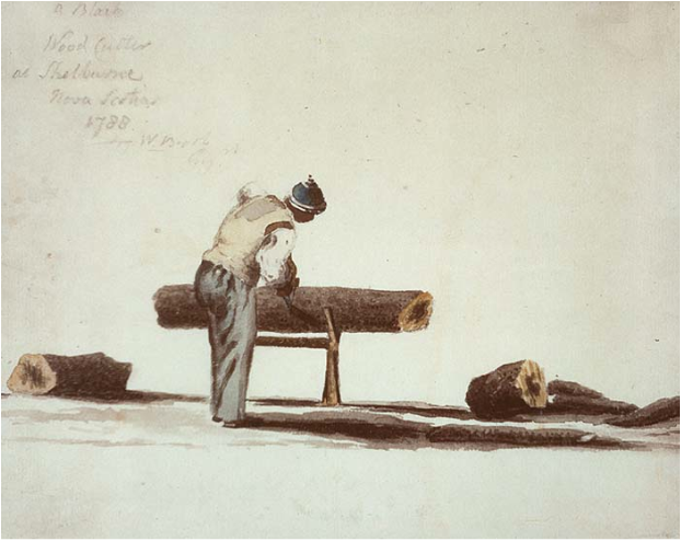
Editorial
The following article is an editorial written by The Canadian Encyclopedia staff. Editorials are not usually updated. “Freedom and a Farm.” The promise was exciting to the thousands of African Americans, most seeking to escape enslavement, who fought in British regiments during the American Revolutionary War (1775–83). Following the war, they joined tens of thousands of Loyalists — American refugees who had sided with the British. Between 80,000 and 100,000 Loyalists eventually fled the United States. About half came to British North America. The main waves arrived in 1783 and 1784. The territory that now includes the Maritime provinces became home to more than 30,000 Loyalists. Most of coastal Nova Scotia received Loyalist settlers, as did Cape Breton and Prince Edward Island (then called St. John’s Island).
"https://d3d0lqu00lnqvz.cloudfront.net/media/media/be13527b-b76d-408a-afca-30acbd4f7bfc.png" // resources/views/front/categories/view.blade.phphttps://d3d0lqu00lnqvz.cloudfront.net/media/media/be13527b-b76d-408a-afca-30acbd4f7bfc.png
Article
In 1673, in order to develop the young colony of New France, Governor Louis de Buade de Frontenac gave large concessions of land to administrators, priests and high-ranking soldiers who became seigneurs. The seigneurie des Mille-Îles was created north of the river that bears the same name.
"https://d3d0lqu00lnqvz.cloudfront.net/media/media/f10e3371-4bbb-40a2-b591-f640fdca2af3.jpg" // resources/views/front/categories/view.blade.phphttps://d3d0lqu00lnqvz.cloudfront.net/media/media/f10e3371-4bbb-40a2-b591-f640fdca2af3.jpg
