Share on Facebook
 Share on X
 Share by Email
 Share on Google Classroom
There are 207 reserves in Ontario, held by 127 of Ontario’s 128 First Nations (see also First Nations in Ontario). (Beaverhouse First Nation, first recognized by the federal government as a First Nation in 2022, does not have reserve land.) In 2020, there were 221,822 registered Indians living in Ontario, about 44 per cent of whom lived on reserves. Reserves in Ontario are held by Anishinaabe, Cree, Oji-Cree, Haudenosaunee, Delaware and Algonquin peoples.
Geography
While all of Ontario is First Nations’ traditional territory, reserves make up less than 1 per cent of the province’s total land area. By comparison, Ontario’s provincial parks and other protected areas total over 9 per cent. At 426 km2, Ontario’s largest reserve is Wiikwemkoong, located on the east end of Manitoulin Island in Georgian Bay. As a point of comparison, London, Ontario is 420 km2.
Generally, Cree and Oji-Cree reserves dominate the northern reaches of Ontario. Saulteaux reserves are found east of Lake Superior, near the southern portion of the Ontario-Manitoba border. The Nipissing First Nation is located near the lake of the same name, in central Ontario. Chippewa, Ojibwe, Odawa, and Mississauga communities are located along the shores of the Great Lakes. Haudenosaunnee reserves are in the southwestern and eastern portions of the province. Other First Nations with reserves in Ontario are the Potawatomi of southern Ontario and eastern Georgian Bay, the Delaware and Munsee-Delaware peoples of southern Ontario, and the Algonquins of the Ottawa Valley. Some communities have more than one reserve. For example, the Batchewana First Nation has four: Goulais Bay, Obadjiwan, Rankin Location, and Whitefish Island. Additionally, 34 reserves — all located in Northern Ontario — are only accessible by air or winter roads.
Demographics

The majority of reserves in Ontario are held by Anishinaabe communities, followed by Cree, Haudenosaunee, Delaware and Algonquin. The largest reserve population in Ontario is Six Nations of the Grand River. In 2021, there were 28,019 members of this Haudenosaunee community, 12,849 of whom lived on reserve. The Mohawks of Akwesasne have the second largest on-reserve population: Of their 12,964 members (2021), 10,120 live on reserve.
Treaties
Before the arrival of Europeans, First Nations hunted, gathered, and farmed throughout Ontario and the surrounding region. When Europeans began arriving in the early 1600s, First Nations participated in the fur trade and at times warred over access to resources — for example, during the Iroquois, Fox and Dakota wars. From their arrival in Ontario, Europeans sought to create alliances with First Nations through treaties; however, it wasn’t until the 1850s that treaties began to include the concept of reserves. Up until that point, treaties did not mention reserves, although land for the First Nation signatories, along with money and other gifts, was often included as part of the deal. These lands eventually became a part of the reserve system following the creation of the Indian Act in 1876.
The first treaties in Ontario that directly led to the creation of reserves were the Robinson-Huron and Robinson-Superior treaties of 1850. Known collectively as the Robinson Treaties, these agreements were signed with Ojibwe communities along the northern shores of Lakes Huron and Superior.
Treaties in Ontario continued to be signed, and continued to include reserves, until 1923 when Canada stopped making treaties. Agreements created during this period were Treaties 3, 5 and 9, signed with Ojibwe and Cree communities in northern Ontario, and the Williams Treaties (the last to be signed in both Ontario and Canada) with the Chippewa of Lake Simcoe and Lake Huron, and with the Mississauga of the North Shore of Lake Ontario and central Ontario.
There are several First Nations in Ontario who live on unceded land, meaning that they never gave their territory to the federal government. These First Nations include the signatories of the Robinson Treaties. Unlike the treaties that came after them, the Robinson Treaties did not involve the surrender of the land chosen by the First Nation signatories for their reserves.
By comparison, the numbered treaties required First Nations to select reserves from the land that they were giving up. In addition to signatories of the Robinson Treaties, some First Nations live on unceded land because they refused to sign treaties. Wiikwemkoong First Nation, for example, refused to sign the 1862 McDougall Treaty, which dealt with Anishinaabe land on Manitoulin Island. Under the Indian Act, all land set aside for the use of a First Nation is treated as a reserve, regardless of whether it is on ceded or unceded territory. However, the fact that these lands were never surrendered is an important distinction for the communities involved.
Did you know?
Indigenous children in Ontario, as in all provinces and territories in Canada, attended residential schools. Some of these schools were located on First Nation reserves, as was the case for St. Mary’s Indian Residential School. It was located on Wauzhushk Onigum Nation’s reserve, near Kenora, Ontario. Between 1948 and 1953 the federal government conducted nutritional experiments at St. Mary’s and five other residential schools across the country. These experiments were among the many abuses suffered by residential school survivors.
Land Claims
Land claims, also known as modern treaties, began after 1972. Land claims attempt to address the rights of Indigenous Peoples who didn’t sign treaties, such as Wiikwemkoong First Nation, as well as the grievances of First Nations who did sign treaties but didn’t receive what they were entitled to (see Comprehensive Land Claims: Modern Treaties and Indigenous People: Specific Land Claims ).
There are many examples of First Nations in Ontario who have used the land claims process as a means of addressing treaty wrongs. Gull Bay First Nation, for example, located on the western shore of Lake Nipigon, thought the Robinson Superior Treaty promised them a reserve that measured 16 square French leagues. The French league was a distance measurement they had learned from French fur traders. Instead they received a reserve that measured 16 square miles. This type of misunderstanding was a problem with all of the Robinson Treaties. While the treaties included descriptions of reserve lands measured in miles, First Nations assumed the land would be measured in French leagues, the only European unit of measurement known to them. Since a league was about two and a half times the size of a mile, the reserves were significantly smaller than what First Nations believed they had agreed upon. Problems also arose when surveyors and First Nations had difficultly locating the borders of reserves as they were described in the treaties. In addition, the surveyors, with the assistance of land and mining speculators, made sure reservation borders excluded areas that were already settled or that had valuable mineral resources. In 2016, Gull Bay First Nation filed a land claim, asking for $150 million in compensation for the years of lost income from mineral extraction and forestry had the reserve been the proper size.

The land claims process has also created entirely new reserves for specific nations. Missanabie Cree First Nation, for example, was promised a reserve in 1906 under the terms of Treaty 9. However, the lands promised were never surveyed or set aside for this Cree community. In 1993, Missanabie Cree First Nation filed a land claim asking for the reserve lands entitled to them. In 2010, 104 years after Treaty 9 was signed and 17 years after the land claim was filed, the Ontario government set aside about 39 km2of land northeast of Sault Ste. Marie. In 2018 the land became a reserve.
First Nations throughout Ontario, such as the Six Nations of the Grand River, Fort Severn, Moose Cree, and Walpole Island, continue to negotiate with Canada to settle outstanding claims relating to the loss and return of reserve lands.
Governance
Reserves in Ontario, like in other provinces, are governed by chiefs and councils. The size of the government and the length of their time in office differs from First Nation to First Nation. Many are governed according to the Indian Act, which provides one chief as well as one councillor for every 100 members of the First Nation. The chief and councillors are elected every two years.
However, the majority of First Nations in Ontario use what the federal government calls a “custom” form of governance. This means that the First Nation has more choice as to what their leadership selection process looks like. Under custom systems, chiefs and councils are often elected for longer terms. Six Nations of the Grand River, for example, elects a chief and nine councillors every four years. In addition to this system imposed by the Indian Act, Six Nations of the Grand River also continues to employ their traditional Confederacy Council governance system.
The First Nations Elections Act also allows for longer terms. Introduced in 2014, the Act does not replace the Indian Act or custom governance systems. Instead, it allows bands to opt into a modified form of the Indian Act’s electoral system. As of 2020, eight Ontario First Nations have adopted this form of governance.
In the late 1800s and through the 1900s, the federal government interfered with the internal affairs of First Nations. For example, they removed chiefs and imposed electoral processes. These efforts caused significant damage to many communities. Recently, the federal government has been more accepting of First Nations forms of governance. In addition, many communities have taken significant steps to renew and restore their traditional systems of government, at the local level as well as at the level of Nation.
Challenges
People living on reserves in Ontario often face challenges unfamiliar to their non-Indigenous neighbours. These may include lower levels of education, fewer economic opportunities, and inadequate housing. There are further disparities when comparing reserves geographically: reserves in the southern portion of the province tend to be better off than reserves in the north. While government funding for reserves is the same regardless of location, reserves in the south are closer to large urban centres, providing them with greater employment and educational opportunities.
In addition, reserves in the north, in particular air-access-only communities, tend to face housing crises in a way more southerly reserves do not. On 28 October 2011, for example, Attawapiskat First Nation, located on the eastern shore of James Bay, declared a state of emergency due to a housing crisis. As of the spring of 2018, 50 new homes had been built; however, it’s estimated the community will need 595 new homes by 2030. Similarly, long-term boil water advisories tend to affect reserves in Northern Ontario more frequently than they do those in the south. (A boil water advisory signals when water is unsafe to drink or to use for personal hygiene. The federal government defines “long-term” as an advisory that’s been in place for a year or more.)
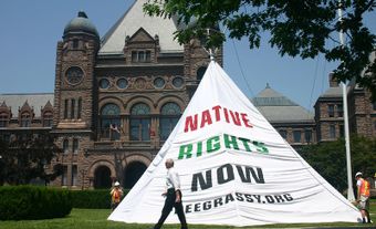
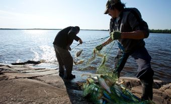
Environmental pollution has also impacted the health and well-being of communities. For example, the people of Grassy Narrows have seen their Indigenous lifestyle destroyed by mercury contamination of their river system. This contamination decimated their food fishery and has negatively impacted generations of people’s health and wellbeing. Grassy Narrows is still seeking proper remediation of the continuing mercury pollution of their community. Similarly, Serpent River First Nation has been affected by nuclear waste contamination from the former uranium mines in Elliot Lake, a town north of the reserve. The reserve lands and people’s health were also affected by a sulphuric acid plant built on the community’s land. The plant was meant to employ local First Nations and supply the product to the Elliot Lake mines. After a lengthy process, the federal government agreed to clean up the sulphuric acid plant in 1988-89. The land then became the reserve’s powwow grounds. When it was later discovered that moccasins were being eroded from remaining sulphuric acid, the pow wow grounds were moved to a higher elevation. The community is again (2019) negotiating for another site cleanup.
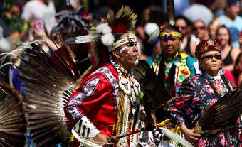
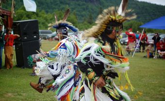
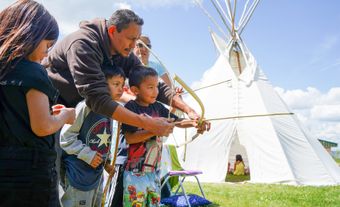
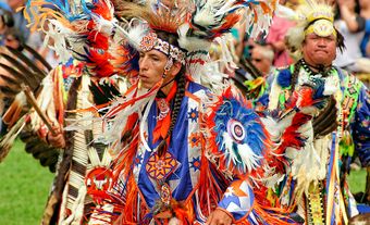
Arts and Culture
Reserves in Ontario have produced many famous actors, artists and athletes. Well-known actors include Jay Silverheels, from Six Nations, who was famous for his role as Tonto on the Long Ranger (1949-57). Graham Greene, also from Six Nations, is known for his roles on the television series the Red Green Show (1991-2006), as well as for movies including Maverick (1994), Dances with Wolves (1990) and Clearcut (1991).
Famous artists include Norval Morrisseau from Sand Point First Nation (now Bingwi Neyaashi Anishinaabek First Nation). Morrisseau created the Woodland School of Art and is a member of the Indian Group of Seven. Morrisseau’s art drew on his Anishinaabe culture for inspiration, leading to bright and vibrant works that were recognized around the world. Another member of the Indian Group of Seven is Daphne Odjig from Wiikwemkoong First Nation. Much of her work explores Anishinaabeg myth and history as well as the importance of relationships among all life.
Well known athletes include Tom Longboat (Six Nations) for running, Ted and Jordan Nolan (Garden River) for hockey, and Tara Hedican (Eabametoong) for wrestling.