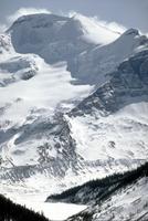
Astride the Continental Divide, it lies at the hydrographic apex of North America. Called the "mother of rivers," its meltwaters nourish the North Saskatchewan, Columbia, Athabasca and Fraser river systems. It contains about 30 distinct glaciers, the largest being Saskatchewan and Athabasca. A vestige of the great ice shield that once lay over most of Canada, the Columbia Icefield is the largest accumulation of ice in the Rocky Mountains, covering some 230 km2 of snow and ice to a depth of 365 m. Tree-ring studies show that the icefield advances and recedes in cycles, the latest advance having occurred around 1840. It has been receding throughout the 20th century.
The icefield is a spectacular sight of undulating white, soaring rock peaks and deep ice caverns. Castleguard Cave runs for 23 km beneath it. At its south and north faces, it drops off into forested valleys. It can be reached from the Icefields Parkway, a scenic road connecting Lake Louise and Jasper, and can be climbed by experienced mountaineers to its crest, called the Snow Dome (3520 m), from which point its waters are said to melt into 3 oceans.

 Share on Facebook
 Share on X
 Share by Email
 Share on Google Classroom


