Share on Facebook
 Share on X
 Share by Email
 Share on Google Classroom


")
")
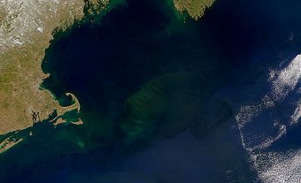
The Bay of Fundy and Gulf of Maine, with a total area of about 180 000 km2 and depths of generally less than 200 m, are a part of the Continental Shelf off eastern Canada and New England. The Bay of Fundy and Gulf of Maine marine ecosystem is a macro-tidally influenced, semi-enclosed coastal sea, terrestrially bounded by 3 northeastern US states (Maine, New Hampshire and Massachusetts) and 2 Canadian Maritime provinces (Nova Scotia and New Brunswick). The area of the Bay of Fundy alone is about 16 000 km2. Its name is likely a corruption of the French fendu ("split"). It was known for a time as La Baie (or Baye) Françoise.
Between about 15 000 and 10 000 years ago, as the glaciers retreated from the last ice age, parts of Georges Bank and other shallow areas were dry land; fragments of trees and mammoth teeth from this era are still found occasionally in fishing trawls. A rising sea level since then not only submerged these offshore banks, but also led to the development of the present tidal regime.
Tides
The tides of the Bay of Fundy are the world's largest, with a range from low to high tide that can exceed 16 m in Minas Basin at the head of the bay. The highest recorded tide (16.1 m) was at Burntcoat Head, NS. At peak flood tide, the flow of water across the edge of the continental shelf into the Gulf of Maine is 25 million cubic metres per second, 2000 times the average discharge of the St. Lawrence River. The flow past Cape Split into Minas Basin is 40 times that of the St Lawrence.

The main reason for these large tides is that because of its shape, size and depth, the Bay of Fundy and Gulf of Maine system has a natural period of oscillation of about 13 hours. As a result, its waters respond vigorously to the push they get every 12.4 hours from the North Atlantic tides - a phenomenon known technically as a near-resonant response. The Reversing Falls at Saint John, NB, and the tidal bores in rivers near the head of the bay are well-known natural phenomena associated with the tides.
The large tides also have dramatic effects on oceanographic conditions throughout the region. Large areas, such as Georges Bank, much of the Bay of Fundy, and the area off southwest Nova Scotia, are kept well mixed vertically by the strong tidal currents (with resulting cold surface waters and frequent fog), rather than developing the warm surface layer that occurs in less well-mixed waters in summer. The tides also contribute to the average circulation patterns in the region.
The combination of strong tidal currents and complex bottom topography results in tidal rips, whirlpools, upwelling and intense mixing throughout the region. These effects influence biological productivity, generally favourably, by returning nutrients to surface layers where they can be utilized. The region's unique topography and oceanographic conditions combine to promote highly productive phytoplankton and zooplankton populations that support high fish production. Thus, the waters off southwestern Nova Scotia form the summer feeding ground of the Nova Scotia herring, a major stock of several hundred thousand tonnes. Off Brier and Grand Manan islands, where tidal currents interact with the sharp topographic relief, swarms of copepods and euphausiids (or krill) are often found at the surface. This condition attracts finback and humpback whales, along with large flocks of plankton-feeding birds such as phalaropes, shearwaters and gulls. The high primary productivity also results in the abundance of other predatory species, such as harbour porpoises and seals that prey on fish.
In areas around the islands in the outer Bay of Fundy, where the tidal currents combine with the complex bottom topography, there are highly diverse benthic communities including sponges, sea squirts, sea potatoes and sea cucumbers (see also Echinodermata).
In the bay's upper reaches the strong tidal currents keep so much mud in suspension that light penetration, and hence biological productivity in the water, are greatly reduced. Most of the biological productivity occurs on the mud flats, which are important feeding grounds in late summer for the vast flocks of migrating shorebirds, particularly semipalmated sandpipers.
Resources
The region's fisheries, particularly for scallops and groundfish on Georges Bank, for herring and lobster off southwestern Nova Scotia and for herring in the Bay of Fundy, are of great importance to many small communities, and indeed to the general economy of Nova Scotia, New Brunswick and the New England states. New developments are largely centred around fisheries and energy. Considerable effort is being devoted to research and international diplomatic activity to permit sensible regulation of the fisheries. The problem has been particularly acute on Georges Bank, where the US and Canada disputed the location of the international boundary and the setting and sharing of quotas for the various fisheries, and where exploratory drilling for oil and natural gas, with attendant risks to the fisheries, has occurred. Even with the October 1984 boundary decision by the International Court at The Hague, joint management of migratory fish stocks is required. A moratorium on petroleum development was put into place in 1988 and is currently still in effect.
Tidal Energy
One major possible development in the upper reaches of the Bay of Fundy is of tidal power. Schemes with a power output equal to that of several nuclear-power stations are technically feasible; a small pilot plant has been built in Nova Scotia's Annapolis Basin (see Tidal Energy). Surprisingly, these large schemes may lead to a slight increase in the tidal range over much of the Bay of Fundy-Gulf of Maine outside the barrage. In the head pond behind the barrage, the operation of the plant would lead to a substantial change in low-tide level and to a reduction of the tidal range, and hence of currents, by a factor of about 3. The possible effects of such a change on the extent and biological productivity of the mud flats, and hence on migrating shorebirds, are not yet fully understood.
More recent developing tidal technology does not require any dams or head ponds but floating tidal turbines and turbines that are anchored to the ocean floor. Based on an assumption that 15% of the tidal energy could be extracted without causing significant environmental impacts, 7 potential locations were identified in the Bay of Fundy for tidal energy extraction. Both Nova Scotia and New Brunswick are in the process of allowing the deployment of in-stream tidal energy devices. In January 2008, Nova Scotia authorized a tidal power demonstration and research facility for the testing of in-stream turbine devices in tidal waters of the Minas Basin. The area has a high potential for tidal energy generation with the mid-tide flow in the Minas Channel being equal to the combined flow of all the rivers and streams on Earth.