Share on Facebook
 Share on X
 Share by Email
 Share on Google Classroom
Prince Edward Island is part of the Appalachian region, one of Canada’s seven physiographic regions. The island extends for 224 km, with a width ranging from 4 to 60 km. It is known for its reddish-brown soil, so-coloured due to high concentrations of iron oxides.

Geology
Prince Edward Island’s landmass is young in geological terms. Freshwater streams created an enormous sedimentary basin underlying the present-day Gulf of St. Lawrence. These streams drained ancient highlands. The ice ages left an imprint on the land, especially during the late Pleistocene period between 75,000 and 10,000 years ago. When the last glaciers receded they uncovered what is now PEI. The glaciers left debris and scouring marks on the exposed land. Gradually, the land assumed its present character. A low plain covering much of the present-day Northumberland Strait connected the island to the mainland. This plain existed because of lower ocean beds and land depressed by the glaciers’ weight. As glaciers melted and ocean levels rose, the land also rebounded, and the crescent shape of the island emerged about 5,000 years ago.
Surface

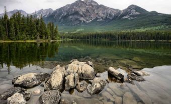
Prince Edward Island’s land surface ranges from nearly level in the west to hilly in the central region, and to gently rolling hills in the east. The highest elevation is 142 m in central Queens County.
The island's predominant reddish brown sandy and clay soils are occasionally broken by outcroppings of sedimentary rock. This sedimentary rock is usually red-coloured sandstone or mudstone. The heavy concentrations of iron oxides in the rock and soil give the land its distinctive reddish-brown hue.
The coastline is deeply indented by tidal inlets. The north shore of the island, facing the Gulf of St. Lawrence, features extensive sand-dune formations. These shifting sands pose problems for fishermen by clogging harbour entrances, but they provide a haven for summer tourists.
The shoreline of the island generally alternates between headlands of steep sandstone bluffs and extensive sandy beaches. Dredging tidal runs created many of the island's harbours. These harbours are usable only by vessels of shallow draught, such as inshore fishing boats. A few harbours, such as those of Summerside, Charlottetown, Georgetown and Souris, provide access and shelter for larger vessels.
Little is left of the province’s original forests. Three centuries of clearing for agriculture and shipbuilding, as well as fire and disease, have radically transformed them. During the 19th century, the upland areas of the province were forested with beech, yellow birch, maple, oak and white pine. Today, many of these woodlands have deteriorated into a mixture of spruce, balsam fir and red maple.
Climate
Prince Edward Island’s climate is moderate. Winters are long but relatively mild, and springs are late and cool. Summers are cool and marked by prevailing southwest breezes. Average mean maximum temperatures are approximately -3°C in January and February, and 23°C in July. The mean minimum temperature drops to approximately -26°C in January and February, and 14°C in July.
The island is relatively free of fog year-round, unlike neighbouring provinces. Annual rainfall is approximately 1,125.8 mm, while the annual snowfall is 318.2 cm. This precipitation ensures adequate groundwater supply. The waters of both the Gulf of St. Lawrence and Northumberland Strait are warmer in summer than the coastal waters of Nova Scotia and New Brunswick. In winter, ice covers both the strait and the gulf, and icebreakers are needed to keep shipping lanes open. Drift ice is often found in island waters as late as the latter part of May. The drift ice can make fishing difficult and slow the arrival of spring.
Conservation

Conservation is a major concern of government and public interest groups in the province. Wind and water have eroded some of the island’s best agricultural land. The reasons for this erosion include over-cropping, extensive mechanization, reliance on chemical fertilizers and removal of hedgerows. It is estimated, for example, that up to 5 tonnes of soil per hectare can be eroded from an unprotected plowed field in one year. This soil erosion has also led to heavy siltation of the creek and river systems. Because of siltation many streams, navigable in the last century, are now shallow and unusable.
Groups such as the Island Nature Trust have attempted to bring public attention to many of Prince Edward Island’s imperilled natural areas. However, most of the land is privately owned and vulnerable to inappropriate development, misuse or unwitting neglect.
The province is home to 21 provincial parks and one national park called Prince Edward Island National Park. The national park is located on the island’s north-central coast, and features sandy beaches as well as walking trails through Acadian forest.