Share on Facebook
 Share on X
 Share by Email
 Share on Google Classroom
Île d'Anticosti, 7,943 km2, 222 km long and 56 km at its widest point, is located in the Gulf of St. Lawrence, athwart the entrance to the St. Lawrence River. Though considerably larger than Prince Edward Island, its population is only about 200. In September 2023, the island was designated a UNESCO World Heritage Site.
Description
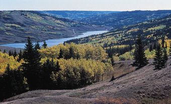
Most of the coastline is dominated by steep limestone cliffs, and several of its rivers cut through deep canyons. The eastern end is an enormous bog. Most of the inhabitants trace their ancestry to Newfoundland, Saint-Pierre and Miquelon, and the Îles de la Madeleine. Entirely French-speaking, they have made their living as fishermen, trappers, farmers, loggers and lighthouse keepers. In 1909, over 800 hectares were under cultivation, but no farms remain. The lighthouses are now all automatic.
History
Known by the Innu as Notiskuan ("where bears are hunted") and by the Mi'kmaq as Natigostec ("forward land"), it was explored by Jacques Cartier in 1534. He took it for a peninsula but later named it Île de l'Assomption. By the beginning of the next century, it was known as Anticosti. The island was granted as a seigneury in 1680 to Louis Jolliet in recognition of his exploration of the Mississippi River. After the fall of New France, it was annexed to Newfoundland, but in 1774 it was returned to Canada.
In 1872, a Montreal land company went bankrupt trying to colonize the island. In 1884, it was sold at auction for $101,000 to Francis Stockwell, an English businessman, who also went bankrupt trying to develop it. In 1895, Henri Menier, a millionaire French chocolate manufacturer, bought the island to develop as a private sports preserve. It was sold again in 1926 to Wayagamack Pulp and Paper Co (later integrated into Consolidated Bathurst Inc.), and a pulpwood industry flourished, more or less, particularly in the late 1920s, when the population rose to 3,000. These operations were shut down by 1972 because of transportation costs and forest fires.
The first permanent village was located at Baie-Ste-Claire. Menier developed it as a model town, but it was abandoned in the 1920s for Port-Menier, the only settlement on the island today. Outside Port-Menier lie the ruins of the island's once-famous landmark, Château Menier, a luxurious villa. It was deliberately burned down in 1953.
The island was bought by the Quebec government in 1974, and now more than 150 km2 of it is a wildlife reserve. The island has a rich variety of wildlife, the most notable being the more than 120,000 Virginia white-tailed deer ─ the progeny of 220 brought by Menier in 1896. Deer hunting is a main attraction.
Thousands of ships pass the island each year, and its treacherous reefs have given it the nickname "Graveyard of the Gulf. " It is estimated that some 400 ships have foundered on the reefs, most in the 18th and 19th centuries, before the establishment of lighthouses. Ships still run aground occasionally despite navigational aids.
A controversy broke out in 1937 when a group of Germans took out an option to buy the island and develop the forest industry. However, pressure from the federal and Québec governments aborted the attempt.
Present Day
The UNESCO World Heritage Committee designated the Island a UNESCO World Heritage Site on 19 September 2023 in Saudi Arabia. It was officially recognized for its geology and extensive fossil record of Earth’s history from 447 to 437 million years ago. This designation makes the island the third site in Quebec on the UNESCO World Heritage list, which includes the historic district of Old Quebec and Miguasha National Park.