Share on Facebook
 Share on X
 Share by Email
 Share on Google Classroom

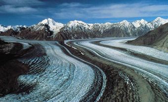
La Mauricie National Park (est 1977, 536.1 km2), first set aside in 1970, is situated about 220 km northeast of Montréal. The gently rolling Laurentian Highlands form a backdrop for the park's billion-year-old Precambrian granite and gneiss landscape, sculpted by the action of glaciers during the last Ice Age. The same glaciers scraped out the numerous lakes dotting the park. La Mauricie has a mixed forest vegetation. Coniferous species typical of the boreal forest share the hillsides with deciduous species found more abundantly in the St Lawrence Lowland. Wildlife includes moose, black bear, beaver, red fox and wolf. Some 111 bird species nest in the park. The lakes and bogs support 19 species of amphibians and reptiles.
The remains of red-ochre rock paintings testify that nomadic tribes hunted and fished here some 5000 years ago. Explorers and missionaries inhabited the area from the mid-1600s, but the lumber industry did not become established until the middle of the 19th century. The abandoned camps are a reminder of the colourful history of the lumberjacks and log drivers. Rivière Saint-Maurice until recently carried millions of logs to mills in nearby towns (they are now transported by truck).
La Mauricie's Laurentian heritage can be explored by canoeing, backcountry camping, hiking and cross-country skiing. Interpretive activities include guided walks, evening talks and canoe trips in voyageur canoes.