Share on Facebook
 Share on X
 Share by Email
 Share on Google Classroom
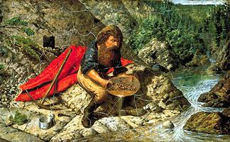

Prospecting
Exploration for new mineral resources began with the first use of metal (copper and gold) about 7000 years ago. In North America indigenous peoples used native copper before the arrival of Europeans in at least 2 areas: the Keweenaw Peninsula of Michigan on the southern shore of Lake Superior and the mouth of the Coppermine River.
The first organized mineral exploration by Europeans in what is now Canada was led by Martin Frobisher in his 3 expeditions to Baffin Island (1576, 1577 and 1578). Although his first expedition was directed primarily to finding a Northwest Passage to Asia, the much larger, privately financed, programs of 1577 and 1578 were largely prompted by the hope of finding gold ore. The program was a failure and the supposed gold ore brought back seems to have been schist or gneiss containing sparkling mica.
The next recorded prospecting venture, near the present harbour of St John's, Newfoundland, was instigated by Sir Humphrey Gilbert. In 1583 Gilbert brought out a Saxon miner, named Daniel, who prospected the shores and reported silver. No commercial deposits of any mineral were found, however, and both Gilbert and Daniel were lost on the return voyage.
In early French Canada, iron and silver were reported at St Mary's Bay, Nova Scotia, by Master Simon, a mining engineer accompanying Samuel de Champlain. In 1672, coal was discovered on Cape Breton Island by Nicolas Denys, who had been granted a concession in 1654 by Louis XIV to mine gold, silver, copper and other minerals. Iron ore was found near the mouth of the St Maurice River, Québec, and first smelted there in 1737 to produce iron metal. In 1770, Jesuit fathers experimented with native copper found at Port Mamainse, on the north shore of Lake Superior.
Not much prospecting appears to have been done by the employees of the Hudson's Bay Company. The exception was Samuel Hearne, employed by the HBC at Prince of Wales Fort near the present port of Churchill, Manitoba, who undertook a cross-country expedition to find the source of the native copper used by members of a northern native tribe. In 1771, after 2 unsuccessful attempts, Hearne reached the source of the copper on the banks of the Coppermine River near the Arctic Ocean. Apart from these expeditions, there was little deliberate search for metals in Canada from 1600 to 1800, except for a general alertness for mineral deposits shown by traders and trappers in their wilderness travels, especially through the Precambrian Shield. North West Company fur trader and explorer Alexander Mackenzie discovered coal on the Great Bear River, NWT, in 1789, and David Thompson discovered coal on the Saskatchewan River in 1800. Gypsum was mined in Nova Scotia as early as 1779 and coal discovered in New Brunswick near Grand Lake, where coal was first mined in 1782.
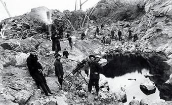
Lead was found near the Ottawa River and on the east shore of Lake Timiskaming in 1686, but this source was forgotten until 1870. The first Canadian discovery of copper to reach commercial production was at Bruce Mines on the north shore of Lake Huron; production began in 1848. Silver was found at Silver Islet, on the north shore of Lake Superior, in 1868 and mined there until 1884. The presence of nickel-copper near what became the Murray mine at Sudbury was discovered by accident in 1883 as a result of railway construction in the area.
The founding of the Geological Survey of Canada (1842) and of the geological departments of the Ontario Bureau of Mines (1891) and the Quebec Department of Colonization and Mines (1898) encouraged prospecting in these provinces. The Porcupine District of Ontario, which became Canada's most important gold mining area, was first noted as favourable for gold mineralization by W.A. Parks in his report to the Ontario Department of Mines (about 1900), and became the scene of a gold rush in 1909. The "Golden Mile" at Kirkland Lake, Ontario, southeast of the Porcupine, has been Canada's second most important gold mining area since its discovery in 1911, although the Hemlo gold deposit, discovered in 1981 east of Marathon, Ontario, is a rival for second place. In 1903 silver was discovered at Cobalt, Ontario, and in the following 2 decades the area became the world's chief silver producer.
In the meantime, prospecting had progressed from the West Coast into the valleys and mountains of BC. Placer gold first attracted prospectors north from earlier gold rushes in the western US in the mid-19th century, with the Cariboo gold district of central BC discovered in 1859. In 1896 the discovery in the Yukon of placer gold on the Klondike River and its tributaries led to the most extensive gold rush in Canadian history (see Klondike Gold Rush). In BC, prospecting for lead, silver and copper began in the 1880s. Several base-metal mines were active in that province. The Sullivan Mine near the Slocan River, still a large producer of lead and silver in the mid-1990s, was discovered in 1893.
During this period, prospecting, aided by the GSC, was carried on in the Eastern Townships of Québec, south of the St Lawrence River. Placer gold had been found in the area earlier in the Chaudière River, but had yielded only limited production. By the end of the 19th century, interest had extended to copper and, later, to asbestos. In northern Québec, copper was first noted in the Chibougamau area in 1870, but it was 25 years before this discovery resulted in widespread prospecting. From the 1860s, there was vigorous prospecting for gold in eastern Nova Scotia that resulted in the establishment of many small-scale gold mines, but the total gold production from Nova Scotia mines has not been large. By 1920, prospecting was active in some parts of all provinces (except Prince Edward Island) and, since the end of WWII, prospecting, now described as mineral exploration, has occupied a significant part of Canadian expenditures on natural resources.
Aids to Prospecting
Geology
Until after WWII, prospecting in Canada and elsewhere depended essentially on the use of the pick and shovel by individual prospectors guided by some knowledge of geology. Prospectors chose areas for exploration aided by geological maps prepared and distributed by the GSC and by geological surveys of the various provinces. Almost all of the metallic mineral deposits in Canada occur in 3 main geological areas: the mountainous belt of BC and the Yukon affected by the Cordilleran folding from 230 to 50 million years ago; the Precambrian Shield, extending from the Labrador Coast west to northern Saskatchewan and north to the Arctic coast, which has rocks and periods of folding and intrusion dating from as long as 4 billion years ago to as recently as 570 million years ago; and southeastern Québec, New Brunswick, Nova Scotia and Newfoundland, all of which were affected by periods of Appalachian folding of 470-320 million years ago. Each geological region has its own mineral characteristics and prospecting targets.
Recent Exploration Success
Over the 40-year period from the mid-1950s to the mid-1990s, it has become increasingly difficult, and much more costly, to discover new metal ore bodies in Canada, despite the successful application of increasingly more sophisticated and effective exploration techniques. Many more Canadian metal ore bodies remain to be discovered, but many of them will be difficult to find.
The large and high-grade Voisey's Bay nickel-copper-cobalt ore body, the third most important Canadian nickel discovery ever after the Sudbury and Thompson districts, was found in 1994 by prospectors who were searching for diamonds, and who landed their helicopter to check a rusty mineralized outcrop observed from the air. This important mineral discovery was made by methods little more sophisticated than those used in the chance discovery of a rusty outcrop in 1883 that resulted in the unearthing of nickel-copper ore bodies of the Sudbury District. That Voisey's Bay and other recent Canadian ore bodies were discovered by simple prospecting rather than by more sophisticated methods make it clear that the day of the individual prospector has not come to an end.
Geophysics
Since 1946 there has been an increasing use of geophysical techniques (see physics) in mineral exploration. This trend has coincided with an increased proportion of mining exploration conducted by individual companies and company joint ventures, as contrasted with that by individuals or small groups of prospectors. The first application of geophysics was the design and use of the dip needle and its successor, the magnetometer. The latter instrument, first developed in Sweden in the latter part of the 19th century, measures the relative magnetic attraction of different parts of the Earth's surface (see magnetic pole). Magnetite (magnetic iron oxide) gives the strongest magnetic pull of any mineral, but sulphide-nickel ore contains the magnetic form of the mineral pyrrhotite, so it also has above-average magnetic intensity and, under soil or rock covering, presents a suitable target for the magnetometer.
In Canada, Thomas Edison, the American inventor, was the first recorded user of the magnetometer on nickel. Near Sudbury, Ontario, shortly after WWI, he noted a strong magnetic anomaly between 2 known nickel-copper deposits on the projection of the same geological contact, but in an area covered by a thick layer of gravel. The shaft sunk on the indicated location did not go deep enough and it was not until some years later that deeper investigations proved the existence of the ore body that had given the magnetic indication. The magnetometer was also used before WWI in areas known to have iron formations, which are strongly magnetic, in Ontario and Québec. Its use became widespread in the 1930s, both for the direct indication of magnetic ores and for tracing geological contacts under surface covering.
In Canada, in the late 1920s, geophysics was also applied to prospecting in the measurement of earth voltages. It was discovered that naturally occurring weak electric currents flow between rock formations having different electrical charges. These electric currents are stronger in the vicinity of metallic sulphide bodies and produce a measurable voltage or self-potential. They essentially constitute a large battery, the current flow from which can be detected through shallow soil cover. The use of electrical measurements then moved to the introduction of artificial currents into the ground by one set of current electrodes and the measurement of the subsequent voltage variations in the ground by a second set of measuring electrodes. The resistivity method, as this technique is called, measures the degree of resistance the ground has to electrical current flow. Metallic minerals in the earth are good electrical conductors and have low resistance, whereas barren rocks have high resistance.
A further development was the indirect energization of the ground by a primary alternating current using a powerful transmitting coil. Around natural conductors, such as metallic ore bodies, a secondary electrical field is produced by the primary electrical field. These secondary electromagnetic fields can be detected by a receiving coil much like a radio receives a station signal from a remote transmitter. The variation in the signal strength is an indication of conductive differences in the underlying ground and rock composition. Using the electromagnetic method, conductive metallic mineral concentration can be detected through thick earth and rock cover.
These developments took place prior to WWII, but it was not until the 1950s when advances in electronics and instrumentation made the electromagnetic method a major and successful tool for prospecting for hidden orebodies. At this time, both magnetic and electromagnetic equipment were installed in fixed-wing aircraft and used in systematic air surveys, thus increasing production and ground coverage. As the electronic equipment for these airborne systems became smaller and lighter and navigation systems improved, they could be installed in helicopters for use in rugged terrain, such as in BC and the Yukon.
Airborne geophysical methods cannot define the location of a conductor or magnetic body with sufficient accuracy to allow direct testing by drilling. Normally, when an anomaly is noted by airborne techniques and selected for investigation, a ground party is sent in to prospect the area by conventional methods and to confirm and more accurately locate the airborne indications by ground geophysical techniques. The first discovery in Canada of an ore body by means of airborne electromagnetic methods, in 1952, was the one that became the Heath-Steele Mine, New Brunswick. From 1950 to 1959, 19 of a total of 59 Canadian discoveries resulted initially from indications collected by airborne geophysical methods. The most important such discovery took place in 1963 and became the Kidd Creek Mine, near Timmins, Ontario, one of the largest and richest base-metal mines in the world.
In the late 1950s, as a result of advances in electronic measuring techniques, the resistivity technique was further developed. Up to this time, discrete metallic mineral particles within rock that were not electrically connected could not be detected using conventional electrical methods. From laboratory experiments, however, it had been shown that metallic mineral particles disseminated throughout a rock, if energized electrically, become charged particles for short periods and, as a whole, act like a capacitor or condenser to store electricity. Over a period of time, these charges dissipate into the ground. By measuring the voltage of the ground at 2 different very low electrical frequencies, this capacitive effect could be calculated.
The induced polarization measurement, as this method is called, can also be made by energizing the ground and then turning the current off very quickly and measuring the decay time of the voltage. Certain types of base and precious metal orebodies, such as the porphyry copper/molybdenum ore deposits of BC, are associated with disseminated metallic minerals. Such ore bodies do not constitute electrical conductors. The application of the induced polarization method was a major breakthrough in the detection of such ore bodies hidden by overlying earth or rock. More recently, this method has been instrumental in assisting in the discovery of gold deposits. Because gold ore contains only minute quantities of the minerals, it is not directly detectable by geophysical methods but is commonly associated with disseminated metallic minerals that can be detected.
With the growing interest in uranium following WWII, instruments to measure radioactivity, such as the Geiger counter and later the much more sensitive scintillometer, became important prospecting aids. Many discoveries, especially in northern Saskatchewan, have resulted from tracing trains of radioactive boulders, plucked from their source by glaciers in the Pleistocene Ice Age and distributed in a rough line in the direction of the ice movement. Measurement of the radioactivity of waters of lakes overlying radioactive deposits has also led to discoveries. Radioactive measuring techniques have become increasingly accurate and sensitive. The use of radioactive measurements from aircraft is now routine and the GSC, in collaboration with some provincial surveys, has carried out such surveys in a reconnaissance fashion over much of the Precambrian Shield.
The Geiger counter and scintillometer are unable to distinguish between radioactivity emanating from uranium, thorium, potassium and other radioactive elements and isotopes. More recently, the development of a more sophisticated radiation detector, the gamma ray spectrometer, has made it possible to distinguish between the various energy levels of radiation emitted by specific radioactive elements and isotopes, and thereby to detect deposits of specific radioactive elements, not merely measure the radioactivity produced by unidentified elements.
Geochemical Prospecting
Various geochemical methods have been developed since the 1950s and used in exploration for mineral deposits. As mineral deposits are weathered, they release quantities of the metals and other elements they contain to the surrounding environment. These metals can be contained in groundwaters or in soils, and metals can be precipitated from the groundwater and thereby enriched in the soil, depending on the chemical environment, the oxidation-reduction potential and the acidity and alkalinity (pH) of those soils. They can also be taken up and concentrated by plants that utilize the metal-containing groundwaters, thereby concentrating the contained metals in plant tissues.
Geochemical surveys can be carried out by gathering and chemically analyzing samples of soils, stream sediments, lake waters and lake-bottom sediments. Biogeochemical surveys can be carried out by taking samples and chemically analyzing various plant species, eg, the tips of spruce tree branches.
Areas of anomalously high metal contents (measured, in the case of stream sediments, in parts per million) may indicate the presence of metal deposits nearby or upstream. In the case of stream sediments, geochemical anomalies can also result because local oxidation-reduction and pH conditions in the stream are such as to precipitate out and concentrate the trace quantities of metals present in the stream waters as they flow past. Such anomalies are not necessarily indicative of the presence of metal deposits nearby, but may provide clues as to the presence of metal deposits nearby. Also, geochemical anomalies may only indicate the presence of extensive areas of rock types that have unusually high background levels of the metals being tested for, but without the presence of any mineral deposits of interest.
Geochemical prospecting methods can be useful prospecting methods under some circumstances, but the outlining of strong geochemical anomalies does not necessarily lead to the discovery of commercial orebodies.
Heavy Mineral Prospecting
Canada has been extensively glaciated, with flowing glacial ice having abraded the surface of mineral deposits and carried away grains of gold, diamonds and other minerals. Sampling of glacial gravels deposited by the Pleistocene continental ice sheet, taken using small test pits, shovels or overburden drilling, and the preparation of heavy mineral concentrates from such samples, is a useful prospecting method. The heavy mineral fraction can be examined using a microscope to search for grains of valuable heavy minerals such as gold and diamond, or to search for grains of specialized types of the 3 diamond indicator minerals ilmenite, pyroxene and garnet. These varieties of ilmenite, pyroxene and garnet occur only in kimberlite, the rock-type in which diamonds may be found, but not in other types of igneous rocks.
When heavy minerals of interest are located, additional samples can be taken in the up-ice-flow direction (the direction from which the glacial ice has come) as indicated by glacial striations (glacial scratches) on rock outcrop surfaces. Where concentrations of the heavy minerals of specific interest are no longer found in an up-ice-flow direction, the mineral deposit from which they have originated must lie somewhere in the down-ice-flow direction. Appropriate exploration methods, such as geophysical surveys or exploration drilling, can then be used to continue the search for an ore body when such target areas have been located.
Heavy mineral prospecting was successfully applied in Canada during the 1980s and 1990s in the discovery of a number of gold and diamond ore bodies.