Share on Facebook
 Share on X
 Share by Email
 Share on Google Classroom
There are two reserves in the Northwest Territories. In addition, of the territory’s remaining 32 communities, 28 have a majority Indigenous population. Dene, Inuvialuit and Métis people are the primary Indigenous groups living in these communities. The territory’s two reserves are Hay River Dene 1, held by the Kátł’odeeche First Nation, and Salt River No. 195, held by the Salt River First Nation (see also First Nations in the Northwest Territories). The Northwest Territories differs from much of southern Canada, where several provinces have hundreds of reserves, and where large percentages of First Nations people live in these communities. While Treaty 8 and Treaty 11 — which taken together cover most of the territory — provided for reserves, none were created in the years immediately following their signing. The reasons for the limited number of reserves in such a large region are rooted in a complicated history.

Geography
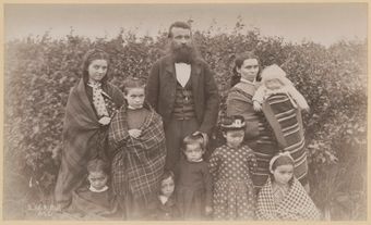
The Northwest Territories’ two reserves, Hay River Dene 1 and Salt River No. 195, are both located in the southernmost part of the territory, just north of the Alberta border. The Hay River reserve consists of approximately 130 km2 along the eastern shore of the Hay River near its outlet at Great Slave Lake. This region has always been an important transportation and communications hub, both before the arrival of Europeans and since. It was recognized as a gathering place by the Hudson’s Bay Company when it established a fur-trade post there in 1868. Missions operated by the Roman Catholic and Anglican churches followed. American fur traders arrived in 1870 to compete with the Hudson’s Bay Company (some of the earliest competition in the north).
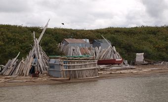
Salt River No. 195 is one of the most unusual reserves in Canada because it is not a single block of land. Instead, it consists of a total of 414 km2 in separate parcels west and north of Fort Smith, including lots in the town of Fort Smith itself and 13 km2 in Wood Buffalo National Park (part of which is located in Alberta). The Salt River First Nation takes its name from the Salt River, a tributary of the Slave River. The Slave River is an important transportation route in the north. The region has always been a meeting place of peoples, including those who make up the Salt River First Nation, a branch of the Dene-Chipewyan called the Dedharesche.
Demographics

The Hay River reserve is home to members of the Kátł’odeeche First Nation, who are part of the Dehcho people (also known as the South Slavey). In 2021, the reserve’s population was 231. The Salt River First Nation includes both Dedharesche and Cree. Unlike many reserves, where members of a First Nation live on reserve land, very few members of Salt River First Nation live on the parcels of land that make up their reserve. Instead, the Salt River First Nation is based in the town of Fort Smith, and counts members living around the world. In 2021, Salt River First Nation had 1,023 registered band members.
Both the Dehcho people of the Hay River reserve and the Dedharesche people of the Salt River First Nation belong to an ethnic group known as the Dene. Dene means “people” and refers to a group of culturally related Indigenous peoples. They speak languages that linguists group into the Athapaskan language family (see Indigenous Languages in Canada). Names used by outsiders, such as Slavey, Dogrib, Hare, Chipewyan and Loucheux, have been replaced by the names preferred by the people themselves. Regional groups are now known as Dehcho, Sahtu Dene and Gwich’in.
Treaty 8 and Treaty 11
Most of the Northwest Territories is covered by Treaty 8 and Treaty 11, signed between the Government of Canada and representatives of some Dene First Nations. These treaties are part of the series known as the Numbered Treaties.
In 1898, prompted by the discovery of gold in the Klondike two years earlier, the Canadian government began to arrange Treaty 8 with the First Nations of the valleys of the Peace, Athabasca and Nelson rivers. The government wanted to promote this area as an “all-Canadian” access route to the goldfields. Although there was a clause in Treaty 8 requiring reserves to be created, treaty commissioners encountered strong resistance to the idea. No further action was taken on the subject.
In 1913, government officials began their first survey of the Athabasca-Mackenzie region; however, the intention of the survey was not to identify sites for reserves. Instead, surveyors were to identify First Nation and non-First Nation settlements, so as to avoid disputes with incoming settlers. Many First Nations took issue with the ways in which the surveyors chose to define their land, while others rejected the notion of a survey entirely. At Fort Smith, however, a group of Chipewyan-Dene (ancestors of the Salt River First Nation) were concerned about the growing non-Indigenous population there. In 1916, they asked for three reserves in the area. At the same time, the government was making plans for what would become Wood Buffalo National Park. Nothing came of the group’s request for reserves, in part because the government wanted to prevent conflicts about overlapping land use.

A second treaty was put in place following the discovery of petroleum deposits near Fort Norman. In 1921, Treaty 11 was signed with representatives of Dene communities along the Mackenzie River, between the southern border of the NWT and the Arctic Ocean. Again, the treaty included a clause about the creation of reserves, again in spite of Dene resistance to the idea. And once again, no further action was taken to create reserves.
After the Second World War, interest in northern resource development raised questions about the fact that not all the provisions of Treaties 8 and 11 had been fulfilled. Most obviously, there were no reserves. In 1959, a commission was appointed to investigate the situation. Once again, the Dene insisted that they did not want reserves or any other limitation on their resource-use rights. The commissioners ultimately recommended that no reserve system be introduced in the NWT. Instead, they proposed that people be given individual ownership of the lands on which they were already living. They also suggested that lots near existing settlements could be used for more permanent housing (as the commissioners hoped people would soon give up hunting and trapping and settle in towns). The report was ignored and nothing changed.
Creation of Hay River Dene 1: 1974
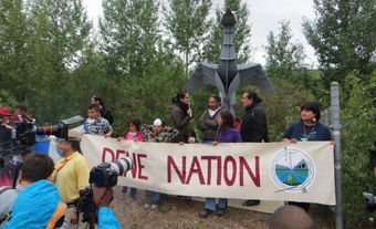
In 1969, the Dene organized the Indian Brotherhood of the Northwest Territories. In 1973, the group began a court challenge to have their land and resource concerns addressed. Soon afterward, in 1974, the Mackenzie Valley Pipeline Inquiry, led by Justice Thomas Berger, began investigating the possible impacts of the proposed Mackenzie Valley pipeline. Berger recommended a 10-year moratorium on pipeline development until Indigenous claims and concerns were properly addressed. In this climate of political activism and growing public support, the Northwest Territories’ first registered reserve, Hay River Dene 1, was created in 1974 on the eastern shore of the Hay River.
Land Claim and Self Government Agreements
In 1973, growing concerns about Aboriginal rights across Canada led the Canadian government to create a new process to address claims to land and resources. It recognized two categories of claims: comprehensive and specific.
The comprehensive claims process was to be used for cases in which no treaty had been signed (as is the case of most of British Columbia, for example). The Dene Nation and Métis Association of the Northwest Territories filed claims in 1976 and 1977 respectively. The government decided to treat these claims as a single, comprehensive claim, even though treaties had been signed in the Northwest Territories. The reasons for this unique approach are not clear. Perhaps it was a tacit acknowledgement that provisions of Treaties 8 and 11 (including reserves) had not been fulfilled. Although an agreement-in-principle was signed in 1988, a final agreement was never reached due to disagreements among the participants. At that point, some of the Dene groups decided to proceed with their own negotiations. The Gwich’in Comprehensive Land Claim Agreement was signed in 1992, the Sahtu Dene and Métis Comprehensive Land Claim Agreement took effect in 1994, the Tlicho Land Claims and Self-Government Agreement took effect in 2005, and the Déline Final Self-Government Agreement took effect in 2016. Others are still being negotiated. Instead of a reserve system, these more recent agreements stress such ideas as direct ownership of land for the First Nation, in the same legal sense that individuals own land elsewhere in Canada, and unlike traditional reserve lands which are held in trust by the Crown.
Creation of Salt River No. 195: 2008
At the same time that the comprehensive claims process was created, the government also announced a specific claims category for cases in which a treaty was in place but there were disputes about the fulfillment of its provisions. In 1992, the Salt River First Nation, located in the territory covered by Treaty 8, began negotiating the creation of its reserve under the specific claims process. The agreement resulting from these negotiations, the Salt River First Nation Treaty Settlement Agreement, was signed in 2002. Salt River No. 195 was officially registered in 2008. Parcels of land were added to the reserve in 2009 and 2011, and more may be added in the future.
Politics

Before contact with Europeans, all branches of the Dene were organized into family centred bands. Decisions were made locally or at larger seasonal gatherings at fish camps through a system of consensus. Today, at both the local and territorial levels, governance reflects a combination of Indigenous traditions and Canadian legal requirements. For example, the Legislative Assembly of the Northwest Territories, while clearly a model imposed from outside, nonetheless operates on a consensus model without political parties.
Between 1884 and 1988, the system of governance laid out in the Indian Act was mandatory for all reserves. In 1988, the federal government amended the act to give First Nations the option of customizing their electoral process. Both the Hay River and Salt River reserves make use of this option, and therefore have broken, to a certain extent, with the old Indian Act regulations. Each community elects a chief and six councillors.
Economic and Cultural Initiatives

Today, the Kátł’odeeche First Nation remains an active part of efforts to maintain Dene cultural identity. The Dene Cultural Institute (Yamozha Kue Society) at Hay River has been promoting Dene art, history and culture since 1987. Projects include an oral history initiative and educational programs. The Kátł’odeeche also operate one of the NWT’s three wellness centres. Using traditional medicines and spiritual practices, the centre is at the forefront of the struggle to overcome past traumas through culturally appropriate programming.
Salt River First Nation’s Aboriginal Headstart Program programs for pre-school children, while the Salt River Youth and Education Foundation provides financial assistance for post-secondary education. The Salt River First Nation is also starting up a number of economic development projects, including a fast-food franchise and a business and conference centre in Fort Smith.