Share on Facebook
 Share on X
 Share by Email
 Share on Google Classroom
Geography and Geology
Lake Ontario occupies a bedrock depression originally produced by stream erosion and later modified by glaciation. Several glacial lakes of varying elevation occupied the basin before the current level and outlet were established about 11,000 years ago. The present basin has an elliptical plan with an east-west orientation and a complex lake bed reflecting its underlying rock structure and the effects of glaciation. The lakeshore is typically a low bluff of rock or glacial sediment with a narrow beach.
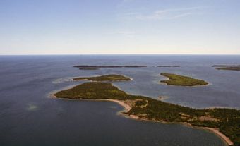
The intersection of older and higher glacial and lake deposits at the southeast end of Toronto has produced the Scarborough Bluffs — spectacular, cathedral-like cliffs rising as high as 100 m above the lake. Other scenic shore features include the rocky coasts and islands of the Kingston Basin and the extensive sandy beaches at Hamilton and Toronto on the Canadian side and Mexico Bay in the US.

Because Lake Ontario is deep and its winter climate is moderated by incursions of warm air from the southwest, its open waters rarely freeze in winter. From November to May the main body is well mixed at uniform temperature. From June through October the lake is stratified, with a warm upper layer 10-20 m thick and a cool lower layer. Temperatures at depths below 100 m are almost always less than 5°C. The average residence time of water in Lake Ontario is 8-10 years, compared with 3 years for Lake Erie and more than 100 years for Lake Superior.
History
The name Ontario is thought to be of Iroquoian origin, meaning “beautiful lake” or “sparkling water.” The first European known to have visited the lake was Étienne Brûlé in 1615. The name “Ontario” was first applied to the lake by Europeans in 1641 and appears on maps of North America as early as 1656. Conflict between the English and French and their Indigenous allies over the local fur trade inhibited European settlement until after the English takeover in 1763.
The first major group of settlers were Loyalists, many of whom settled on the north shore. The most vigorous campaigns of the War of 1812 between the US and Great Britain were fought on or near Lake Ontario. (The vessels Hamilton and Scourge, lost in a squall during a naval engagement at that time, have been found on the lake bed near Niagara.)
Over 55 per cent of Ontario’s population lives near the lake. The “Golden Horseshoe,” which encompasses the western end of the lake and includes the major cities of St. Catharines, Hamilton and Toronto, is the industrial heartland of the country. Urban centres on the lake east of Toronto include Oshawa, Port Hope, Cobourg, Belleville and Kingston.
The other major factors promoting vigorous settlement and growth have been the productive farmland of southern Ontario and northwestern New York state, and access to ocean shipping via the St. Lawrence Seaway and to upper Great Lake ports via the Welland Canal. Smaller craft can travel the Rideau Canal from Kingston to Ottawa and the Trent-Severn Waterway between the Bay of Quinte and Georgian Bay. Unfortunately, industrial and agricultural wealth has also led to the degradation of Lake Ontario water quality by pollution.