Share on Facebook
 Share on X
 Share by Email
 Share on Google Classroom
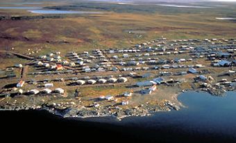
Iqaluit, Nunavut, incorporated as a city in 2001, population 7,429 (2021 census), 7,740 (2016 census). Iqaluit is the capital and largest community in Canada’s newest territory, Nunavut. It is also the territory's only city. Iqaluit is situated at the northeast head of Frobisher Bay, on southern Baffin Island. In an area long used by the Inuit and their ancestors, it is surrounded by hills close to the Sylvia Grinnell River and looks across the bay to the mountains of the Meta Incognita Peninsula.
Settlement
Indigenous Peoples
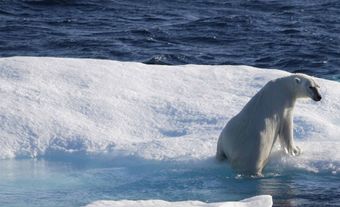
For centuries, Inuit in the area lived in small nomadic groups around the bay, which provided them with caribou, fish, seal, walrus and whales as staple sources of food and clothing. However, their lifestyle was dependent on the movements of the area’s wildlife, which in turn were determined by shifts in local climate. As a result of these shifts, Inuit often travelled extensively in search of supplies.
The first confirmed contact with outsiders was with the English explorer Martin Frobisher, who made three trips to the bay between 1576 and 1578, believing it might be a strait leading to Asia. In 1861, an American, Charles Francis Hall, explored the region further and discovered that it was indeed a bay. In 1914, the Hudson's Bay Company established the first of several trading posts in the area. Despite visits by explorers, traders, missionaries and police, the Inuit still managed to retain a fairly independent lifestyle in their camps.
European Settlement
Change began in 1942 when the United States began building a huge airbase at the head of the bay as part of a planned transportation link to the war in Europe. Inuit took on seasonal work and some began to stay in the area. The airbase, greatly under-used during the war, was later bought back by Ottawa. It sprang to life during the Cold War with the then –Soviet Union when it became the transportation and communications centre for the building of early-warning radar stations (known as the DEW Line) throughout the eastern Arctic.
Development

In 1963, the community (then called Frobisher Bay) began to grow when the federal government made it the headquarters for operations in the Baffin region. By 1971, it had a high-rise complex, new schools and the now famous igloo-shaped Anglican cathedral, initiated by Queen Elizabeth II. In 1987, its residents decided to change the name from Frobisher Bay to Iqaluit, thus reverting to its original Inuktitut name meaning "many fish."
Cityscape

As in more southerly cities, Iqaluit has the full range of services, such as a modern hospital, banks, law courts, schools, day cares and service clubs. The main campus of Nunavut Arctic College is located here. There is also a museum, a visitors' centre, art galleries, several churches, a mosque, satellite communications and an up-to-date computer network. There is a small but vibrant francophone community with its own school and community centre.
Population
The Nunavut Final Agreement between the federal government and Inuit leaders was signed in 1993, setting the direction for the creation of the new territory of Nunavut in 1999. Two years later, Iqaluit was chosen to be the territorial capital. This brought rapid change: construction and employment opportunities boomed, with a corresponding population increase (47 per cent between 1991 and 2001).
According to the 2021 census, 52.1 per cent of Iqaluit’s population is Inuit. The other two most commonly cited ethnic origins are Scottish (12.2 per cent) and Irish (11.6 per cent). Visible minorities account for 12.4 per cent of city residents, with Black, Filipino and South Asian people comprising the largest communities within this group.
Economy and Labour Force
The local economy is still largely government based, but a private sector is developing in areas such as construction, retail, tourism, and arts and crafts. Wages are relatively high compared with southern Canada, but equally so is the cost of living. However, employment levels among Inuit are still disproportionately low, a factor that government and Inuit organizations are working to reduce by offering training courses, preferential hiring and contract work.
Transportation

As the administrative, transportation and communications centre for Nunavut, Iqaluit provides air links with southern Canada, Yellowknife and all Nunavut communities. It has a modern airport with daily flights to and from the South. In summer, despite its high tides, the city also becomes a port, handling the annual sealift of heavy supplies. Rapid growth of the city has seen the advent of more vehicles and the start of southern-style trappings such as street names and public transit.
Communications
The city is also home to CBC North radio and television, delivered in English and Inuktitut, as well as local radio stations and weekly newspapers.
Government and Politics
Iqaluit is Canada’s most northerly capital. Its municipal administration consists of a mayor and eight councillors elected citywide for a four-year term. It provides the usual community services and faces the same municipal issues that confront most other Canadian local administrations. What makes it different is that it serves a diverse mix of citizens who have moved there from others parts of Nunavut and Canada, while trying to preserve a balance between Inuit traditions and more recent changes brought from the South.
By northern standards, the city is a hub of political activity. As the capital, it houses the territorial legislative assembly, all government departments and is the home for many Inuit birthright organizations. For these reasons, it is the linchpin of the three Nunavut regions of Qikiqtaaluk (Baffin), Kivalliq and Kitikmeot. The small satellite community of Apex is five kilometres east of Iqaluit. Nestled around an old-style Hudson's Bay Company store, it came into being in the 1950s as a model village for the Inuit, built by the Canadian government.
Cultural Life
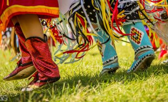
Much of the flavour of Iqaluit lies in its cross-cultural contrasts: Inuktitut, English and French are heard in daily use; men in caribou parkas go hunting while jet planes fly overhead; and sealskins are scraped and cleaned in homes that house a television and perhaps a computer. Carvers can often be seen working outside their homes, and native arts and crafts can be bought in most stores and hotels. Displays of Inuit drama, music, dance, song and fashion juxtapose comfortably with more southern events such as sports competitions. Toonik Tyme, the end-of-winter festival held in April, captures both traditional and modern aspects of the North, from igloo building to snowmobile racing. Because so many Iqaluit residents originate from somewhere else, the community is known for its laid-back, culturally varied and tolerant, welcoming personality.
However, it is still the strength of the land that dominates life in Iqaluit and the Arctic. Although a host of indoor programs, often sport oriented, are offered during the winter, many recreational pastimes — snowmobiling, camping, hunting, boating and hiking — are linked to the great outdoors. Three nearby territorial parks (Qaummaarviit, Katannilik and Sylvia Grinnell) are accessible through local outfitters via boat, snowmobile or dog team, and people from all backgrounds enjoy the easy access to nature and northern flora and fauna.
Iqaluit has become the gateway to the Eastern Arctic both logistically and culturally because it has successfully managed to blend modern facilities and technology with long-time Inuit traditions.