Share on Facebook
 Share on X
 Share by Email
 Share on Google Classroom

The 1883 excavation of a portion of the Bocabec site by the Natural History Society of New Brunswick marked the beginning of systematic, scientific examinations of shell-bearing archaeological sites (see shell middens) in Canada. The initial report on the excavation of this pre-contact site touched on phenomena that remain salient and controversial in prehistoric archaeology today: documenting stratification and cultural change, inferring aboriginal subsistence and settlement patterns, and reconstructing aboriginal domestic architecture and use of space.
The excavation at Bocabec was led and reported by George F. Matthew, of Saint John, New Brunswick, a self-educated natural historian, and officer of the Natural History Society at that time. Despite holding civil service positions at the Customs House in Saint John for much of his working life, Matthew wrote about 200 scientific papers, mostly on Geology and paleontology, but including six papers on archaeological topics. Of the latter, his paper on the Bocabec site, published in the Bulletin of the Natural History Society of New Brunswick in 1884, and reprinted several times since, remains the best known and most influential, both in Canada and the United States.
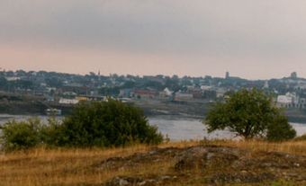
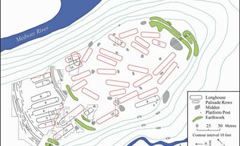
The Bocabec site (sometimes referred to as the Phil's Beach site) is located in a south-facing cove on the eastern side of the estuary of the Bocabec River in the Quoddy Region, part of the traditional territory of the Peskotomuhkatiyik (the Passamaquoddy people). Like all coastal archaeological sites in the region, it was and continues to be threatened by rising sea levels and damaged by coastal erosion. In the early 1880s, the site extended about 50 m along the shoreline and some 40 m perpendicular to the shore. A landward portion of the site had been disturbed by farming and by the construction of "Phil's house," which was already a ruin in 1883. On the shoreward, undisturbed surface of the site, Matthew and his colleagues observed approximately 30 "saucer-shaped depressions," interpreted as the foundations of aboriginal "huts" or dwellings. Excavating and studying these "hut bottoms" became a focus of Matthew's interest.
Domestic Architecture
The dwelling features recognized by Matthew were probably the foundations of pre-contact wigwams, much like those constructed by various Eastern Algonquian groups (see Aboriginal People: Eastern Woodlands) at European contact. The dwellings were oval-floored and about three metres across at their widest. Their inhabitants probably arranged a series of poles to form a frame, over which they fastened sheets of birchbark or hide to make a weather-resistant shelter. Ethnohistoric accounts suggest that many of the materials used to make wigwams could be taken down and moved from site to site and reused.
The inhabitants lined the floors of the structures with clean, rounded gravel from the beach. Over this, they probably placed boughs or furs on which to sleep. Near the centre of the floor, they built a fire for cooking and warmth. Ethnohistoric accounts and archaeological evidence from a coastal site in Nova Scotia suggest that Eastern Algonquians may have arranged space inside such structures according to the gender and ages of the inhabitants, with men and women working and sleeping on opposite sides of the dwellings.
Artifacts and Cultural Change
The artifacts that Matthew and his colleagues recovered included ceramic fragments (portions of pottery vessels tempered with grit or shell and decorated with a variety of distinctive motifs), flaked-stone projectile points (which could be attached to spear or arrow shafts), scrapers for working hides, bark or wood, and ground-stone axes. Because organic tools generally preserve poorly compared to their stone counterparts, it is difficult to infer other portions of the inhabitants' toolkits. However, they likely used bone needles and awls for a variety of tasks (including assembling wigwam coverings).
In light of more recent archaeological research, it is unlikely that, as Matthew suggested, the features at Bocabec represent a "village." Rather, they resulted from a series of occupations by one or a few families at any one time. However, Matthew recognized that the artifacts from the earlier (deeper) layers in the Bocabec site differed in detail from those in the later layers. On this basis, he suggested that the site had been occupied sequentially by two different tribes or races. Although modern archaeologists would not necessarily interpret the differences between the two groups of artifacts in ethnic or racial terms, a study of the artifacts from Bocabec, conducted almost a century after the original excavation, indicated that ancestral Peskotomuhkatiyik inhabited the Bocabec site during both the Middle and Late Maritime Woodland periods, from 2000 to 900 years ago.
Subsistence and Settlement Patterns
Matthew examined the animal remains preserved in the shell middens at Bocabec in some detail. Shell middens at the site, comprised primarily of Mya arenaria (soft shell clam), help archaeologists to reconstruct what the inhabitants at the site were doing, especially what they were eating. Although we do not know the contents of the Phil's Beach shell middens precisely, shell middens at other Quoddy Region sites indicate inhabitants of the sites ate meat from clams, harbour seals, deer, moose, herring, cod, migratory birds, and other animals. The site's occupants probably ate available wild plant foods too, but these are less clear in the archaeological record than are animal remains. Matthew believed he identified charred "grains" from a grass-like plant and charred beach peas (Lathyrus maritimus), but these identifications have not been replicated at coastal sites in the Quoddy Region, so it is unclear whether or not Matthew's plant identifications were correct.
Matthew used this subsistence information to suggest that ancestral Peskotomuhkatiyik resided on marine shorelines in cold seasons as well as in warm seasons. This interpretation presaged several decades of research on pre-contact seasonality and settlement patterns conducted during the latter half of the 20th century that reinforced Matthew's interpretation of the Bocabec site.