Share on Facebook
 Share on X
 Share by Email
 Share on Google Classroom

The Columbia River runs from the southeast corner of British Columbia through Washington and Oregon states to the Pacific Ocean. Its drainage basin is one of the largest in North America, and dams along its Canadian course generate about half of BC’s hydroelectricity.
Course
At 2,000 km in length (801 km of which are in Canada), the Columbia is a long, powerful river. It has cut deep gorges along much of its course, and commands one of the greatest drainage basins in North America, totalling 660,500 km2 (156,000 km2 of which are in Canada).
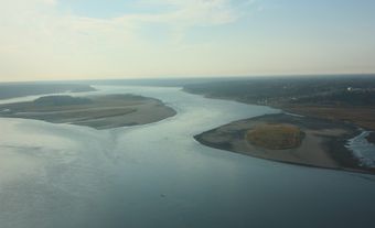
The river begins in Columbia Lake in southeast British Columbia. It then flows north-northwest in a sharp detour around the Selkirk Mountains, through Kinbasket Lake, before abruptly turning south into Lake Revelstoke, from which it then travels through Upper and Lower Arrow lakes to Castlegar, where it is joined by the Kootenay River — one of its largest tributaries. The Columbia River crosses the US border at the confluence with the Pend d'Oreille River.
The Columbia continues south across Washington state, and turns abruptly to the west where it widens into a reservoir behind the large Grand Coulee Dam. It is then joined by the Okanogan River and turns south once more. Just north of the Oregon border, it is joined by the Snake River — its largest tributary — and makes a right-angled turn, flowing west until it opens up to the Pacific Ocean at Astoria, Oregon.
Flora and Fauna

The northeast stretch of the Columbia River runs through the wetlands region of the Rocky Mountain Trench. The wetlands extend from Columbia Lake north to Kinbasket Lake and are flanked by the Rocky Mountains to the east and the Columbia Mountains to the west.This region boasts a high diversity of bird species, including bald eagles, osprey, woodpeckers, great blue herons, and numerous migratory birds such as swans, ducks, Canada geese, grebes, and other shorebirds. This region is also home to painted turtles, river otters, beavers, deer, coyotes, and cougars. The dominant vegetation includes cottonwood, birch, and western larch.Rainbow, bull, and cutthroat trout all swim through this stretch of the river, while Chinook salmon and white sturgeon use it as part of their seasonal migration.
The surrounding mountainous areas of the upper Columbia River are home to wolves, black and grizzly bears, wolverines, mountain goats, bighorn sheep, and moose.Forests at lower elevations are comprised of lodgepole pine, Douglas fir, western hemlock, western red cedar, and white spruce, while higher elevations are dominated by Engelmann spruce, subalpine fir, and lodgepole pine.The dry interior Columbia Basin south of the US border has been developed into an extensive agricultural region, supporting vegetables, tree fruits, and grapes. The lower Columbia flows through the temperate rainforest of the coastal Cascade Mountains.
Environmental Concerns
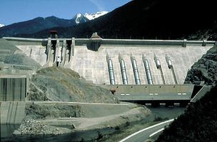
There are 14 dams along the Columbia River, three of which are in Canada (the Mica, Revelstoke, and Keenleyside dams).The Canadian dams produce approximately half of British Columbia’s total hydroelectricity.
The creation of dams often leads to the development of reservoirs, and the Columbia River is no exception. For example, Kinbasket Lake is an artificial lake created by the Mica dam, while Revelstoke Lake was created by the Revelstoke dam.
Reservoirs control the flow of water through dams so that there is always enough water to produce hydroelectricity. During the summer, reservoirs are filled to meet high electrical demand, while in the winter they are reduced. These seasonal fluctuations can impact habitats for migratory birds, while changes to the river’s height can affect the spawning and migration of fish species. Finally, the dams themselves act as barriers to migrating fish, including salmon and sturgeon.
In addition to dams, the Columbia River Basin has been disturbed by mining, industry, forestry and agriculture. Urbanization and other land use changes are a concern, particularly in the US.These land use changes can affect runoff and snow accumulation as well as introduce contaminants, such as pesticides and heavy metals, into the aquatic environment.Numerous roads and highways, including the historic Rogers Pass,traverse the basin and are a source of wildlife habitat fragmentation.Finally, climate change is expected to impact the Columbia River through loss of mountain snowpack, glacier recession,and warmer water affecting fish species.
History
First Nations have inhabited the Columbia River Basin for approximately 10,000 years, since the end of the last ice age.Prior to European contact, these residents were primarily semi-nomadic, using the river for transportation, and sustaining themselves with fish, terrestrial mammals, roots, berries, and other wild vegetables native to the region. Originally called “Rio de San Roque” by Spanish explorers, in 1792 the river was renamed “Columbia” by Boston fur trader Robert Gray, who named it after his ship. At the time, the region had over 100,000 Indigenous inhabitants.
The headwaters of the Columbia River belong to the traditional territory of the Ktunaxa people; the region surrounding Kinbasket Lake and Revelstoke is the traditional territory of the Secwepemc; and the area between Revelstoke and the interior Columbia Basin is the traditional territory of the Sinixt people. European fur trader David Thompson arrived in 1807, set up a fur trade post (Kootenae House), and explored the upper Columbia region.In 1811, he became the first European to travel the entire length of the Columbia River.The local Ktunaxa people provided essential support to the establishment of the fur trade and exploration of the surrounding region.
European settlement of the upper Columbia was driven by mining, forestry, and agriculture, and was facilitated by the Canadian Pacific Railway, which was completed in 1885.