Share on Facebook
 Share on X
 Share by Email
 Share on Google Classroom
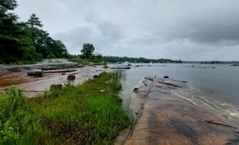
Grand Lake, 534 km2, elevation 85 m, max length 100 km, up to 300 m deep, largest lake on the Island of Newfoundland, is located on the west side of the Island, 24 km southeast of CORNER BROOK.
Grand Lake, 534 km2, elevation 85 m, max length 100 km, up to 300 m deep, largest lake on the Island of Newfoundland, is located on the west side of the Island, 24 km southeast of CORNER BROOK. Fed by numerous small streams and brooks, it drains into Deer Lake via the 11-km Newfoundland Canal, and then via the HUMBER RIVER and Humber Arm, into the Bay of Islands. The canal is part of the Deer Lake hydroelectric project, built in the 1920s to provide power for a pulp and paper mill at Corner Brook. Part of the project is a dam that controls the level of Grand Lake. The lake contains the uninhabited Glover Island (178 km2). Together with its feeder lakes, Sandy and Birchy, Grand Lake forms a waterway much used by canoeists.