Share on Facebook
 Share on X
 Share by Email
 Share on Google Classroom
At 1,470 km2, Gwaii Haanas National Park Reserve, National Marine Conservation Area Reserve, and Haida Heritage Site (also known as Gwaii Haanas) encompasses 15 per cent of Haida Gwaii — a group of islands off the coast of British Columbia, and the ancestral territory of the Haida people. Gwaii Haanas includes over 138 of the approximately 150 islands that make up Haida Gwaii (which were temporarily known as the Queen Charlotte Islands). In the Haida language, Gwaii Haanas means “islands of beauty.”
Overview
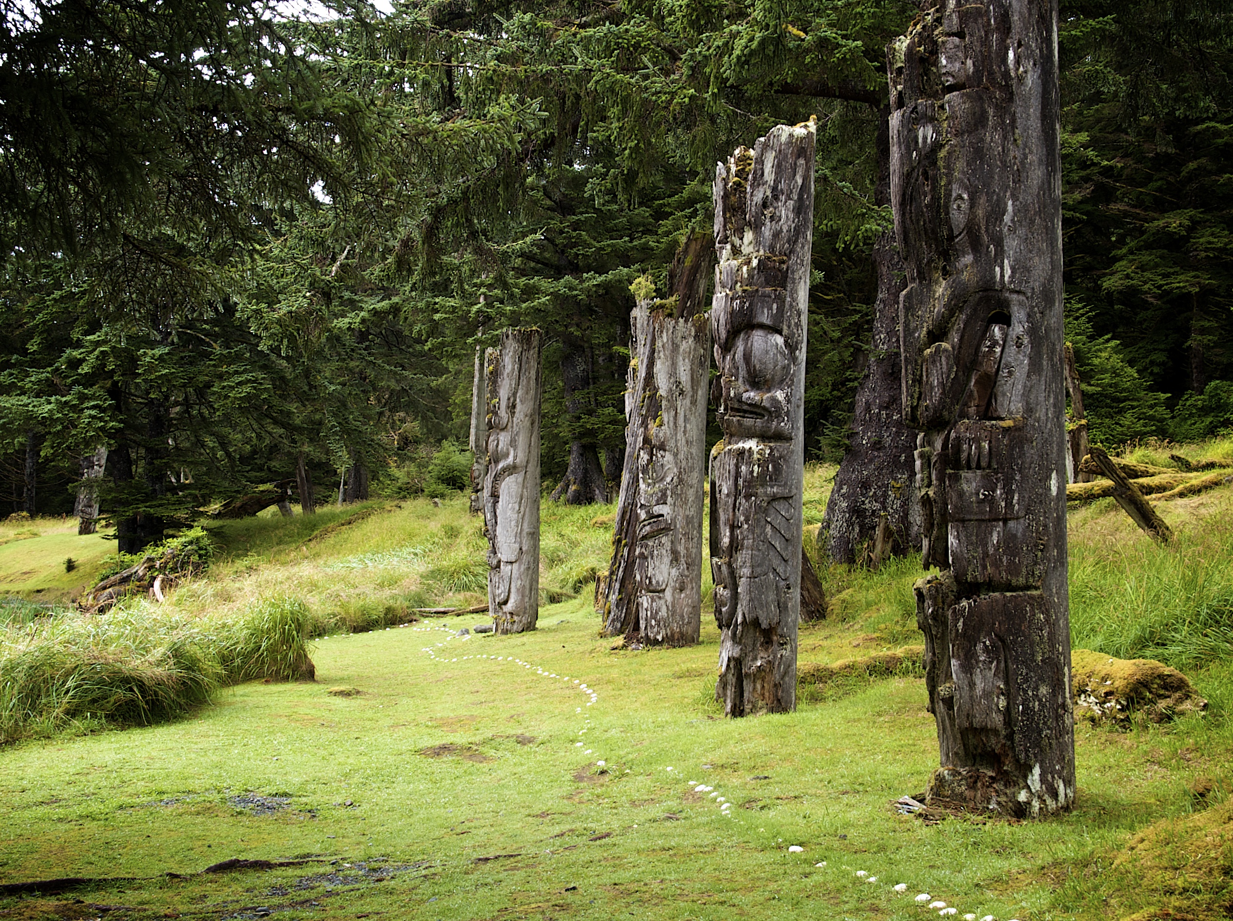

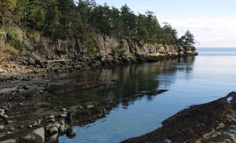
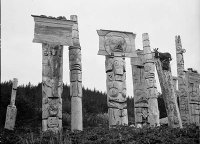
Gwaii Haanas contains 500 identified Haida heritage sites. For example, the village of Nang Sdins Llnagaay (Ninstins) on SGang Gwaay (Anthony Island) is a UNESCO World Heritage Site. Its remaining monumental poles and architecture provide a compelling vision of the living culture passed down by Haida ancestors. As the only place in the world protected from mountaintop to seafloor, Gwaii Haanas supports abundant sea life and temperate rain forests of hemlock, spruce and cedar. Accessible only by boat or aircraft, the area is an attraction for kayakers, boaters, divers, hikers, and scientists of numerous disciplines.
The success of the Haida effort to protect Gwaii Haanas from industrial interests is frequently used to demonstrate how Indigenous people can use civil disobedience to uphold their Indigenous rights and title to the land, giving the islands worldwide historical significance. Together, the Council of the Haida Nation and the Government of Canada maintain a management regime that garners international recognition.
Flora and Fauna

The temperate rainforests, alpine meadows and rocky marine habitats of Gwaii Haanas support a wealth of fungal, plant and animal life.
Aquatic Life

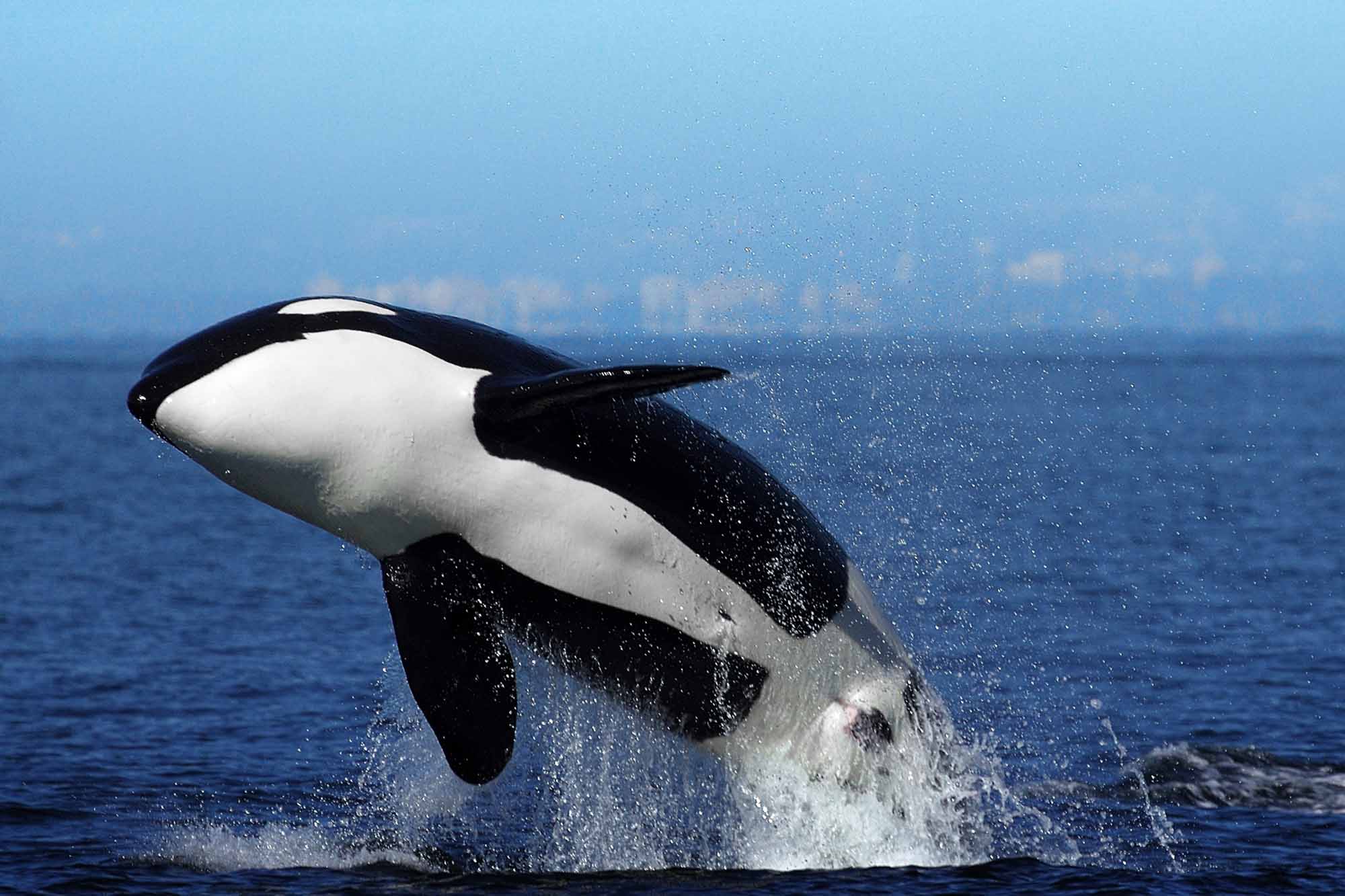
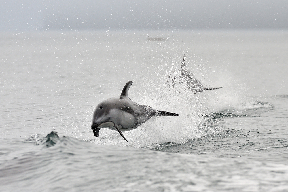
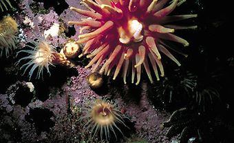
The rich waters surrounding Gwaii Haanas host large Steller sea lion and northern fur seal populations. The seals and sea lions feed on squid and herring. Other marine mammals include elephant seals and 20 cetacean species, such as migrating grey, humpback, sei, fin, minke and blue whales, harbour porpoises, Dall’s porpoises, and Pacific white-sided dolphins. Orca populations hunt in the area as predators on the top of the food chain. While sea otters remain extirpated (i.e., extinct in the area but existing elsewhere), there have been recent sightings of individuals and couples in Gwaii Haanas.
The lakes of Gwaii Haanas contain a number of stickleback subspecies that are specifically adapted to life in the particular lakes where they are found — a phenomenon that has attracted the interest of evolutionary scientists.
In the mid-20th century, the commercial salmon fishery deemed basking sharks pests and claimed they were detrimental to the industry. Between 1955 and 1969 the Coast Guard and the Department of Fisheries and Oceans embarked on an eradication program that contributed to a drastic decline in basking shark numbers along the Pacific coast. Today, they are sometimes seen taking refuge in the protected waters of Gwaii Haanas while their numbers recover
Birds


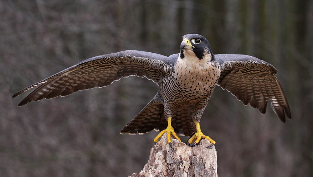
Gwaii Haanas is a significant feeding, breeding, resting and nesting area for well over 200 bird species. From May to August, Gwaii Haanas harbours about 750,000 nesting seabirds, including sandpipers, geese, murrelets, petrels, cormorants, gulls, auklets and puffins, as well as relatively high concentrations of bald eagles and peregrine falcons. While the pine grosbeak, sooty song sparrow, northern saw-whet owl, Queen Charlotte hairy woodpecker and Steller’s jay subspecies are endemic, the ring-necked pheasant, house sparrow, and European starling were introduced. Many burrow-nesters such as the ancient murrelet, rhinoceros auklet, tufted puffin, horned puffin, Cassin's auklet, Leach's storm-petrel and fork-tailed storm-petrel suffer reduced populations due to the introduction of predators like raccoons and rats.
Mammals

Indigenous terrestrial mammals include the dusky shrew and river otter as well as four species of bats: the Keen’s long-eared myotis, little brown myotis, California myotis, and silver-haired bat. Isolation has created at least 39 endemic animal subspecies, including the Haida Gwaii black bear, which is specially adapted to crush shellfish with jaws larger and stronger than those of its mainland relatives. The pine marten, Haida ermine, and Keen’s mouse are also endemic subspecies. Introduced mammals include the house mouse, black rat, Norway rat, red squirrel, raccoon, beaver, muskrat, Sitka black-tailed deer, European red deer and Rocky Mountain elk. The endemic Dawson caribou went extinct between the 1920s and 1930s.
Amphibians
Western toads are the only amphibian native to Gwaii Haanas. They’ve been joined by two species of introduced frogs: the Pacific tree frog and the red-legged frog.
Plants and Fungi

Gwaii Haanas hosts 657 native vascular plants, 34 of which are rare, and 10 of which are endemic. Human activity has introduced 143 additional species, several of which are invasive. The region is also home to over 600 species of fungi.
Natural History
Large numbers of fossils show that much of Gwaii Haanas was once part of a rich marine environment that existed as many as 359 million years ago. Over time, tectonic activity pushed these environments from the seabed to where they stand today, well above sea level. Between 230 and 225 million years ago, violent volcanic upheavals transformed marine lava flows into basalts (dark, fine-grained rock). Since then, subsequent activity has created volcanic and sedimentary formations, including pillow lavas (round, bulging masses of basalt rock). Gwaii Haanas’ geological formation continues today along the west coast, where active faults play a part in ongoing tectonic activity.
For much of the most recent glaciation period (ranging from 100,000 to 10,000 years ago), Haida Gwaii was part of a mountain range connected to mainland North America by a low-lying plain that remained above water because of low sea levels. During this period, much of North America was covered in ice; however, pockets of Haida Gwaii remained unglaciated, allowing fungal, plant and animal species to survive. The presence of coprophilous (dung-loving) fungal spores in excavated fossil layers at Cape Ball indicates that large herding mammals such as mammoths, bison, caribou or mastodons likely populated this plain around 57,000 years ago.
Warming global temperatures deglaciated Gwaii Haanas starting about 14,000 years ago, and rising sea levels covered the plain, creating Hecate Strait. The strait isolated the islands of Haida Gwaii — and the plants, animals and fungi living on them — from what is now mainland British Columbia, leading to the significant number of endemic, disjunct and, in certain cases, abnormally large subspecies that live on the islands today.
Human History
Haida oral records indicate that Haida occupied Gwaii Haanas as early as 14,000 years ago. This oral tradition aligns with the 2014 archaeological discovery of what may be the oldest known settlement site in Canada, found near Gwaay Guusdagang (All Alone Stone), close to the heart of Gwaii Haanas. Estimated to be 13,800 years old, this possible former fishing camp now rests far below the ocean’s surface.
The coasts of Gwaii Haanas are inundated with similar Haida ancestral sites. These old camps, forts and villages demonstrate the amount of geological transformation Haida ancestors lived through. These transformations correspond with Haida stories about floods, glaciers and changing sea levels.
Starting in 1647, European visitors introduced various diseases, causing epidemics in Gwaii Haanas. Most significantly, the smallpox epidemic of 1862 reduced the total Haida population from between 30,000 and 60,000 to fewer than 600 people. This disaster made the people of Gwaii Haanas particularly vulnerable to colonialism and industrialization. As European settlement continued in the 19th and 20th centuries, policies of cultural genocide — including the Indian Act, the potlatch ban, and residential schools — illegalized the Haida language, belief system, and freedoms of expression and movement.
By the 1960s, logging activities in Gwaii Haanas had destroyed many salmon rivers, intertidal areas, harvesting areas and archaeological sites. Unrestricted clear-cutting caused landslides and destroyed salmon-bearing streams and rivers. These environmental changes were exacerbated by the British Columbia Game Commission’s introduction of invasive species such as beavers and deer.
After the surviving Haida had moved away from ancestral sites in Gwaii Haanas, visitors vandalized and damaged the ancestral monuments that remained at Haida villages. The faces of Haida ancestors were torn from monumental poles with chainsaws, and others were cut down and carried away as private trophies. Haida citizens responded by volunteering to watch over Haida villages throughout Gwaii Haanas. In 1981, the Council of the Haida Nation (the Haida national government) and the Skidegate Band Council officially established the Haida Gwaii Watchmen program to monitor access to Haida villages, including K’uuna Llnagaay (Skedans), T’aanuu Llnagaay (Tanu), Hlk’yah GawGa (Windy Bay), Gandll K’in Gwaay.yaay (Hotspring Island), and SGang Gwaay Llnagaay (Anthony Island).
Having witnessed the destruction caused by clear-cut logging in Gwaii Haanas, Haida were alarmed when, in 1975, a company called Rayonier began logging Tllga kun Gwaay.yaay (Lyell Island) contrary to previous government promises. The work continued in 1985 under Western Forest Products — a company in which the majority of British Columbia’s provincial Cabinet, including Premier Bill Bennett, held shares.
In response, in October 1985, Haida citizens set up camp in Hlk’yah GawG a (Windy Bay) and blocked access to the logging road. As a way of officially supporting their resistance, the Council of the Haida Nation also designated Gwaii Haanas land and marine areas as a Haida Heritage Site. Canada responded by posting 25 RCMP officers nearby at Frank Beban’s logging camp.
On 16 November, RCMP officers enforced an injunction, arresting 17 Haida elders. Arrests continued throughout November as Haida continued to protest logging activity. Of the 72 Haida arrested during that time, 11 were convicted of contempt of court in 1986. That same year, Minister of Environment Tom McMillan made an announcement at a celebration feast for the paddlers who brought Loo Taas, the canoe carved by Iihljuwaas (Bill Reid), home from Expo 86. In his speech, the Minister promised that the federal and provincial governments would designate 1,470 km 2 of the southern islands of Haida Gwaii as a national park reserve, with the island of Gwaii Haanas accounting for the largest portion of the area.
Over the next 15 years, the Council of the Haida Nation, Canada, and the Province of British Columbia signed the following agreements: the 1988 South Moresby Agreement, to designate Gwaii Haanas as a national park reserve pending the settlement of Aboriginal rights and title; the 1993 Gwaii Haanas Agreement, to set out the government-to-government and management relationship for Gwaii Haanas; the 2009 Kunst’aa Guu–Kunst’aayah Reconciliation Protocol, to reconcile Haida and Crown titles; and the 2010 Gwaii Haanas Marine Agreement, to conserve the marine ecosystem. This series of protocols and management agreements formally established the Gwaii Haanas National Park Reserve, National Marine Conservation Area Reserve, and Haida Heritage Site, protecting it “from mountaintop to seafloor.”
In August 2013, the Haida Nation and Canada together raised the Legacy Pole and feasted to honour the Gwaii Haanas Agreement’s 20th anniversary. It was the first monumental pole to be raised in Gwaii Haanas in over 130 years. At 13 metres high, it overlooks Hlk’yah GawGa (Windy Bay), the place where Haida protesters originally gathered in 1985 to halt logging — a crucial step toward establishing the conservation and Haida heritage area.