Share on Facebook
 Share on X
 Share by Email
 Share on Google Classroom
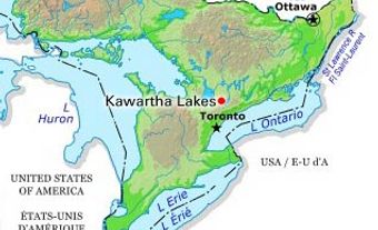
The Kawartha Lakes are a chain of interconnected lakes in south-central Ontario, forming the Trent River's upper watershed. These lakes range in size from 2 to 83 km2. Most of the lakes are located in the city of Kawartha Lakes and Peterborough County.

Hydrology
Some of the lakes considered to be a part of the Kawartha Lakes are Katchewanooka Lake, Clear Lake, Stony Lake, Lovesick Lake, Lower Buckhorn Lake, Buckhorn Lake, Chemong Lake, Pigeon Lake, Sturgeon Lake, Cameron Lake, Scugog Lake and Balsam lake. Hydrologically, Rice Lake (100 km2) should also be included. The lakes drain southeast through the Otonabee and Trent Rivers to Lake Ontario. On the west, Balsam Lake (the highest in the chain) also drains into Lake Simcoe through a canal linking it to the Talbot River.
Name
The name “Kawartha” is an anglicized version of the Anishinaabe word “Kawaategamiing," meaning "land of shining waters (or reflections)." This name was coined in 1895 by Martha Whetung of Curve Lake First Nation.
History
On the northeastern tip of Stony Lake is Petroglyphs Provincial Park, which protects one of North America's largest concentrations of Indigenous rock carvings.
European settlers arrived in the area early in the 19th century. Once the centre of a thriving logging industry, the island-studded lakes became a popular vacation area after 1890, especially for sport fishermen. Steamboats carried visitors to several palatial resort hotels.
Present day
Today, cottages line the shores and pleasure craft crowd the waters. The lakes became larger in volume and area because of the dams and locks for the Trent Canal (now the Trent-Severn Waterway) completed in 1920. The lakes form part of the waterway (administered by Parks Canada), linking Lake Ontario and Georgian Bay. Locks allow pleasure boats to connect with all the lakes in the Kawarthas. Major communities include Lindsay, Fenelon Falls, Bobcaygeon (all now part of the city of Kawartha Lakes), Lakefield and Peterborough.