Share on Facebook
 Share on X
 Share by Email
 Share on Google Classroom
Mistassini, Lac
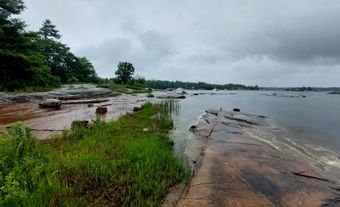
Lac Mistassini, 2335 km2, elevation 372 m, max length 161 km and width 19 km, is located in central Québec, 360 km east of JAMES BAY and 220 km northwest of Lac SAINT-JEAN. Fed by numerous small lakes and streams, it drains to the west, via Lacs Mesgouez and Némiscau, following the course of the Rivière de RUPERT. It is the largest natural lake in the province.
A series of rocky island ridges virtually divide it into 2 separate lakes. It is surrounded by black and white spruce, white birch, poplar, larch, jackpine and balsam fir, which support a fairly extensive logging industry.
The waters of the lake (180 m deep) contain whitefish, pike, gray and lake trout, and freshwater seals have been reported. The caribou have been overhunted, but moose are still frequently seen. The area has also been overtrapped, and the populations of fox, otter, lynx, marten, mink and beaver have been seriously reduced.
The lake was discovered by Abbé Charles ALBANEL in 1672, and was long a centre of the FUR TRADE. It still has a trading post, a Church of England mission and a Cree reservation. Geologist Albert Peter LOW wintered at the lake in 1884-85 and surveyed it June-July 1885. Today the area is famous for its production of blueberries, contributing greatly to the annual Canadian harvest. The name derives from the Cree word mista-assini, meaning "large stone," referring to an erratic boulder of 3 m high located at its outlet.