Share on Facebook
 Share on X
 Share by Email
 Share on Google Classroom
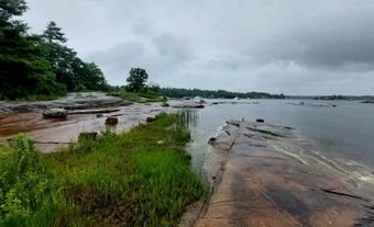
Lac Seul, 1658 km2, elev 357 m, 55 m deep, located in northwestern Ontario, 50 km N of Dryden, drains W via the English and Winnipeg rivers to Lk Winnipeg. It appears as "Lake Alone" - a literal translation of its present French name - on Peter Pond's map of 1784. The Cree, who inhabited the area until the mid-18th century, were gradually displaced by the Ojibwa. Descendants of the latter now occupy the Lac Seul Reserve adjacent to the towns of Hudson and Sioux Lookout. Although the lake was off the main fur-trade routes, both the HBC and NWC were active in the area, and the former continues to be represented at Lac Seul Post. The lake supports a small commercial fishery, but present resource development is concentrated in the forest industry. The unspoiled environment, with its abundant fish and wildlife, also makes this one of the prime outdoor recreation areas in northwestern Ontario. The natural capacity of Lac Seul is augmented by the diversion of water from the Albany River watershed, allowing hydroelectric stations at Ear Falls, where the English R leaves the lake, and Manitou Falls, 30 km downstream, to generate 90 600 kW of electricity.
-
- MLA 8TH EDITION
- Kemp, David D.. "Lac Seul". The Canadian Encyclopedia, 16 December 2013, Historica Canada. www.thecanadianencyclopedia.ca/en/article/lac-seul. Accessed 26 July 2024.
- Copy
-
- APA 6TH EDITION
- Kemp, D. (2013). Lac Seul. In The Canadian Encyclopedia. Retrieved from https://www.thecanadianencyclopedia.ca/en/article/lac-seul
- Copy
-
- CHICAGO 17TH EDITION
- Kemp, David D.. "Lac Seul." The Canadian Encyclopedia. Historica Canada. Article published February 07, 2006; Last Edited December 16, 2013.
- Copy
-
- TURABIAN 8TH EDITION
- The Canadian Encyclopedia, s.v. "Lac Seul," by David D. Kemp, Accessed July 26, 2024, https://www.thecanadianencyclopedia.ca/en/article/lac-seul
- Copy
Thank you for your submission
Our team will be reviewing your submission
and get back to you with any further questions.
Thanks for contributing to The Canadian Encyclopedia.
CloseArticle
Lac Seul
Article by David D. Kemp
Published Online February 7, 2006
Last Edited December 16, 2013
Lac Seul, 1658 km2, elev 357 m, 55 m deep, located in northwestern Ontario, 50 km N of Dryden, drains W via the English and Winnipeg rivers to Lk Winnipeg.