Share on Facebook
 Share on X
 Share by Email
 Share on Google Classroom
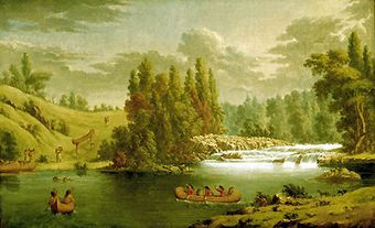
Portage La Loche (Methye Portage), in present-day northern Saskatchewan, was the longest portage (20 km) in the regular fur trade, traversing the height of land between the Hudson Bay watershed and the Arctic watershed.
Geography
Portage La Loche lies between Lac La Loche (the top of the Churchill River system) on the southeast and the Clearwater River (which flows into the Athabasca River) on the northwest. Methy(e) is Cree for burbot (see Cod); after long use, this name was gradually supplanted by the French term for the same fish, loche (or lotte).
History
Peter Pond explored this traditional Indigenous route in 1778, and soon Nor'Westers were portaging canoes and outfits into the rich Athabasca area (see North West Company).
The system was later reorganized by the Hudson's Bay Company : in 1823 the Athabasca brigade left its York boats at the northwest end of the portage, carried the fur packs across and embarked in other boats which were waiting for them at the southeast end.In 1826 the more distant Mackenzie River brigade simply exchanged furs for supplies with the La Loche brigade coming from the southeast.
In the early years local Indigenous people were hired to help portage the heavy loads. By the 1850s, packhorses and oxcarts had come into use, and over 100 tonnes could be portaged annually. After 1886, this route was displaced by the Athabasca Landing Trail, which had been developing since 1875.