Share on Facebook
 Share on X
 Share by Email
 Share on Google Classroom
Humans have been exploring the North American Arctic for centuries, beginning about 5,000 years ago when Palaeo-Inuit were looking for a homeland, followed by the early Inuit (Thule) — ancestors of the Inuit. European exploration of the same region began with the Norse in the 10th century and, after a short pause, was continued by Englishmen during the Elizabethan era (1558–1603). Over the next several hundred years, explorers ventured to the Arctic in search of resources, scientific knowledge, national prestige, personal fame and a navigable Northwest Passage. The most successful of these explorers adapted to the harsh Arctic environment and adopted the tools and practices of northern Indigenous peoples.

Palaeo-Inuit and Early Inuit (Thule)
The coasts and islands of Canada’s Arctic were first explored starting about 5,000 years ago by groups of Sivullirmiut (also known as Palaeo-Inuit). While archaeologists dispute their origins, the Palaeo-Inuit likely set out from Siberia, venturing across the Bering Strait in boats or on the sea ice. They then travelled eastward in small groups, adapting their hunting techniques and tool technology to the environment as they moved across the land and ice of the Arctic Archipelago (see Pre-Dorset). As the Palaeo-Inuit way of life transitioned into the Dorset culture, this process of movement and exploration continued. About 1,000 years ago, another group of people known as the early Inuit, the ancestors of the Inuit, also moved into Arctic Canada from coastal Alaska, exploring and settling in the region.
Early European Efforts: Late 900s–Early 1600s
Following their arrival in the Arctic Archipelago, groups of early Inuit came into contact with the Norse, the first Europeans to explore parts of Arctic North America. After settling along the southwestern coast of Greenland at the end of the 10th century, groups of Norse ventured to the eastern fringe of Canada’s Arctic in search of new land and trading partners.
Arctic exploration renewed in the Elizabethan era (1558–1603) when English seamen sought a shortcut to the Far East by the seas north of America — the so-called Northwest Passage. Martin Frobisher sought the passage in 1576, only to find his way blocked by Baffin Island. After discovering marcasite on the island that he mistook for gold, Frobisher delayed his search for the passage and made two more voyages to Baffin (1577 and 1578) to collect tonnes of useless rock. John Davis sought the Northwest Passage in 1585, 1586 and 1587, exploring Davis Strait and Cumberland Gulf (now Sound), and locating the entrance to Hudson Strait. Convinced that the Northwest Passage rested in this direction, Henry Hudson entered Hudson Bay in 1610, only to be cast adrift after a mutiny.
In 1616, one of these mutineers, Robert Bylot, joined with William Baffin to explore Baffin Bay, sighting the westward-leading channels of Jones and Lancaster sounds. Owing to ice-covered seas and mirage, they mistakenly judged them to be closed bays, a common error among Arctic explorers. The Arctic coast of North America remained unexplored for the next two centuries as explorers looked for an inland Northwest Passage in more southerly regions.
With a great deal of assistance from Indigenous peoples and their technologies, Samuel Hearne made it to the Arctic coast by way of the Coppermine River in 1771, and Alexander Mackenzie did the same using the Mackenzie River in 1789. However, they learned little of the adjoining coasts. By the turn of the 19th century, of the vast Arctic Archipelago, only isolated stretches of Baffin Island’s east shore had been thoroughly explored by Europeans.
The Royal Navy and the Northwest Passage: Early 1800s
In search of a mission after the end of the Napoleonic Wars in 1815, the British Admiralty renewed its search for the Northwest Passage. The decision was motivated more by a desire for national prestige and knowledge than any belief that the navy might actually discover a viable commercial route in the Arctic Archipelago.
In 1818, John Ross rounded Baffin Bay but, like William Baffin, believed that Lancaster Sound was just a bay. In 1819–20 William Edward Parry proved the sound to be the gateway to unknown western seas. Hampered by ice, he sailed along Parry Channel (Lancaster Sound, Barrow Strait and Viscount Melville Sound) to Melville Island, where he overwintered. Across the ice-choked M’Clure Strait he obtained a distant view of Banks Island. On a later voyage, he entered Prince Regent Inlet, where he lost a ship in the ice. Between 1829 and 1833, James Ross joined his uncle John in an expedition that became locked in the ice near the eastern tip of Boothia Peninsula. Learning much from Inuit visitors to their camp, James Ross sledged to King William Island and became the first European to reach the north magnetic pole, a major scientific accomplishment. These early voyages highlighted the brevity of the Arctic summer and showed that even in good ice conditions a sailing ship could stay at sea for barely two months before being immobilized by ice.
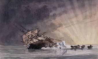
To the south, between 1819 and 1839, canoe and boat parties under John Franklin and later Thomas Simpson explored a channel along the continental shore from the Beaufort Sea to Boothia Isthmus. In 1845, Franklin sailed from England to link this channel with Parry Channel, intending to complete the Northwest Passage. His two ships never returned and went unreported for two years. Britain and the United States sent numerous rescue parties between 1847 and 1859. Because ships were icebound for most of the year, the search for the missing crews could not be done thoroughly. Small parties looked for evidence by hauling equipment and supplies on sledges. Although unsuccessful in their assigned task, these parties mapped much of the Canadian archipelago.
John Rae and Richard Collinson explored and mapped the island coasts nearest the continental shore, while four crews of Captain Horatio Austin’s squadron (1850–51) did the same on both sides of Parry Channel. Sir Edward Belcher explored (1852–54) the area around Exmouth Island and North Cornwall Island and navigated a channel (later named for him) leading to Jones Sound. The great sledge traveller Leopold McClintock discovered and explored parts of Prince Patrick and Eglinton islands in a sledge journey of over 2,100 km.
Robert McClure Discovers the Northwest Passage: 1850–51
Irish explorer Robert McClure is often credited as being the first explorer to discover the Northwest Passage. With the intention of finding John Franklin's lost expedition, the rescue ship Investigator, captained by McClure, sailed from Plymouth, England, on 20 January 1850. It rounded South America and entered the Arctic Ocean by way of Bering Strait. As part of the voyage, McClure discovered Prince of Wales Strait and travelled through it to the northeast angle of Banks Island — thus discovering a Northwest Passage. He had, by an alternate route, accomplished what Franklin had died attempting: he had connected William Edward Parry's voyage from the east with Franklin’s coastal survey from the west. However, like Parry, McClure ran into heavy ice. In September 1851, he found refuge in the Bay of Mercy on Banks Island's north shore, where the Investigator was frozen for 18 months. Its crew was near death when a detachment of Edward Belcher's squadron under Captain Henry Kellett saved them.
Ongoing Search for Franklin: 1851–59
Following Robert McClure's efforts, the search for John Franklin and his men continued. John Rae (1851) and Richard Collinson (1853) were nearly successful but turned back without locating the wrecked ships. In 1854, Rae learned from Inuit that years previous many Europeans had died on western King William Island and on the adjacent mainland. In 1859, Leopold McClintock reached the island by ship and sledge and figured out that Franklin’s vessels had been frozen in that region. The crews had perished of hunger and scurvy while trying to get to the mainland.
Navigating the Northwest Passage: 1903–06
The Northwest Passage had been traced but its navigation was long deferred, as no sailing ship could hope to get through, nor could a steamer stow enough coal to wrestle its way through the ice pack that was certain to be encountered. From 1903 to 1906, however, the Norwegian explorer Roald Amundsen made use of the internal combustion engine to propel his 47-ton Gjøa from ocean to ocean. While Robert McClure had discovered the route by ship and sledge, Amundsen was the first to complete the passage in one trip by boat. Between 1940 and 1942, Sergeant Henry Larsen of the RCMP travelled west to east along the passage and completed a return journey in 1944.
Far North: Late 1800s–Early 1900s
Discovery farther north was largely the work of Americans and Scandinavians. Englishman E.A. Inglefield and Americans E.K. Kane, I. Hayes and C.F. Hall navigated the channel between Greenland and Ellesmere Island, and the survey of Ellesmere’s east shore was completed by the 1875–76 British polar expedition under G.S. Nares. In 1876, P. Aldrich rounded the top of Ellesmere and named the northernmost point of what is now Canadian territory Cape Columbia. Norwegian Otto Sverdrup explored the western shore of Ellesmere Island (1898–1902). Sverdrup and his men also surveyed the entire coast of Axel Heiberg Island, and to the west discovered and mapped Amund Ringnes and Ellef Ringnes islands and King Christian Island.
Between 1913 and 1918, the northern party of the Canadian Arctic Expedition (CAE) led by Vilhjalmur Stefansson outlined the edge of Canada’s continental shelf and discovered some of the world’s last major land masses — Lougheed, Borden, Mackenzie King, Meighen and Brock islands — while drifting dangerously, but deliberately, on ice floes. Stefansson owed much of this success to Inuit and Inupiat members of the expedition who taught him how to travel effectively, dress properly for the weather and live off the land. Despite the successes of the northern party, the venture was fraught with internal dissension, which was amplified by the sinking of the CAE’s flagship, Karluk, resulting in the deaths of 11 expedition members, and by the deaths of six more individuals over the course of the rest of the venture.
In the 1910s and 1920s, several American expeditions continued to voyage into the region above Ellesmere Island in the belief that more land waited to be found around the North Pole. Eventually, aerial flights over the region proved this belief false. The airplane changed the nature of polar exploration and allowed for the aerial mapping of the archipelago. In 1948, an Avro Lancaster of the Royal Canadian Air Force surveying the southern coast of Baffin Island spotted the last large islands to be added to the map of the Canadian Arctic Archipelago — Prince Charles Island, Foley Island and Air Force Island.