Share on Facebook
 Share on X
 Share by Email
 Share on Google Classroom
An earthquake is a vibratory motion generated from the movement of rock along a fault line beneath the Earth’s surface. More than 4,000 earthquakes occur in Canada every year, though the majority of these are not felt. The principal regions for seismic activity in Canada are: the coast of British Columbia; the Cordillera region; the Arctic; and to a lesser extent, the eastern provinces and the eastern seaboard.
Description
The below-ground rupture that starts an earthquake produces seismic waves that spread outward from its initiation point or focus. At the surface, the region immediately above the focus — called the epicentre — experiences the strongest shaking. At greater distances, the seismic ground motion is detectable only by sensitive instruments (e.g., seismographs).
The depth of an earthquake’s initiation point varies from near surface to 700 km. Most continental earthquakes occur in the crust at depths of less than 40 km. Deep-focus earthquakes (below 300 km) are restricted to parts of very active seismic belts.
Scale
There are many measures of an earthquake's size, the best known being that devised by Charles Richter in 1935. Recognizing the need to quantify earthquake size, Richter created a scale (calibrated against seismograph records) that takes into account the reduction of seismic waves with distance from the earthquake focus.
On the Richter magnitude scale (M), earthquakes below M2 are generally not felt, even when occurring at shallow depth. Shallow M5 events cause damage only when the epicentral region supports structures built on loose soils or unconsolidated sediments. M6 earthquakes in populated areas frequently cause considerable damage. The great earthquakes of this century have had magnitudes of about 8.5. Approximately 100 of the world’s earthquakes each year are M6 or greater; fortunately, most occur offshore or in unpopulated areas.
The severity of surface ground shaking at a particular distance from the source is described by its intensity at that location. The Modified Mercalli Intensity Scale, used in North America to quantify the degree of surface effects, ranges from MMI (barely perceptible ground motion) to MMXII (total destruction). MMVI is the threshold of damage.
Canadian Seismic Zones
In Canada, earthquakes occur along the West Coast, in the Cordillera, High Arctic, Eastern Canada and along the eastern seaboard. Elsewhere in Canada, earthquakes are rare and of small magnitude.
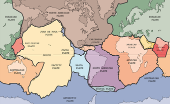
In the Cordillera, moderate earthquakes occur in the crust. Along the West Coast, and beneath Vancouver Island and the Strait of Georgia, earthquakes are the product of active plate subduction (i.e., the sliding of the ocean’s crust under a continent). (See Plate Tectonics; Geological Regions; Geological History). The small Juan de Fuca plate is currently being thrust beneath the Olympic Mountains and southern Vancouver Island. The result is a zone of earthquakes beneath Puget Sound in Washington, U.S. These earthquakes occur at depths of 70–100 km, overlain by a zone of shallower, generally smaller events. The regime extends north to Canadian territory and the southern Strait of Georgia.
Earthquakes in this region also occur as a result of slipping between the Juan de Fuca Plate and the North American plate, which are pressed together. Sudden movement between the two plates can create powerful earthquakes.
There are also active seismic zones in the Richardson and Mackenzie mountains in the Yukon and a relatively limited seismic zone in the Beaufort Sea. Numerous earthquake zones occur in the Arctic islands, one extending south through the Boothia Peninsula, across the mouth of Hudson Bay and northern Québec to the Labrador Sea.
In eastern Canada there is seismic activity throughout the northern Appalachians, the series of M5 events in the Miramichi region of New Brunswick in 1982 being an example. More concentrated zones occur at the mouth of the St Lawrence, in the St Lawrence Valley near La Malbaie in Charlevoix County and in western Québec. The Charlevoix zone is the site of most of the larger events in eastern Canada.
Monitoring
Earthquakes in Canada are monitored by the National Seismograph Network operated by the Geological Survey, Natural Resources Canada. Approximately 100 seismographs are distributed from St John's to Vancouver Island and from Alert in the High Arctic to the Niagara Peninsula. The network is capable of detecting all earthquakes greater than M3.5 anywhere in Canada and those greater than M2 in more densely populated regions. Approximately 300 events greater than M3 are located annually. Probability estimates of seismic ground motion resulting from Canadian earthquakes are incorporated into the National Building Code of Canada; structures designed according to its provisions can resist moderate earthquakes without significant damage and major earthquakes without collapse.
Historic Earthquakes
Of the many earthquakes that occur in Canada each year, some are deemed historic for a number of different reasons, including: their magnitude; the amount of damage they caused; or, in some cases, the number of resulting deaths. With these criteria in mind, the text below details 10 of the worst earthquakes in Canadian history.
The earliest recorded earthquake in Canada took place on 5 February 1663. Occurring in the Charlevoix–Kamouraska region in Québec, at a probable magnitude of 7, the earthquake was felt over much of eastern North America. It also prompted landslides along the St. Maurice, Batiscan and St. Lawrence rivers.
There is now good evidence that a strong earthquake occurred on 26 January 1700 producing a huge tsunami all along the West Coast. First Nations’ oral history describes how the quake — estimated to be a M9 — and tsunami wiped out a village at Pachena Bay, on the west coast of Vancouver Island.
On 4 September 1899, a M8 earthquake struck along the Yukon–Alaska border. Those in northern British Columbia and the southern Yukon felt the quake, as well as several aftershocks in the days that followed.
On 28 February 1925, a M6.2 earthquake was felt throughout eastern Canada and the northeastern U.S. The epicentre for this quake was in Québec’s Charlevoix–Kamouraska region. Homes in communities along the St. Lawrence River were damaged, as were several prominent buildings, including the Gare du Palais (Québec City’s railway station).
Although the Pacific Coast and parts of central and Atlantic Canada have been shaken by earth tremors, the only one (magnitude 7.2) causing extensive loss of life was centered about 250 km south of the Burin Peninsula, Newfoundland, on 18 November 1929. A tsunami struck the area, sweeping away houses, boats and fish stages. Damage was estimated at $1 million; 27 people died.
Baffin Bay was the site of an M7.3 earthquake on 20 November 1933, one of the largest earthquakes ever recorded in the Arctic Circle. Because of its offshore epicentre and remote location, no damage was reported.
Vancouver Island’s largest earthquake, and the largest onshore earthquake in Canada, occurred on 23 June 1946. At a magnitude of 7.3, the quake caused considerable damage, including the toppling of 75 per cent of the chimneys in communities near the epicenter, namely in Cumberland, Union Bay and Courtenay. An earthquake-generated wave capsized a boat, killing one Canadian, while another person died of a heart attack in Seattle.
On 22 August 1949, a M8.1 earthquake occurred off the coast of the Queen Charlotte Islands (now Haida Gwaii), British Columbia, generating a tsunami. On the islands themselves, people were incapable of standing, while on the mainland cars bounced. Chandeliers reportedly shook as far away as Jasper, Alberta.
In the Nahanni region of the Northwest Territories, a M6.9 earthquake on 23 December 1985 caused landslides, rock falls and a rock avalanche. The quake was felt in the western Northwest Territories, southeastern Yukon, and northern Alberta and British Columbia.
Though very little damage was reported, a major earthquake occurred off the coast of Haida Gwaii on 28 October 2012. The M7.7 quake was felt onshore in Prince Rupert, Quesnel and Houston, British Columbia.