Share on Facebook
 Share on X
 Share by Email
 Share on Google Classroom

Origins and Formation
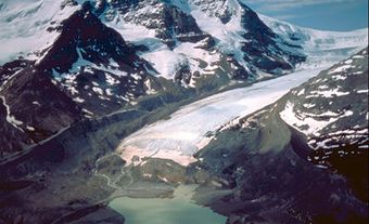
The Trench itself is a large fault (crack in the Earth’s crust) and is bordered along much of its length by smaller faults. Its major structural features are the result of the movement of tectonic plates during the early Cenozoic Era, which began about 65 million years ago. Geologists theorize that shifting plates compressed the crust, causing it to lift and form mountains. A subsequent reversal of this movement caused the ridges of fractured crust to pull apart and the land in between dropped, creating the floor of the Trench. Erosion and deposition by rivers and glaciers have also contributed to its present form.
While the northern half of the Trench is very straight, the southern half is more winding. A number of major rivers, including the Columbia, Fraser and Peace rivers, originate in or flow through the Trench. While seven major rivers once ran through different parts of the Trench, the construction of hydroelectric projects, particularly those at Peace Canyon and Mica Dam, have disrupted their millennia-old paths. Today, all but the Fraser and Kechika rivers empty into reservoirs on the valley floor, such as those at Williston Lake and Revelstoke Lake.
Wildlife and Vegetation
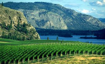
Consisting primarily of forest, the northern part of the Trench is mostly undeveloped and sparsely inhabited by humans. Common tree species in this region are white and black spruce, subalpine fir and lodgepole pine. Animals common in the northern half include wapiti , grizzly and black bears, caribou, moose and wolves. The southern Trench is home to low-elevation, dry, open forests and grasslands. Its larger human population has transformed some areas into farmland and ranges for grazing and hunting .
Human Activity and Impact
(courtesy Native Land Digital / Native-Land.ca)
The Rocky Mountain Trench runs through the traditional territories of a number of First Nations, notably the Ktunaxa (Kootenay), Dakelh (Carrier), Sekani and Kaska Dena. The valley and its surroundings have, for generations, provided these peoples with abundant natural resources, including salmon.
The first European fur traders and trappers came into the region in the late 18th century, employed by the North West Company and assisted by guides from Indigenous communities. Permanent White settlers soon followed, though they did not arrive in significant numbers until the discovery of gold in the Kootenay Valley in 1864, the completion of the Canadian Pacific Railway main line in 1885 and the opening of the Sullivan Mine in Kimberley in 1910. The construction of the Grand Coulee Dam in Washington, which began in 1933, blocked the salmon from reaching the Columbia River. Combined with government policies such as reserves and residential schools, the loss of the salmon had a devastating impact on the ways of life of the First Nations inhabiting the Columbia River basin (see also Indigenous Peoples: Government Policy).
Economic diversification and improvements in the road and highway system over the following decades ushered in a new era of population growth. The Trench has since become a popular destination for both business and leisure. The southern portion of the Rocky Mountain Trench is one of British Columbia’s most important transportation corridors. It is also a tourist and recreation area known for its hiking, fishing and skiing (alpine as well as cross-country). Mining, forestry and agriculture are among its primary industries and sources of employment. Numerous towns and settlements dot the area, the largest being Kimberley and Cranbrook.

Population growth and accompanying development have put significant strain on the environment of the Trench. There are now several organizations dedicated to protecting and restoring the region’s ecosystem through governmental policy recommendations and educational programs designed to raise awareness (see also Environmental Governance).