Share on Facebook
 Share on X
 Share by Email
 Share on Google Classroom
Most maps created in the 1500s that relate to Canada are manuscript compilations, often undated and anonymous. They were prepared by European cartographers rather than by explorers. Since cartographers had to work with available material, these maps are at times a perplexing mixture of new information and old, copied from unspecified sources. Any review of the sequence in which Canada was first mapped is therefore somewhat conjectural. (See also History of Cartography in Canada.)
Vinland Map
Until 1974, a map known as the “Vinland Map,” acquired by Yale University almost a decade earlier and showing the northeast coast of North America, was thought to be the earliest cartographic representation of Canada. It is now generally believed to be a forgery.
Early Maps of Canada and North America

The earliest known maps of Canada date from about 1502 to 1506. They depict the east coast of Newfoundland as that of an island in the North Atlantic. Europeans were not aware of the land between Greenland and the Caribbean. The most significant of these early maps are those known as the “Cantino,” “Canerio,” “King-Hamy”, “Oliveriana” and “Kunstmann II” charts.
Of these, the earliest is probably the Cantino chart (c. 1502). It appears to have originated with the voyages of Gaspar Corte-Real (1500–01). No maps from John Cabot’s 1497 voyage appear to have survived.
Some scholars have interpreted the La Cosa chart, dated 1500, as a confused copy of a Cabot map. Others have pointed out that it contains information available only as late as 1508. In any case, none of the geographical features of the map that some scholars have interpreted as showing the eastern coast of Canada can be identified in such a way as to achieve scholarly consensus.
The first printed maps to show parts of North America, such as the “Contarini” (1506) and “Ruysch” (1507–08) maps, show the east coast of Newfoundland joined to Greenland as an extension of Asia. These configurations were probably based on Corte-Real’s guess that Greenland and Newfoundland were connected, and Cabot’s that they were all part of Asia.
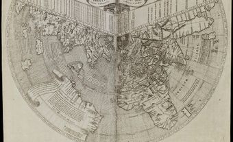
In 1507, a map by German cartographer Martin Waldseemüller was the first to separate North America from Asia, a concept that gained popularity during the next decade.
During the 1520s, the east and south shores of Newfoundland as well as the east shore of Nova Scotia became better known. Maps of this period portray geographical features less ambiguously than those of the previous 20 years. Better maps, such as the “Miller I” (c. 1516–22), the Pedro Reinel (1516–20) and the map attributed to Diogo Ribeiro (the “Weimar” map, 1527), even hint at openings south and north of Newfoundland where later the Cabot Strait and the Strait of Belle Isle were explored by Jacques Cartier.
At least some of the features on these maps appear to be based on the exploration of João Alvares Fagundes (c. 1519–26). The first maps showing the entire coastline from Florida to Newfoundland were based on the explorations of Esteban Gomez (1525) and Giovanni da Verrazzano (1524).
Although Gomez had hinted at an opening where the Bay of Fundy should be, all the maps of this period show an unbroken coastline. Later maps, such as the ones by Santa Cruz (1542), Lopo Homem (1554) and Diogo Homem (1558), drawn from data produced in the 1520s, demonstrate that Gomez actually suspected Nova Scotia to be an island, while some Portuguese more or less knew its true configuration.

After Cartier’s explorations (1534–42), the entire cartography of Canada underwent revision. None of Cartier’s maps has survived. Those believed to be closest to his originals are a chart by John Rotz (1542) depicting the results of Cartier’s first voyage (1534), Pierre Desceliers’ map of 1546 and the “Harleian” world map (c. 1547). The last two depict Cartier’s explorations to 1536. The outstanding contribution of these maps is that they add the Gulf of St. Lawrence and the St. Lawrence River to the shape of North America.
A second group of maps, based apparently on French and Portuguese mapping, depicts the St. Lawrence along with more realistic shapes for Newfoundland and Nova Scotia. The best example of these maps is the “Vallard map” (1547). Few printed maps of this period deserve consideration, but one of significance is the famous 1569 world chart by Gerardus Mercator, which introduced the map projection bearing his name.
Arctic Mapping
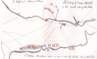
Arctic mapping began with Martin Frobisher’s first voyage (1576), although the southern tip of Greenland had appeared on maps since 1502. Frobisher’s map of the bay named after him on southeastern Baffin Island has survived but, since he did not place his explorations in the context of the rest of North America, cartographers were uncertain where to place it (see also Frobisher Bay).
On the maps of George Best (1578) and Michael Lok (1582), Frobisher Bay appears as a Northwest Passage across North America. Following the less ambiguous maps that emanated from John Davis’s voyages (1585–87), Frobisher’s “strait” was moved to the southern tip of Greenland, where it remained through much of the 17th century. Only a few cartographers made any attempt to link the northern discoveries with those on the St. Lawrence and the East Coast. Probably the best attempt is a world map by Edward Wright, printed in 1599.