Share on Facebook
 Share on X
 Share by Email
 Share on Google Classroom
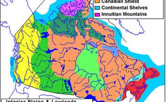
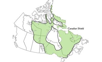
Canada may be divided into seven physiographic regions. The Canadian Shield is the largest and oldest of these regions. The other six physiographic regions are younger and form two concentric rings around the Canadian Shield. The outer, older ring contains the Western Cordillera, Canadian Arctic and Appalachian Region. The second, younger ring contains the Interior Plains, Hudson Bay Lowlands and the St. Lawrence Lowlands. These regions may be further sub-divided based on their structure, relief and the presence or absence of permafrost and forest cover (see Natural Regions).
Areas quoted for these regions are the land areas and do not include adjacent continental shelves or bodies of ocean water within Canada's territorial limits. Readers should also note that the abbreviation “masl” stands for “metres above sea level.”

Canadian Shield
With an area close to 5 million km2, the Canadian Shield covers 48 per cent of Canada's land surface (including freshwater lakes and Arctic islands). Even if the portion of the Shield found in the Arctic is excluded, the Canadian Shield remains the largest physiographic region in Canada. Almost all of Quebec and Ontario, much of Manitoba and northeastern Saskatchewan, and large portions of the Northwest Territories and Nunavut, notably southeastern Ellesmere Island and much of Baffin Island, are underlain by the Canadian Shield. It is a vast, saucer-shaped region. The rim on its south, east and northeast sides is like that of a soup plate and the centre a sedimentary rock basin, the southern fringe of which underlies the Hudson Bay Lowland.
In addition to being the largest physiographic region in Canada, the Canadian Shield is also the oldest. It is composed of crystalline Precambrian rocks formed during several phases of mountain building between 4 billion and 1 billion years ago. In the last billion years it has remained a relatively stable bulwark, unaffected by the plate tectonic movements that have impinged on it to form the mountainous fringe of Canada. The stability of the Shield has allowed denudation to level its surface, giving it its characteristic level or undulating skylines.

The southeastern and eastern borders of the Canadian Shield have been uplifted in the relatively recent geological past. This uplift was the result of tectonic movements associated with the creation of the Atlantic Ocean. Approximately half of the Shield is classified as upland. This upland area extends from northwestern Quebec through northern Ontario, Manitoba, Saskatchewan and southern Nunavut to northwestern mainland Nunavut and the eastern Mackenzie districts in the Northwest Territories. Here, the terrain is 200–500 m in elevation and considered upland only by virtue of its elevation above the Hudson Bay Lowland and the Interior Plains that border it. Bedrock relief of only 50–60 m has been smoothed by a thin mantle of glacial till and sediment deposited in glacial lakes.
Hudson Bay and the Gulf of St. Lawrence dominate the eastern Canadian Shield. Elevations increase from 300 m near the coasts to 900 m in central Labrador and Quebec. Relief of 150–300 m is caused by the incision of valleys into the higher terrain. At several places over the Canadian Shield, uplands and plateaus are broken by belts of hills. The relief of the hills increases because of differential erosion of linear geological structures formed in former mountain belts. Examples are the Labrador and Port Arthur hills.
The high, rugged terrain along the east and southeast rim of the Canadian Shield is classified as highland on Baffin Island and in northern Labrador it stands at 800–1,500 masl. Here, the terrain consists of rolling plateau surfaces that are deeply dissected by glacial troughs, giving a fjord-like aspect to these coasts. Highlands north of the St. Lawrence River stand at 500–900 masl, with isolated summits at 1,000–1,200 masl.
The two extensive Canadian Shield zones, east and west of Hudson Bay, were the centres of ice sheet outflow during the last glaciation (from 75,000 to 6,000 years ago). The central parts of these zones show unorganized terrain mantled with till and also pocked with irregular, shallow lake basins. Around these, glacial scouring of the bedrock is more obvious. Occasional, ice-moulded till hills and many eskers mark the courses of subglacial rivers, and large moraines indicate pauses in the retreat of the ice front across the Canadian Shield. The periphery of these two core areas is marked by more level terrain that was flooded by lakes and seas during ice retreat.
Take the quiz!
Test your knowledge of Canadian geography by taking this quiz, offered by the Citizenship Challenge! A program of Historica Canada, the Citizenship Challenge invites Canadians to test their national knowledge by taking a mock citizenship exam, as well as other themed quizzes.
Western Cordillera
The Western Cordillera is about 800 km wide and extends from southern British Columbia north to the Yukon and the Beaufort Sea. While most of the Western Cordillera lies within these regions it also extends into southwestern Alberta and the Northwest Territories. The total area covered by this physiographic region is 1.6 million km2 (16 per cent of Canada).
The Western Cordillera includes plateaus, valleys and plains as well as rugged mountains. The most continuous mountain chains, known as the Coast and Rocky Mountains, form high rims along the southwestern and southeastern sides of a belt of varied terrain.
There are three distinct mountain systems within the Western Cordillera. The Eastern system consists of sedimentary rocks that have been tilted, faulted and folded. The Interior system's mountain ranges and dissected plateaus are underlain by folded sedimentary and volcanic rock, metamorphic rock and numerous small igneous intrusions. In the Western system, the Coast Mountains consist of a mass of interlocking igneous intrusions and metamorphic rocks. However, the westernmost mountains (the Haida Gwaii and Vancouver Island ranges) are geologically similar to the Interior system.
The oldest recognizable feature of the Western Cordilleran landscape is the gently rolling upland of its interior plateaus. This ancient surface was sculpted by erosion many millions of years ago. Since then, it has been uplifted, partly buried by lava flows, dissected by river erosion and modified by the Cordilleran ice sheet. The most widespread landforms and surface deposits of the Western Cordillera date from the glaciations of the past 2.6 million years. South of 60° N, only the highest mountain peaks projected above the Cordilleran ice sheet as nunataks. Farther north, extensive parts of the Yukon, Nunavut and the Northwest Territories were too dry for glacier formation, although very cold.
In the glaciated areas, landforms such as cirques and U-shaped valleys are common in the mountains and along the edges of higher plateaus. Features such as striations, drumlins, eskers and till plains are widespread on plateaus and plains. Valleys and lowlands commonly contain thick silts and clays that were deposited in ice-dammed lakes during glacier melting, and sands and gravels that were deposited by meltwater streams.
During the 12,000 years of postglacial time, rivers have formed terraces, alluvial fans, floodplains and deltas (see River Landform). Rockfalls, debris flows, landslides, soil creep and snow avalanches have modified the sides of valleys. Periglacial landforms are present above the treeline. In the south, permafrost exists beneath only the highest, windswept ridge crests. Northward, however, the permafrost limit becomes lower and, in the central and northern Yukon, there is permafrost at all elevations.
Volcanic activity has occurred sporadically at scattered locations in the Western and Interior mountain systems up to the present. Some eruptions occurred underneath the Cordilleran ice sheet. The youngest lava flows and cinder cones are only a few hundred years old; these eruptions are described in certain legends told by Indigenous peoples.
The Cordillera encompasses a variety of climates because of its great latitudinal extent, its location between the Pacific Ocean and the continental interior, and its rugged terrain. Several significant effects of climate are visible in the natural landscape. For example, heavy rain and snow on the Coast Mountains give rise to dense forests and maintain extensive snowfields and glaciers at relatively low elevations above sea level. However, over the past two decades, these snowfields have been greatly reduced by climate change.
The altitudinal timberline and the snowline rise eastward as snowfall decreases, and descend northward as temperature declines. Differences in climate caused by elevation in any particular area are reflected by altitudinal vegetation zones. The highest of these is the alpine tundra. In the semiarid valleys of the Interior system, the lowest vegetation zone is grassland. Here again, climate change continues to alter the boundaries of these zones.
Canadian Arctic

Canada's Arctic is located north of the Arctic Circle and comprises 2.1 million km2 (21 per cent of the country’s land area). The Arctic is Canada’s most complex physiographic region, in part because it overlaps with other regions, namely the Canadian Shield, Western Cordillera and Interior Plains. These three regions of overlap may be considered subregions of the Canadian Arctic, in addition to three others: Innuitia, the Arctic Lowlands and the Arctic Coastal Plain. The unifying physiographic characteristic of these six subregions is continuous permafrost and treeless tundra. For information on the parts of the Canadian Arctic that overlap with other physiographic regions, see the sections of this article that pertain to those regions. For information on the subregions and characteristics specific to the Canadian Arctic, see below.
Glaciers
Glaciers are the most distinctive characteristic of the Canadian Arctic. The islands of the Canadian Arctic contain about 130,000 km² of glaciers and ice caps, representing 28 per cent of the world’s glaciers (excluding ice sheets such as Greenland and Antarctica). Most of these are located in the Queen Elizabeth Islands (Ellesmere, Axel Heiberg and Devon islands) and Baffin Island.
The glaciers themselves are frozen to the underlying bedrock and move very slowly. The mountains in which they are located have a unique appearance, being nearly buried by ice caps and glaciers through which the peaks project as rows of nunataks. Those glaciers that are monitored have thinned by 8─12 m since the early 1960s (see Climate Change). Model projections indicate that, under moderate warming scenarios, they will probably lose 20 per cent of their mass by 2100. It is estimated that this loss of glacier mass is equivalent to around 50 mm of sea level rise.
Innuitia
Innuitia is a region of varied topography developed from thick assemblages of deformed sedimentary rocks and minor intrusions. There are four distinct areas within Innuitia, namely the Innuitian Mountains, the Eureka Uplands, the Parry Plateau and the Sverdrup Lowlands.
The high-relief Innuitian Mountains occupy the northwest of Ellesmere Island and central and western parts of Axel Heiberg Island. The local relief is as much as 1,300 m and the highest summits reach 2,600 masl.
The moderate relief Eureka Uplands lie in central and western Ellesmere Island and eastern Axel Heiberg Island. They are rolling and ridged surfaces controlled by underlying folded strata. The elevations of the uplands are generally less than 1,000 masl.
The moderate relief Parry Plateau dominates Bathurst and Melville islands. The low-relief Sverdrup Lowlands are developed on a structural basin of generally soft, poorly consolidated and little-deformed Mesozoic rocks.
The mountains and uplands of Ellesmere, Axel Heiberg and Devon islands provide a strong contrast with the lowlands and plateaus of the southwest of the Innuitian region. The latter is characterized as having the most extreme cold climate in Canada. Patterned ground is ubiquitous. Vegetation is limited to low tundra communities, with barrens in many places reflective of both the short growing season and extreme aridity.
Arctic Lowlands
The Arctic Lowlands are formed on flat-lying or nearly flat sedimentary rocks. Victoria and Banks islands are characterized by a smooth, undulating ancient erosion surface covered by a variety of glacial deposits. Extensive areas of drumlinoid ridges give a characteristic grain to the topography. The Shaler Mountains are composed of stratified rocks intruded by gabbro sills. These form cuestas and are capped by flat-lying volcanic rocks. The highest point of Victoria Island is around 800 masl.
Several distinctive landforms occur in the Canadian Arctic, most often associated with the growth of permafrost and ground ice. Tundra polygons, a tortoise-shell pattern of cracks up to 30 m apart with ice wedges below the cracks, cover many thousands of square kilometres. Other distinctive landforms are pingos, of which 1,350 have been counted near the Mackenzie Delta.
Lakes and rivers used to be ice-free from July through August and ice-covered for the rest of the year. However, over the past two decades, climate change has extended the ice-free period by several weeks.
Arctic Coastal Plain
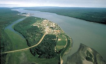
The Arctic Coastal Plain includes the coastal terrain of the Beaufort Sea from Meighen Island in the north to Banks Island in the south and, on the mainland, the Mackenzie Delta and the Yukon coastal plain. On Meighen Island, unconsolidated sands and gravels have been uplifted 200 m and eroded to form hilly terrain. The island also features an ice cap with a summit of 250 masl. The longest river in Canada, the Mackenzie, flows north from Great Slave Lake and empties into the Beaufort Sea at the Mackenzie Delta (see also Longest Rivers in Canada). The Mackenzie Delta includes complex fluvial-marine features like Cape Bathurst.
Appalachian Region
The Appalachian Region is 360,000 km2 or about 3.6 per cent of Canada's land surface. It lies between the St. Lawrence Lowlands to the northwest and the Atlantic Continental Shelf to the east and southeast. Like other mountain regions, its terrain is a mosaic of uplands and lowlands, the characters, boundaries and shapes of which reflect the complexity of its rocks and structures. These were inherited from tectonic movements between 480 and 280 million years ago. Since then, denudation has removed several kilometres of rock, revealing once deeply buried structures.
At the same time, regional uplift has maintained smooth-topped uplands and highlands on stronger rocks, while weaker rocks have been fashioned into lowlands and plains. Highlands and mountains are disposed in a Z-shaped belt, from the Quebec border with Vermont and New Hampshire, northeastward to the Gaspé Peninsula, southwestward across New Brunswick, and then continuing northeast north of the Bay of Fundy to Cape Breton Island. From there, broken by Cabot Strait, the belt continues along the high, western spine of Newfoundland. These highlands reach over 1,200 m in the central Gaspé Peninsula (e.g., Mont Jacques-Cartier, 1,268 masl).
In western Newfoundland and northeastern New Brunswick, summits stand at 600–800 masl. Elsewhere in the region, this highland belt is flanked by uplands at 300–600 masl in Quebec, northwestern New Brunswick, southern and eastern Newfoundland, and southern Nova Scotia. Except in southern Nova Scotia, the uplands share with the highlands smoothly undulating skylines and deeply cut valleys.
In eastern New Brunswick, Prince Edward Island, Îles de la Madeleine, northern Nova Scotia and the triangular Newfoundland Central Lowland, weaker rocks have allowed the development of plains and lowlands. In Newfoundland and southern Nova Scotia, terrain strongly resembles that of the Canadian Shield, with extensive, glacially smoothed bedrock plains, patchily covered with bouldery till and dotted with irregular lakes. In the rest of the region, even highland and mountain zones show only locally severe glacial erosion, particularly in valleys crossing the "grain" of the terrain. Glacial deposits are thicker there, and the soil is mostly sandy and infertile.
With deglaciation, between 14,000 and 10,000 years ago, crustal uplift was sufficiently great to exceed sea-level rise in the central and northern zones of the Appalachian Region so that a coastal fringe exhibits raised marine terraces, which often provide pockets of sandy, arable land. In the south, bordering the Atlantic Ocean, post-glacial sea-level rise has exceeded uplift along this submerging coast with rocky headlands, irregular bays and salt marshes. Sea level continues to rise at up to 30 cm per 100 years.
Interior Plains
The Interior Plains area of Canada encompasses 1.8 million km2, or 18 per cent of Canada's land surface. The region lies between the Canadian Shield and the Western Cordillera. The plains are distinguished by vast expanses of sedimentary bedrock consisting mainly of poorly consolidated shales, siltstones and sandstones. Bedrock relief plays a role in large-scale physiographic features, but small-scale features are largely the result of Quaternary glaciation (2.6 million to 10,000 years ago). Where the Interior Plains extend northward, as in the Northwest Territories, they become part of the Canadian Arctic.
The regional topography is partly determined by flat-lying limestones and shales of marine origin underlying the entire region. Younger, non-marine sediments, largely sands and gravels representing deposits from rivers flowing eastward from the newly developing mountains to the west, covered these marine sediments in the western part of the region. Erosion of the less resistant of these non-marine sediments, in association with uneven uplift that continued with mountain building to the west, resulted in the carving of the western part of the region into a series of isolated uplands.
In addition to these erosional remnants, the relatively uniform slope of the southern portion of the region is broken into three steps (or levels) by the Manitoba Escarpment and the Missouri Coteau. The first step is the Manitoba Plain in the southeast, which lies below the Manitoba Escarpment at elevations under 400 masl. The Manitoba Plain is the lowest and flattest of the three prairie steps. The underlying Palaeozoic rocks (544–250 million years old) are covered by glacial lake silts and clays deposited by Lake Agassiz.
The next step to the west is the Saskatchewan Plain, the dip slope of the Manitoba Escarpment, which is underlain primarily by marine shales of the Cretaceous age (144.2–65 million years ago). The marine bedrock is covered by glacial deposits, predominantly rolling moraines and till plains, and to a lesser extent the large, flat deposits of former glacial lakes. The Saskatchewan Plain, which is lower and smoother than the plains to the west, has surface elevations that range from 460 to 790 masl, reaching 915 masl in hillier areas.
To the west of the Saskatchewan Plain lies the Missouri Coteau, a gradual slope upward to the Rocky Mountains representing a thickening of non-marine sediments of Cretaceous age. Beyond the Coteau, the third step begins with the Eastern Alberta Plains, only slightly higher than the Saskatchewan Plain, and extends to the Western Alberta Plains, where elevations reach 1,100 masl. Except for the Cypress Hills, which are isolated, the Southern Alberta Uplands form a buffer between the plains and the mountains, with elevations approaching 1,650 masl. This third step has a bolder, more varied relief, reflecting the close proximity of the erosion-resistant bedrock surface in many areas. Most striking are the badlands, formed from the dissection of soft underlying rocks in the arid southern region.
The Northern Alberta Uplands, north of Lesser Slave Lake, are a series of disconnected plateaus rising 250–700 m from the surrounding Northern Alberta Lowlands to summits ranging from 760 to 1,050 masl. The valleys of the Peace, Athabasca and Hay rivers are the most striking features in the lowlands. Glacial lake deposits and till plains, which are largely peat-covered, are widespread in the lowlands, whereas a mantle of glacial till covers most of the plateau areas.
The Interior Plains continue northward to the Arctic Ocean, where they are bounded by the Arctic Coastal Plain and Arctic Lowlands. Elevations generally decrease northward along the drainage of the Mackenzie River Valley, with a gentle rise eastward from the valley to the Canadian Shield and a sharp rise, with several large plateaus, westward to the Rocky Mountains.
The southern Interior Plains are mostly characterized by grassland vegetation (see Prairie) under semiarid climatic conditions throughout the plains. However, islands of mixed-wood forest prevail at high elevations on uplands in western Alberta. The grassland gives way to an aspen parkland to the north and east, under slightly cooler temperatures and higher precipitation. As this trend continues northward, a mixed-wood forest transitions to the dominantly coniferous boreal forest. Finally, at the northern extension of the Interior Plains, forest gives way to treeless tundra and polar deserts.
Hudson Bay Lowlands
The Hudson Bay Lowlands encompass 320,000 km2, or 3.2 per cent of Canada's land surface. It is a sedimentary basin, 40 per cent of which lies in the middle of the Canadian Shield. The remaining 60 per cent lies beneath the waters of Hudson Bay and James Bay. Apart from the Sutton Ridges in the northeast of the lowland, the bedrock terrain is completely masked by a mantle of glacial and marine sediments associated with the advance and retreat of ice during the last glaciation.
The inland edge of the lowland (about 180 m high) coincides approximately with the highest level of marine inundation that followed the disappearance of glacial ice from Hudson Bay about 7,500 years ago. Nearer the Canadian Shield adjacent to the lowlands are streamlined hills of glacial till, which were formed beneath ice moving southwest from Hudson Bay toward Manitoba, and south and southeast out of James Bay. These have not been totally masked by younger marine deposits and therefore give the surface a corrugated appearance.
Closer to the coast, where the marine mantle is thicker, there are typically vast level plains of muskeg with thick peat accumulations and innumerable ponds. These plains contrast with terrain in a wide zone (50–80 km) inland of the coast. There, scores of parallel, gravel beach ridges were thrown up by storm waves during the last 5,000–6,000 years as sea level fell in response to rapid uplift of the Earth's crust. Dry, forested, low ridges separated by boggy depressions characterize this zone.
At the coast the almost level nearshore zone is exposed at low tide as marshy and muddy flats, often strewn with glacial boulders (see Wetlands). At present, relative sea level is still falling at approximately 90 cm per 100 years, continually exposing more of the offshore zone.
In the eastern lowland, flooding by marine waters was immediately followed by a re-advance of the ice sheet margin approximately along longitude 76–77º west. This caused the moulding of the marine deposits into more prominent, streamlined hills.
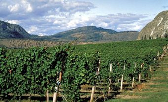
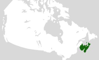
St. Lawrence Lowlands
The St. Lawrence Lowlands (180,000 km2, or 1.8 per cent of Canada's land surface) lie between the Canadian Shield to the north and the Appalachian Region to the east and southeast. This is the smallest of Canada’s seven physiographic regions yet by far the most densely populated (see also Human Geography and Canada; Human Settlement in Canada). Major cities in this region include Windsor, Toronto, Ottawa, Montreal and Quebec City. The St. Lawrence Lowlands can be broken into three subregions: the west, central and east lowlands.
West St. Lawrence Lowland
This subregion lies between the Canadian Shield and Lakes Huron, Erie and Ontario. It consists of a limestone plain (elevation 200–250 masl) that is separated by a broad shale lowland from a broader dolomite and limestone plateau west of Lake Ontario. This plateau is bounded by the Niagara Escarpment. From the escarpment the plateau slopes gently southwest to Lakes Huron and Erie (elevation 173 masl). Glaciation has mantled this subregion with several layers of glacial till, the youngest forming extensive, undulating till plains, often enclosing rolling drumlin fields.
Prominent moraines on the western plateau and north of Lake Ontario mark temporary pauses in the retreat of glaciers between 14,500 and 12,500 years ago. Level clay and sand plains, which were deposited in glacial lakes, fringe the present lakes.
Central St. Lawrence Lowland
This subregion in southeastern Ontario and southern Quebec has undulating topography, developed on sedimentary rocks that are largely masked by glacial and marine deposits. The seven Monteregian Hills (e.g., Mount Royal), which are aligned approximately west–east between the Canadian Shield west of Montreal and the Appalachians, stand at 200–500 masl. They are the exhumed roots of volcanoes that formed as the Atlantic Ocean took shape about 120 million years ago.
Along the Canadian Shield and Appalachian fringes of the lowland, the Champlain Sea deposited sandy terraces (elevation up to 200 masl), which flooded the newly deglaciated lowland approximately 13,000 years ago. Postglacial streams have eroded these terraces to form more broken terrain. The low, rolling moraine trends southwest from near Quebec City to near the Vermont border.
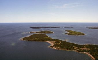
East St. Lawrence Lowland
This is a subregion that widens from the lower St. Lawrence estuary into the Gulf of St. Lawrence and narrows again to the northeast at the Strait of Belle Isle. There are small, isolated low plateaus and plains along the north shore of the Gulf of St. Lawrence, such as Îles de Mingan, a coastal plain at less than 100 metres above sea level in northwestern Newfoundland. There is a larger, undulating plateau on Île d'Anticosti, at 100–200 masl and with a central spine at 300 masl. These fragments have a smooth terrain influenced by flat or gently dipping sedimentary bedrock. Surface conditions may be barren and dry, forested or boggy, depending on surface slope and the influence of coastal winds.