Share on Facebook
 Share on X
 Share by Email
 Share on Google Classroom
After the fall of New France to the British in 1760, cartographers continued to create important maps of Canada. British General James Murray created a map of Quebec in the years before the Treaty of Paris (1763) was signed, and three important British surveyors, namely Samuel Holland, Joseph Desbarres and James Cook, continued thereafter. Settlement in the late 1700s and early 1800s meant maps of townships and the layout of farmland were important. Hydrographic surveys also began during the 1800s, with the charting of the Great Lakes beginning in 1815 and the charting of Georgian Bay in 1883. In 1904, the Department of Marine and Fisheries began officially charting Canadian coastal waters. The preliminary sheets in Canada’s first extensive map series, the Three-Mile Sectional Maps of the Canadian Prairies, appeared in 1892. The series was abandoned in 1956 in favour of the 1:250,000 series of the National Topographic System (established in 1927).
The “Murray Map” of Quebec
Although Quebec fell to the British in 1760, the Treaty of Paris was not signed until February 1763. During the truce, the British army under General James Murray made the first detailed survey of this area, from a point above Montreal downstream to below Quebec City. The “Murray Map,” of which at least five hand-drawn copies were made, was drawn at a scale of 2,000 feet to the inch (1:24,000). It showed much information of military importance, such as the population of villages and the positions of houses, churches and mills. Two originals of this map are held in the National Map Collection in Ottawa.
East Coast
Following the Treaty of Paris, Britain’s vast colonial empire in North America now stretched from the High Arctic to the Gulf of Mexico. Huge areas were essentially unknown to Europeans, with only sketchily charted coasts and a largely unmapped hinterland. For the development of resources and the expansion of trade, the British needed better charts of the harbours and coastal waters and more accurate maps of the continent’s interior.
There were three excellent surveyors serving with the British forces in Canada. Samuel Holland and Joseph Desbarres were army officers; James Cook was the master of a ship in the British fleet.
The work was divided among them: Cook was commissioned to chart the island of Newfoundland and the adjacent Labrador coast. Holland, appointed surveyor general of the Northern District of North America (which included all British holdings north of the Potomac River), concentrated on the Gulf of St. Lawrence, including Prince Edward and Cape Breton islands and the New England coast. DesBarres turned his attention to Nova Scotia, which at that time included present-day New Brunswick.

Many valuable maps and charts resulted. Cook’s charts were of such high quality that his reputation was assured. DesBarres’s major publication was The Atlantic Neptune, a navigational atlas of the east coast of North America containing charts at various scales, coastal views, tide tables and sailing directions. He was allowed to publish the Neptune privately under his own name, although Holland and Cook had been responsible for some of its charts.
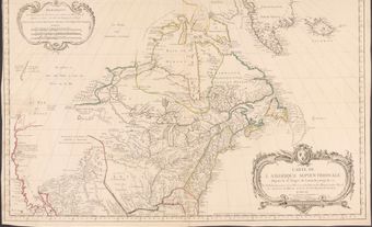
Holland’s publications concentrated on landward mapping, but of course he used the data produced by the surveys of his colleagues. His 1776 map, “A General Map of the Northern British Colonies in America,” drawn at 60 miles to the inch (1:3,801,500), is one of the most important of this period.
Western Interior
In 1760, the land west of the Great Lakes was poorly mapped. The Hudson’s Bay Company (HBC) sent explorers such as Henry Kelsey, Anthony Henday and Samuel Hearne on early exploratory journeys, and Pierre Gaultier de Varennes et de La Vérendrye and his sons had viewed only a fraction of the great land (see also Jean-Baptiste Gaultier de La Vérendrye; Louis-Joseph Gaultier de La Vérendrye). Since none of them could make astronomic observations to fix their positions, they were able to produce only rough sketch maps or route descriptions.
In 1778, the HBC hired Philip Turnor, a trained inland surveyor. Turnor mapped the river routes across the company’s vast holdings. He also trained junior surveyors such as David Thompson and Peter Fidler in the art of field astronomy for position-fixing, and track-surveying for filling in map detail between the “peg points” provided by the astro-fixes.
By this time the HBC was in competition with the North West Company (NWC), which also had surveyors. Shortly after 1778, one of these surveyors, Peter Pond, discovered a practical canoe route from the prairie rivers over the heights of land into the Athabasca and Mackenzie rivers (see Portage La Loche). His 1785 map showing the route led other explorers such as Alexander Mackenzie and John Franklin into the central Arctic.
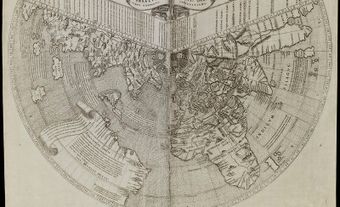
London map publishers made good use of the information flowing out of the fur-trade lands. By examining the resulting maps in their various editions, one can almost see the unfolding of Canada. One in particular stands out: “A Map Exhibiting All the New Discoveries in the Interior Parts of North America,” published by Aaron Arrowsmith in 1795 and updated 19 times until after 1850.
In 1857, two scientific expeditions, one Canadian and the other British, were sent to the Canadian Prairies. The British party under Captain John Palliser spent three years in the West. The Canadian expedition of Simon Dawson and Henry Hind concentrated on the country between Lake Superior and the Red River. Both expeditions gathered topographical and geographical data which were subsequently published on maps and in reports. These maps and reports were influential in the negotiations preceding the purchase of Rupert’s Land.
West Coast
In 1774, Captain Juan Pérez Hernandez and his men aboard the Spanish ship Santiago were the first Europeans to view the Northwest Coast. Pérez had been dispatched there to counter the threat to Spanish sovereignty presented by the Russian expeditions of Bering and Chirikov along the Alaska coastline in 1741. He made several coastal sightings as far north as Dixon Entrance (54° N), but submitted no maps or detailed reports.
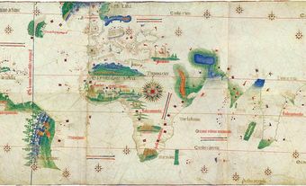
The following year, Spanish hydrographer Juan Francisco de la Bodega y Quadra drew the first chart to show a portion of Canada’s West Coast (see Spanish Exploration). James Cook arrived in 1778 to search for the western end of any channel that might connect with the Arctic Ocean. Samuel Hearne had seen the Arctic Ocean seven years earlier at the mouth of the Coppermine River, but he found no Northwest Passage.
The sovereignty of the West Coast remained in dispute for many years. While diplomatic negotiations were being conducted in Europe during the Nootka Sound Controversy, both Spain and Britain were allowed to make charts of the coast to support their claims.
The British work was done in 1791–92 under Captain George Vancouver. The Spanish hydrographers worked under Dionisio Alcalá-Galiano and Cayetano Valdés. There was no animosity between these groups, and on several occasions they exchanged data to improve the work on both sides.
In 1793, Alexander Mackenzie, a North West Company explorer, travelled from Lake Athabasca to Pacific tidewater at the mouth of the Bella Coola River. During the next half century fur trade employees such as David Thompson, Simon Fraser, Samuel Black and John McLeod made reconnaissance surveys into what is now central British Columbia, increasing the knowledge of this rugged land and producing, in many cases, significant maps recording the topography of the area.
Land surveying began when Hudson’s Bay Company surveyor Joseph Pemberton arrived in Victoria in 1851. In 1858, he completed a map of Victoria. Gold had been found in the Fraser River, and before the year ended, a full-fledged gold rush was in progress (see Fraser River Gold Rush). One section of a detachment of Royal Engineers consisting of 20 surveyors carried out a variety of tasks, including townsite surveys and topographic mapping.
Arctic
The truly remarkable accomplishments in the Arctic were two overland journeys: in 1771, Samuel Hearne reached the mouth of the Coppermine River at 67° N, and in 1789 Alexander Mackenzie descended the river that today bears his name to tidewater at about 68° N. As well, British navigators still sought the Northwest Passage by sea. Their fascination with this navigational goal culminated in the ill-fated Franklin Expedition of 1845.
During the ensuing attempts to find Franklin and his men, the searchers undertook further explorations. The resulting maps revealed the outline of Canada’s mainland coast and disclosed the positions and shorelines of the major islands lying south of Lancaster and Melville sounds. Admiralty charts compiled from the navigational records of these voyages provided the most reliable geographical information about the region until after the Second World War. In fact, some of the aeronautical charts of northern Canada used during the war showed little more than this information.
Township Surveys in Eastern Canada
In the late 1700s, surveyors carried out property surveys so that farmsteads could be established. This work increased greatly after Loyalists began arriving in 1783. Settlement in Nova Scotia was impeded by the lack of a comprehensive land-granting procedure. By contrast, in the Province of Quebec (which included much of present-day southern Ontario), the Loyalist settlement was carried out with military efficiency.
Governor General Frederick Haldimand and Samuel Holland devised a system, comprising townships and lots, for each settler to get a measured portion of land. The surveying was done at minimal cost and marked on the ground. An important requirement was the preparation of a map of each township showing the layout of farm lots and the major topographic features.
Great Lakes Survey
A second type of 19th-century cartographic survey that equalled the township surveys in importance was the hydrographic survey of the Great Lakes. Originally carried out by the British Admiralty, after 1884 it was done by Canadian hydrographers. Captain William F. Owen started the work in 1815 and turned it over to Lieutenant Henry Bayfield the following year.
During the next 40 years, Bayfield supervised the surveying of the Great Lakes, the St. Lawrence and the Nova Scotia coast, and was personally responsible for the high quality of the charts produced.
Compilations
Throughout the 19th century and into the 20th, there were hundreds of maps drawn of parts of Eastern Canada that were simply compilations and re-draftings of the information available from township plans and hydrographic charts. When such maps were extended to cover an area not reached by the township surveyors, the sketch maps of geologists, foresters and even fur traders were used.
The “office-compiled maps” were poor substitutes for true topographic maps, but they were inexpensive to produce, and they were the only large- and medium-scale mapping that Canada could afford.
“County maps” and “county atlases” were very popular. These had a semi-official status because the basic survey data were supplied without charge to private publishers who then added a certain amount of current information. The roads and trails opened by the settlers were shown, as were stores, mills, wharves, churches and, in many cases, individual houses. The scales ranged from 40 chains to 128 chains to the inch (1:31,680 to 1:101,376) depending on the size of the county. To increase sales, the publisher inscribed the name of the owner on each occupied farm lot.
Government agencies also compiled maps from existing survey data. When Samuel Holland died in 1801, Joseph Bouchette became acting surveyor general of Lower Canada and, in 1804, surveyor general. He produced two remarkable maps of his province, the first in 1815 at 2.66 miles to the inch (1:168,530) and a revised version in 1831 at 2.8 miles to the inch (1:177,400). William MacKay’s map of Nova Scotia, published in 1834 at 6 miles to the inch (1:380,150), is a fine example of medium-scale mapping.
The British army produced military route-marching maps and larger-scale “reconnoitering plans” from township surveys by adding details such as the strength of bridges and the billeting capacity of villages. Examples inclue Colonel John Oldfield’s “Map of the Province of Canada” (1843), drawn at 6 miles to the inch (1:380,150), and Major George Baron de Rottenburg’s “Map of the Principal Communications in Canada West” (1850), drawn at 2 miles to the inch (1:126,720).
Did you know?
During the 1850s, Henry Bayfield made another significant contribution to Canadian mapping, instituting telegraph longitude observations at a number of Eastern Canadian cities. By using the commercial telegraph companies’ lines for the exchange of time signals, he was able to very accurately determine the geographical position of an observatory or a public building in each of the cities. This “known position” was then used to correct the mapping of the surrounding area.
Georgian Bay Survey
The British North America Act assigned responsibility for safe navigation in Canadian waters to the federal government. This initially involved the erection and maintenance of navigational aids such as lighthouses and buoys. The charting of Canadian waters started in 1883 in Georgian Bay. Canada had hitherto relied on British Admiralty charts for navigation on the East and West coasts, and on Henry Bayfield's charts of the Great Lakes.
During the late 19th century, navigation on Georgian Bay became very important in national development. Its ports were serving agricultural areas and mining and lumbering industries, and many of these ports were developing industries to supply the westward expansion of railways and the new prairie settlements ( see also History of Settlement in the Canadian Prairies). Navigation on Georgian Bay was of little interest to the US or Britain, so the Georgian Bay Survey was set up within Canada’s Department of Marine and Fisheries.
Coastal Surveys
In 1891, a party from Georgian Bay was sent to Vancouver to survey Burrard Inlet. This survey was the first undertaken by Canada in salt water. In 1904, the Department of Marine and Fisheries began officially charting Canadian coastal waters. The Hydrographic Survey Branch was formed, and the Great Lakes Survey amalgamated with a unit in Public Works that had been doing harbour surveys and a unit in Railways and Canals that had been working on the St. Lawrence and Ottawa rivers. In 1928, it was renamed the Canadian Hydrographic Service (see Hydrography).
Canada has the longest national coastline in the world, much of it the scene of either active shipping or resource development. The towing in 1981 of a barge-mounted ore-concentration plant, 138 m long, from Sorel on the St. Lawrence River to Little Cornwallis Island in the central Arctic could not have been done if good charts had not been available. The voyage of the US supertanker Manhattan, accompanied by the Canadian icebreaker John A. Macdonald, through the Northwest Passage in 1969 also illustrates the vast responsibility of the Canadian Hydrographic Service.
Three Mile and Chief Geographer’s Series
Because of Canada’s size, maps have always been important in the planning and execution of major development projects. The successful settlement of the Prairie West between 1872 and the 1930s was the result of good planning, police supervision, and having each farm lot surveyed and marked on the ground before the arrival of most of the homesteaders.
Surveyors employed by the Department of the Interior marked on the ground the perimeters of the 6-mile (9.7 km) square townships and then the sidelines of each of the 36 sections within the township. They also recorded the positions of major topographic features such as rivers, streams, trails and sloughs. From these notes, draftsmen in Ottawa compiled the sheets of Canada’s first extensive map series, the Three-Mile Sectional Maps of the Canadian Prairies drawn at three miles to the inch (1:190,080).
Did you know?
Series mapping provides detailed mapping at medium or large scale, yet the individual sheets are kept to a manageable size. Because the sheet boundaries conform to a predetermined grid, a number of sheets can be joined together to provide a large map of an extensive area such as a drainage basin, a forest-protection area, a county or even a whole province. Ideally, a country should first be covered by a large-scale topographic series that displays the complete face of the land, including artificial features, relief, drainage pattern and forest cover. In the early days, Canada could afford only the rather simple maps that could be drawn from the field notes sent in by surveyors whose main employment was staking farm lots, not surveying for maps.
The first sheets of the Three-Mile series appeared in 1892. In all, 134 sheets were published, covering approximately 1.4 million km2. Each sheet covered eight townships north to south and from 13 to 15 townships (depending on the latitude) east to west. From 1920 to 1946, 51 of these simple outline maps were converted into true topographic maps through the addition of contours and other details. The series was abandoned in 1956 in favour of the 1:250,000 series (originally drawn at 1:253,430, or 4 miles to the inch) of the National Topographic System.
Did you know?
Simple straight-line surveys were ideal on the flat prairies, but impractical in the Rocky Mountains. When township surveys reached the mountains in 1886, a system was developed using panoramic photographs taken from mountain peaks. A small but important series of mountain maps resulted. The maps themselves were useful, but the technique of mapping from photographs was even more useful because it was adapted to mapping from oblique aerial photographs when these became available after 1925.
The success of the Three-Mile series encouraged the Department of the Interior to begin similar medium-scale, office-compiled mapping for Eastern Canada. The department’s chief geographer gathered the information from the many land surveys that had been made and compiled it into maps of a standard design.
The maps were published at two scales (1:250,000 and 1:500,000), and were known as the Chief Geographer’s Series. The first sheet was published in 1904, and by 1948, when work was stopped, 33 sheets at 1:250,000 and another 25 at 1:500,000 had been published. For many years, they were the most detailed maps available for the settled parts of Eastern Canada.
The original Three-Mile series and the Chief Geographer’s Series were not contoured, and because contoured maps were a military requirement, the Department of Militia and Defence started its own series of true topographic maps in 1904. These were drawn at one mile to the inch (1:63,360), and were modelled on the British Ordnance Survey maps at the same scale. This design, with a few modifications to accommodate the Canadian landscape, proved so successful that it was eventually adopted for the basic topographic mapping of Canada at the 1:50,000 scale.