Article
Agroforestry
Agroforestry is an intensive land management system that integrates the benefits from biological interactions created when trees or shrubs are intentionally grown with crops or livestock.
Signing up enhances your TCE experience with the ability to save items to your personal reading list, and access the interactive map.
Create AccountArticle
Agroforestry is an intensive land management system that integrates the benefits from biological interactions created when trees or shrubs are intentionally grown with crops or livestock.
"https://www.thecanadianencyclopedia.ca/images/tce_placeholder.jpg?v=e9dca980c9bdb3aa11e832e7ea94f5d9" // resources/views/front/categories/view.blade.phphttps://www.thecanadianencyclopedia.ca/images/tce_placeholder.jpg?v=e9dca980c9bdb3aa11e832e7ea94f5d9

Article
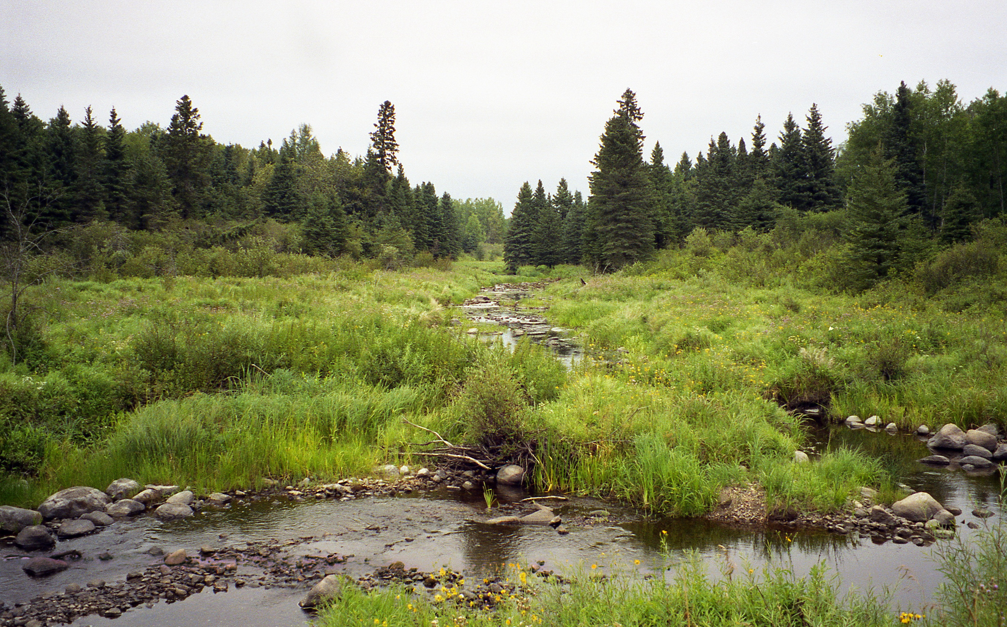
For example, in British Columbia, the Coastal Western Hemlock Zone is one of 14 biogeoclimatic zones. It occupies high precipitation areas up to 1000 m elevation west of the coastal mountains from the Washington to Alaska borders and beyond.
"https://www.thecanadianencyclopedia.ca/images/tce_placeholder.jpg?v=e9dca980c9bdb3aa11e832e7ea94f5d9" // resources/views/front/categories/view.blade.phphttps://www.thecanadianencyclopedia.ca/images/tce_placeholder.jpg?v=e9dca980c9bdb3aa11e832e7ea94f5d9
Article
A biosphere reserve represents one of the world’s important ecosystems and is divided into three zones: a protected core zone (such as a park or wildlife area), a buffer zone around the core, and a transition zone that fosters sustainable economic and cultural activity. The World Network of Biosphere Reserves includes 686 sites around the world, 18 of which are in Canada. The network is part of the larger Man and the Biosphere Program of the United Nations Educational, Scientific and Cultural Organization (UNESCO). Biosphere reserves are designated by UNESCO to help conserve biodiversity, demonstrate sustainable development and build the local community’s capacity to deal with human and environmental issues.
"https://d3d0lqu00lnqvz.cloudfront.net/media/media/0b4a5b26-9047-48ec-97c2-3490843a5b3f.jpg" // resources/views/front/categories/view.blade.phphttps://d3d0lqu00lnqvz.cloudfront.net/media/media/0b4a5b26-9047-48ec-97c2-3490843a5b3f.jpg
Article
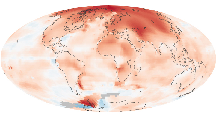
Climate change occurs when long-term weather patterns begin to shift. These periods of change have occurred throughout the Earth’s history over extended periods of time. However, since the Industrial Revolution the world has been warming at an unprecedented rate. Because of this, the current period of climate change is often referred to as “global warming.” Human activities that release heat-trapping greenhouse gases, such as the burning of fossil fuels, are largely responsible for this increased rate of change. The implications of this global increase in temperature are potentially disastrous and include extreme weather events, rising sea levels and loss of habitat for plants, animals and humans. In Canada, efforts to mitigate climate change include phasing-out coal-fired power plants in Ontario and instituting a carbon tax in British Columbia. (This is the full-length entry about climate change. For a plain-language summary, please see Climate Change (Plain-Language Summary).)
"https://d3d0lqu00lnqvz.cloudfront.net/media/media/5ff84049-689a-43d8-8625-462b97b5a67f.jpg" // resources/views/front/categories/view.blade.phphttps://d3d0lqu00lnqvz.cloudfront.net/media/media/5ff84049-689a-43d8-8625-462b97b5a67f.jpg
Macleans
To the uninitiated, it looks no more exciting than a long, thin log of grey plasticene. But to scientists like Jeffrey Fox, a Texas geologist who oversaw its extraction last week from the bottom of a deep bay 16 km north of Victoria, the 9.This article was originally published in Maclean's Magazine on September 2, 1996
"https://www.thecanadianencyclopedia.ca/images/tce_placeholder.jpg?v=e9dca980c9bdb3aa11e832e7ea94f5d9" // resources/views/front/categories/view.blade.phphttps://www.thecanadianencyclopedia.ca/images/tce_placeholder.jpg?v=e9dca980c9bdb3aa11e832e7ea94f5d9
Article
Climate information is used by a variety of people. Building designers must be certain that their structures will withstand the strongest winds and be habitable during temperature extremes. Airlines, when possible, plan their routes to take advantage of the prevailing winds in the upper atmosphere.
"https://www.thecanadianencyclopedia.ca/images/tce_placeholder.jpg?v=e9dca980c9bdb3aa11e832e7ea94f5d9" // resources/views/front/categories/view.blade.phphttps://www.thecanadianencyclopedia.ca/images/tce_placeholder.jpg?v=e9dca980c9bdb3aa11e832e7ea94f5d9
Article
Environment Canada devised the climate severity index to rate a locality's climate according to human comfort and well being. The index has a range from 1 to 100, with a score of 1 representing the least severe climate and 100 the most.
"https://d3d0lqu00lnqvz.cloudfront.net/media/media/ccf0af1a-002e-4354-a12c-75c5dd40fc2e.jpg" // resources/views/front/categories/view.blade.phphttps://d3d0lqu00lnqvz.cloudfront.net/media/media/ccf0af1a-002e-4354-a12c-75c5dd40fc2e.jpg
Article
The study of modern climatology is primarily global in perspective. The main tools used by climatologists are computer models of the atmosphere, ocean and land surface, and data inferred from SATELLITE observations.
"https://www.thecanadianencyclopedia.ca/images/tce_placeholder.jpg?v=e9dca980c9bdb3aa11e832e7ea94f5d9" // resources/views/front/categories/view.blade.phphttps://www.thecanadianencyclopedia.ca/images/tce_placeholder.jpg?v=e9dca980c9bdb3aa11e832e7ea94f5d9
"https://d3d0lqu00lnqvz.cloudfront.net/media/media/f66af222-51e1-4ab7-a091-733bc2476806.jpg" // resources/views/front/categories/view.blade.phphttps://d3d0lqu00lnqvz.cloudfront.net/media/media/f66af222-51e1-4ab7-a091-733bc2476806.jpg

Macleans
This article was originally published in Maclean’s magazine on February 21, 2000. Partner content is not updated. Across the Arctic, the ominous signs are everywhere. With average temperatures in some parts of the Canadian North rising at the rate of about 1° C each decade, glaciers are in retreat. Scientists report a dramatic thinning of the Polar ice cap.
"https://www.thecanadianencyclopedia.ca/images/tce_placeholder.jpg?v=e9dca980c9bdb3aa11e832e7ea94f5d9" // resources/views/front/categories/view.blade.phphttps://www.thecanadianencyclopedia.ca/images/tce_placeholder.jpg?v=e9dca980c9bdb3aa11e832e7ea94f5d9
Macleans
From the outside there was little to distinguish the sleek Toyota Prius from any other car on the streets of Timmins, Ont. But when the driver turned the key, it was clear this was no ordinary sedan. The only sound as the Prius pulled away was the gentle hum of an electric motor.This article was originally published in Maclean's Magazine on July 20, 1998
"https://www.thecanadianencyclopedia.ca/images/tce_placeholder.jpg?v=e9dca980c9bdb3aa11e832e7ea94f5d9" // resources/views/front/categories/view.blade.phphttps://www.thecanadianencyclopedia.ca/images/tce_placeholder.jpg?v=e9dca980c9bdb3aa11e832e7ea94f5d9
Article
Today's greenhouse industry uses the most modern technologies, which allow it to reduce their negative effects on the environment, to considerably improve the energetic efficiency of crops (used energy by unit production) and thus to remain competitive in national and international markets.
"https://d3d0lqu00lnqvz.cloudfront.net/media/media/031a5b27-5e03-4c02-a6dc-a39463809850.jpg" // resources/views/front/categories/view.blade.phphttps://d3d0lqu00lnqvz.cloudfront.net/media/media/031a5b27-5e03-4c02-a6dc-a39463809850.jpg

Article
Hail, precipitation consisting of lumps of ICE, about 5 mm to 10 cm in diameter and about 0.1 g to 1 kg in weight. A 290 g hailstone that fell near Cedoux, Sask, is one of the largest recorded in Canada. The authenticated world record belongs to a 770 g hailstone that fell in Coffeyville, Kansas.
"https://www.thecanadianencyclopedia.ca/images/tce_placeholder.jpg?v=e9dca980c9bdb3aa11e832e7ea94f5d9" // resources/views/front/categories/view.blade.phphttps://www.thecanadianencyclopedia.ca/images/tce_placeholder.jpg?v=e9dca980c9bdb3aa11e832e7ea94f5d9
Article
A heat wave is usually defined as a period of 3 or more consecutive days with temperatures of 32° C or higher. High HUMIDITY is not a requisite, yet most, but not the worst, heat waves are oppressively humid.
"https://www.thecanadianencyclopedia.ca/images/tce_placeholder.jpg?v=e9dca980c9bdb3aa11e832e7ea94f5d9" // resources/views/front/categories/view.blade.phphttps://www.thecanadianencyclopedia.ca/images/tce_placeholder.jpg?v=e9dca980c9bdb3aa11e832e7ea94f5d9
Article
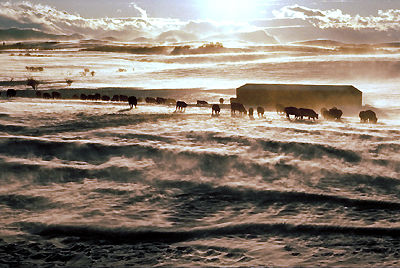
High Arctic Weather Stations, managed by the Monitoring and Science Division, Prairie and Northern Region of Environment Canada, began as the Joint Arctic Weather Stations. The plan for a network of Arctic weather bases was approved by the US on 12 February 1946, and on 28 January 1947 Cabinet formally agreed to participate. Between 1947 and 1950, five sites were selected and built jointly by Canada and the US (at Eureka, Isachsen, Mould Bay, Resolute and Alert) to provide the data required for the understanding and prediction of meteorological phenomena on a hemispheric scale and, more specifically, to improve weather predictions for North America. The meteorological data collected is also used by forecasting offices, airlines, northern shipping, climatology studies and research.
"https://d3d0lqu00lnqvz.cloudfront.net/media/media/7d9ae9bd-0e9d-4d89-b8aa-b9c3b6f79d0c.jpg" // resources/views/front/categories/view.blade.phphttps://d3d0lqu00lnqvz.cloudfront.net/media/media/7d9ae9bd-0e9d-4d89-b8aa-b9c3b6f79d0c.jpg
