Article
Cabbagetown
Cabbagetown, a district in east-central Toronto, the general boundaries of which are the Don River on the east, Parliament St on the west, Gerrard St on the north, and Queen St on the south.
Signing up enhances your TCE experience with the ability to save items to your personal reading list, and access the interactive map.
Create AccountArticle
Cabbagetown, a district in east-central Toronto, the general boundaries of which are the Don River on the east, Parliament St on the west, Gerrard St on the north, and Queen St on the south.
"https://www.thecanadianencyclopedia.ca/images/tce_placeholder.jpg?v=e9dca980c9bdb3aa11e832e7ea94f5d9" // resources/views/front/categories/view.blade.phphttps://www.thecanadianencyclopedia.ca/images/tce_placeholder.jpg?v=e9dca980c9bdb3aa11e832e7ea94f5d9

Article
Cache Creek, BC, incorporated as a village in 1967, population 1040 (2011c), 1056 (2001c). The Village of Cache Creek is located in the dry belt of the southern interior of British Columbia at the junction of highways 1 and 97, 84 km west of KAMLOOPS.
"https://www.thecanadianencyclopedia.ca/images/tce_placeholder.jpg?v=e9dca980c9bdb3aa11e832e7ea94f5d9" // resources/views/front/categories/view.blade.phphttps://www.thecanadianencyclopedia.ca/images/tce_placeholder.jpg?v=e9dca980c9bdb3aa11e832e7ea94f5d9
Article
Caledon, Ontario, incorporated as a city in 1974, population 76,581 (2021 census), 66,502 (2016 census). Northwest of Toronto, Caledon shares its border with nine other municipalities. Together with Brampton and Mississauga, it creates the Region of Peel. Up until recent decades, the area has been relatively rural. Today, however, it is in the midst of urbanization. Throughout history, the Caledon area has been home to different Indigenous groups, namely the Wendat (Huron), Tionontati (Petun), Haudenosaunee and Anishinaabeg, including the Mississaugas of the Credit First Nation. The land is part of the Ajetance Purchase (1818).
"https://d3d0lqu00lnqvz.cloudfront.net/Caledon/CaledonBadlands.jpg" // resources/views/front/categories/view.blade.phphttps://d3d0lqu00lnqvz.cloudfront.net/Caledon/CaledonBadlands.jpg

Article
Calgary, Alberta, incorporated as a city in 1894, population 1,306,784 (2021 census), 1,239,220 (2016 census). The city of Calgary is situated on the Bow River in southern Alberta, about 220 km north of the American border at the meeting point of the Western prairies and mountain foothills. It is the financial centre of western Canada, based on its key role in the development of the region’s oil and gas industry. With its panoramic backdrop of the Rocky Mountains and its historic association with cattle ranching and oil exploration, Calgary is one of Canada’s most identifiable cities.
"https://d3d0lqu00lnqvz.cloudfront.net/media/media/82e124db-7884-44c8-85c5-5696968ef38e.jpg" // resources/views/front/categories/view.blade.phphttps://d3d0lqu00lnqvz.cloudfront.net/media/media/82e124db-7884-44c8-85c5-5696968ef38e.jpg

Article
Cambridge, Ontario, incorporated as a city in 1973, population 138,479 (2021 census), 129,920 (2016 census). Cambridge is located within Waterloo Region and along the Grand River. It was created through the amalgamation of the City of Galt, the Towns of Preston and Hespeler, and parts of North Dumfries and Waterloo townships. Throughout history, the Cambridge area has been home to different Indigenous groups, namely the Neutral, Haudenosaunee and Anishinaabe. The land is covered by the Haldimand Proclamation.
"https://d3d0lqu00lnqvz.cloudfront.net/Cambridge/GrandRiverCambridge.jpg" // resources/views/front/categories/view.blade.phphttps://d3d0lqu00lnqvz.cloudfront.net/Cambridge/GrandRiverCambridge.jpg

Article
Cambridge Bay, Nunavut, incorporated as a hamlet in 1984, population 1608 (2011c), 1477 (2006c). The Hamlet of Cambridge Bay is located on the southeast coast of VICTORIA ISLAND.
"https://www.thecanadianencyclopedia.ca/images/tce_placeholder.jpg?v=e9dca980c9bdb3aa11e832e7ea94f5d9" // resources/views/front/categories/view.blade.phphttps://www.thecanadianencyclopedia.ca/images/tce_placeholder.jpg?v=e9dca980c9bdb3aa11e832e7ea94f5d9
Article
Campbell River, BC, incorporated as a city in 2005, population 31 186 (2011c), 29 572 (2006c). The City of Campbell River was formerly a village (1947) and a district municipality (1964) before receiving civic status in 2005.
"https://www.thecanadianencyclopedia.ca/images/tce_placeholder.jpg?v=e9dca980c9bdb3aa11e832e7ea94f5d9" // resources/views/front/categories/view.blade.phphttps://www.thecanadianencyclopedia.ca/images/tce_placeholder.jpg?v=e9dca980c9bdb3aa11e832e7ea94f5d9
Article
Campbellton, NB, incorporated as a city in 1958, population 7385 (2011c), 7384 (2006c). The City of Campbellton is the administrative centre of Restigouche County. Campbellton is located on the Québec border near the mouth of the RESTIGOUCHE RIVER.
"https://www.thecanadianencyclopedia.ca/images/tce_placeholder.jpg?v=e9dca980c9bdb3aa11e832e7ea94f5d9" // resources/views/front/categories/view.blade.phphttps://www.thecanadianencyclopedia.ca/images/tce_placeholder.jpg?v=e9dca980c9bdb3aa11e832e7ea94f5d9
Article
Campobello Island abuts the border with the US in PASSAMAQUODDY BAY , on the south coast of New Brunswick. Sovereignty over the ruggedly picturesque island was early in dispute, but passed to NB by convention in 1817. The
"https://d3d0lqu00lnqvz.cloudfront.net/media/media/364b3dab-46ce-450c-8e44-125fe9dd20d3.jpg" // resources/views/front/categories/view.blade.phphttps://d3d0lqu00lnqvz.cloudfront.net/media/media/364b3dab-46ce-450c-8e44-125fe9dd20d3.jpg

Article
Camrose, Alberta, incorporated as a city in 1955, population 18,742 (2016 census), 17,286 (2011 census). The city of Camrose, located 97 km southeast of Edmonton, is a distributing, medical, government and manufacturing centre for a rich, mixed-farming area.
"https://www.thecanadianencyclopedia.ca/images/tce_placeholder.jpg?v=e9dca980c9bdb3aa11e832e7ea94f5d9" // resources/views/front/categories/view.blade.phphttps://www.thecanadianencyclopedia.ca/images/tce_placeholder.jpg?v=e9dca980c9bdb3aa11e832e7ea94f5d9
Article
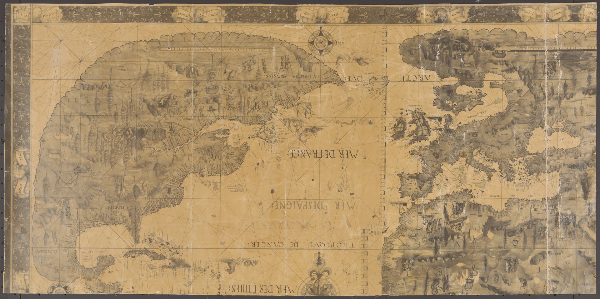
The name “Canada,” is derived from the Iroquoian word kanata, meaning a village or settlement. On 13 August 1535, as Jacques Cartier was nearing Île d'Anticosti, two Indigenous youths he was bringing back from France informed him that the route to Canada (“chemin de Canada”) lay to the south of the island. By Canada they meant the village of Stadacona, on the future site of Quebec City. Cartier used the word in that sense, but also referred to “the province of Canada,” meaning the area subject to Donnacona, chief at Stadacona. The name was soon applied to a much larger region. The “Harleian” world map of c. 1547, the first to show the discoveries made on Cartier's second voyage, applied it to an area north of the gulf and river St. Lawrence. By 1550 maps were also placing the name south of the river. (See also Cartography in Canada: 1500s.)
"https://d3d0lqu00lnqvz.cloudfront.net/media/new_article_images/CartographyInCanada1500s/DesceliersMap1546.jpg" // resources/views/front/categories/view.blade.phphttps://d3d0lqu00lnqvz.cloudfront.net/media/new_article_images/CartographyInCanada1500s/DesceliersMap1546.jpg
Article
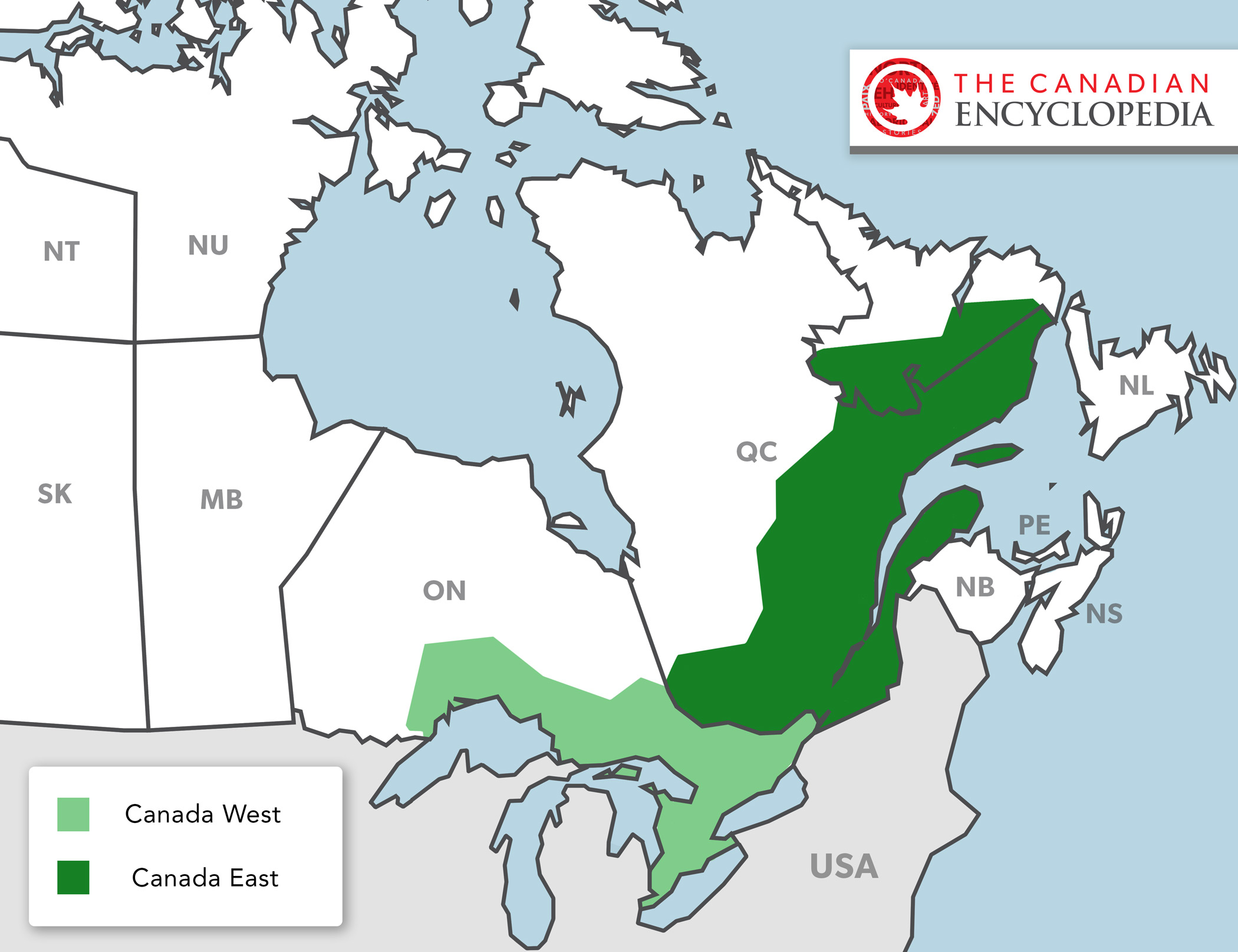
In 1841, Britain united the colonies of Upper and Lower Canada into the Province of Canada. This was in response to the violent rebellions of 1837–38. The Durham Report (1839) laid out the guidelines to create the new colony with the Act of Union in 1840. The Province of Canada was made up of Canada West (formerly Upper Canada) and Canada East (formerly Lower Canada). The two regions were governed jointly until Confederation in 1867. Canada West then became Ontario and Canada East became Quebec.
"https://d3d0lqu00lnqvz.cloudfront.net/media/new_article_images/PoliticsInOntario/Map_Canada_West_East.jpg" // resources/views/front/categories/view.blade.phphttps://d3d0lqu00lnqvz.cloudfront.net/media/new_article_images/PoliticsInOntario/Map_Canada_West_East.jpg
Article
In 1841, Britain united the colonies of Upper and Lower Canada into the Province of Canada. This was in response to the violent rebellions of 1837–38. The Durham Report (1839) laid out the guidelines to create the new colony with the Act of Union in 1840. The Province of Canada was made up of Canada West (formerly Upper Canada) and Canada East (formerly Lower Canada). The two regions were governed jointly until Confederation in 1867. Canada West then became Ontario and Canada East became Quebec.
"https://www.thecanadianencyclopedia.ca/images/tce_placeholder.jpg?v=e9dca980c9bdb3aa11e832e7ea94f5d9" // resources/views/front/categories/view.blade.phphttps://www.thecanadianencyclopedia.ca/images/tce_placeholder.jpg?v=e9dca980c9bdb3aa11e832e7ea94f5d9
Article
The Candiac Development Corporation (now Developpements urbain Candiac), a group of Canadian and European investors, owned utilized farmland in the parishes of Saint-Constant, Delson, Saint-Philippe and the town of LA PRAIRIE.
"https://d3d0lqu00lnqvz.cloudfront.net/media/media/c7208d84-cf2c-4a5d-8d23-c8d52681a469.jpg" // resources/views/front/categories/view.blade.phphttps://d3d0lqu00lnqvz.cloudfront.net/media/media/c7208d84-cf2c-4a5d-8d23-c8d52681a469.jpg

Article
Canmore, Alta, incorporated as a town in 1966, population 12 288 (2011c), 12 039 (2006c). The Town of Canmore is located in the foothills of the Rocky Mountains, five km east of BANFF NATIONAL PARK.
"https://www.thecanadianencyclopedia.ca/images/tce_placeholder.jpg?v=e9dca980c9bdb3aa11e832e7ea94f5d9" // resources/views/front/categories/view.blade.phphttps://www.thecanadianencyclopedia.ca/images/tce_placeholder.jpg?v=e9dca980c9bdb3aa11e832e7ea94f5d9