Article
Athabasca Pass
Athabasca Pass, elevation 1,748 m, is situated on the extreme southwest boundary of Jasper National Park, on the British Columbia-Alberta border.
Signing up enhances your TCE experience with the ability to save items to your personal reading list, and access the interactive map.
Create AccountArticle
Athabasca Pass, elevation 1,748 m, is situated on the extreme southwest boundary of Jasper National Park, on the British Columbia-Alberta border.
"https://www.thecanadianencyclopedia.ca/images/tce_placeholder.jpg?v=e9dca980c9bdb3aa11e832e7ea94f5d9" // resources/views/front/categories/view.blade.phphttps://www.thecanadianencyclopedia.ca/images/tce_placeholder.jpg?v=e9dca980c9bdb3aa11e832e7ea94f5d9

Article
The Athabasca River is the longest river in Alberta (1,538 km). The first 168 km (located in Jasper National Park) are designated as a Canadian Heritage River. As a tributary to the Mackenzie River, water flowing on the Athabasca River eventually drains into the Arctic Ocean. River flow is highest during the summer and lowest during winter, and it is ice-covered from mid-November to mid-April.
"https://d3d0lqu00lnqvz.cloudfront.net/media/media/19887911-e879-4485-a00f-6bfd76cfe28c.jpg" // resources/views/front/categories/view.blade.phphttps://d3d0lqu00lnqvz.cloudfront.net/media/media/19887911-e879-4485-a00f-6bfd76cfe28c.jpg

Article
Atlin Lake, 775 km2, elev 668 m, is a long, narrow lake in northwestern BC touching the Yukon border. The source of the Yukon River, it was inundated by prospectors during the Klondike Gold Rush 1897-98. The town of Atlin is on the E shore.
"https://www.thecanadianencyclopedia.ca/images/tce_placeholder.jpg?v=e9dca980c9bdb3aa11e832e7ea94f5d9" // resources/views/front/categories/view.blade.phphttps://www.thecanadianencyclopedia.ca/images/tce_placeholder.jpg?v=e9dca980c9bdb3aa11e832e7ea94f5d9
Article
Attawapiskat River, 748 km long, formed by the confluence of the Pineimuta, Trading and Otoskwin rivers at Attawapiskat Lake, in northeastern Ontario, flows east, jogs north and runs east to the flatland by James Bay. Its drainage area is 50 200 km2 and its mean discharge 626 m3/s.
"https://www.thecanadianencyclopedia.ca/images/tce_placeholder.jpg?v=e9dca980c9bdb3aa11e832e7ea94f5d9" // resources/views/front/categories/view.blade.phphttps://www.thecanadianencyclopedia.ca/images/tce_placeholder.jpg?v=e9dca980c9bdb3aa11e832e7ea94f5d9
Article
Avalon Peninsula, 9220 km2, is a spreading peninsula thrust out into the rich fishing grounds of the north Atlantic, forming the southeast corner of insular Newfoundland.
"https://d3d0lqu00lnqvz.cloudfront.net/media/media/9174fc30-b6b6-4ab0-b12f-9fbca2dab7b8.jpg" // resources/views/front/categories/view.blade.phphttps://d3d0lqu00lnqvz.cloudfront.net/media/media/9174fc30-b6b6-4ab0-b12f-9fbca2dab7b8.jpg

Article
Axel Heiberg Island, Nunavut, is Canada’s second northernmost island, located in the High Arctic approximately 1,200 km from the North Pole.
"https://d3d0lqu00lnqvz.cloudfront.net/media/media/0dc72b02-1baf-4d5c-b7f6-1e64d9a7440c.JPG" // resources/views/front/categories/view.blade.phphttps://d3d0lqu00lnqvz.cloudfront.net/media/media/0dc72b02-1baf-4d5c-b7f6-1e64d9a7440c.JPG

Article
Back River, 974 km long, rises in Contwoyto Lake, north of Great Slave Lake, NWT, and flows northeast across the Barren Lands of Nunavut to Chantrey Inlet, south of King William Island.
"https://d3d0lqu00lnqvz.cloudfront.net/media/media/a482d857-2391-4492-83fe-ea3938b7020d.jpg" // resources/views/front/categories/view.blade.phphttps://d3d0lqu00lnqvz.cloudfront.net/media/media/a482d857-2391-4492-83fe-ea3938b7020d.jpg

Article
Badlands are dramatic landforms characterized by a network of deep, narrow and winding gullies, along with occasional hoodoo rocks. Their steep, barren slopes provide striking evidence of the force of erosion by wind and water — a source of continual change in their terrain.
"https://d3d0lqu00lnqvz.cloudfront.net/media/media/251b5d36-82cc-4ec1-80e8-471cfd59098a.jpg" // resources/views/front/categories/view.blade.phphttps://d3d0lqu00lnqvz.cloudfront.net/media/media/251b5d36-82cc-4ec1-80e8-471cfd59098a.jpg

Article
Circulation is generally anticlockwise; off Greenland, relatively warm, salty water moves north, while along Baffin Island, cold, fresher water originating from the Arctic Ocean flows south. Icebergs, formed by calving off the Greenland glaciers, appear year-round, but are most numerous in August.
"https://d3d0lqu00lnqvz.cloudfront.net/media/media/9dc94550-4e3e-4264-9c68-78b71ac3e6e1.jpg" // resources/views/front/categories/view.blade.phphttps://d3d0lqu00lnqvz.cloudfront.net/media/media/9dc94550-4e3e-4264-9c68-78b71ac3e6e1.jpg

Article
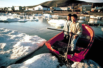
Baffin Island, Nunavut, 507,451 km2, 1,500 km long and 200–700 km wide, is the largest island in Canada and the fifth-largest island in the world.
"https://d3d0lqu00lnqvz.cloudfront.net/media/media/8d221872-5616-49d0-a982-986cd0455d73.jpg" // resources/views/front/categories/view.blade.phphttps://d3d0lqu00lnqvz.cloudfront.net/media/media/8d221872-5616-49d0-a982-986cd0455d73.jpg
Article
Balaklava Island, 8 km2, situated off the N coast of Vancouver Island, is located between Nigel and Hurst islands, and is flanked by Queen Charlotte Str in the N and Goletas Channel in the S. It is 15 km NW of Port Hardy, BC. This tiny island has a lighthouse at Scarlett Pt (1905) to aid shipping.
"https://www.thecanadianencyclopedia.ca/images/tce_placeholder.jpg?v=e9dca980c9bdb3aa11e832e7ea94f5d9" // resources/views/front/categories/view.blade.phphttps://www.thecanadianencyclopedia.ca/images/tce_placeholder.jpg?v=e9dca980c9bdb3aa11e832e7ea94f5d9
Article
Banks Island, 70 028 km2, fifth-largest island in Canada, is the westernmost island of the Arctic Archipelago.
"https://d3d0lqu00lnqvz.cloudfront.net/media/media/79d1e122-c898-4f67-8500-8c2d799e7700.jpg" // resources/views/front/categories/view.blade.phphttps://d3d0lqu00lnqvz.cloudfront.net/media/media/79d1e122-c898-4f67-8500-8c2d799e7700.jpg

Article
Bathurst Inlet, a southeastern extension of Coronation Gulf, penetrating the arctic shore for some 200 km. The hamlet of Bathurst Inlet is located at the mouth of the Burnside River, which drains Contwoyto Lake to the southwest.
"https://d3d0lqu00lnqvz.cloudfront.net/media/media/b504d03a-1419-4bf4-ab27-00b5e8cc89a0.jpg" // resources/views/front/categories/view.blade.phphttps://d3d0lqu00lnqvz.cloudfront.net/media/media/b504d03a-1419-4bf4-ab27-00b5e8cc89a0.jpg

Article
Bathurst Island, 16 042 km2 and over 18 000 km2 including its offshore islands, is located in the Arctic Archipelago. The present position of the North magnetic pole is near its northern end.
"https://www.thecanadianencyclopedia.ca/images/tce_placeholder.jpg?v=e9dca980c9bdb3aa11e832e7ea94f5d9" // resources/views/front/categories/view.blade.phphttps://www.thecanadianencyclopedia.ca/images/tce_placeholder.jpg?v=e9dca980c9bdb3aa11e832e7ea94f5d9
Article
Bay d'Espoir is a fjord-like arm of Hermitage Bay on Newfoundland’s south coast. More than 50 km from mouth to head, Bay d'Espoir — French for “hope” — is ice-free, with sheer cliffs and steep-sided hills rising 180 to 300 m. The bay divides into two principal arms to the north and northeast of Bois Island. Because of the tremendous watershed from a surrounding glacial plateau, the area is the site of a hydroelectric generating plant. Opened in 1967, today the plant has a generating capacity of more than 600 MW.
"https://d3d0lqu00lnqvz.cloudfront.net/media/media/c5f9ff74-e069-4e91-a4d9-baed4c78f3ba.jpg" // resources/views/front/categories/view.blade.phphttps://d3d0lqu00lnqvz.cloudfront.net/media/media/c5f9ff74-e069-4e91-a4d9-baed4c78f3ba.jpg
