Article
Wilkie
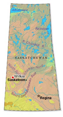
Wilkie, Sask, incorporated as a town in 1911, population 1301 (2011c), 1222 (2006c). The Town of Wilkie is located in east-central Saskatchewan 160 km west of Saskatoon. Wilkie developed as a stopping place on the Medicine Hat
Signing up enhances your TCE experience with the ability to save items to your personal reading list, and access the interactive map.
Create AccountArticle
Wilkie, Sask, incorporated as a town in 1911, population 1301 (2011c), 1222 (2006c). The Town of Wilkie is located in east-central Saskatchewan 160 km west of Saskatoon. Wilkie developed as a stopping place on the Medicine Hat
"https://d3d0lqu00lnqvz.cloudfront.net/media/media/3396144b-3b37-4b9b-891f-44674a7eaea6.jpg" // resources/views/front/categories/view.blade.phphttps://d3d0lqu00lnqvz.cloudfront.net/media/media/3396144b-3b37-4b9b-891f-44674a7eaea6.jpg
Article
Williams Lake, BC, incorporated as a city in 1929, population 10 832 (2011c), 10 744 (2006c). The City of Williams Lake is located in the Cariboo country of central British Columbia, 545 km northeast of Vancouver.
"https://www.thecanadianencyclopedia.ca/images/tce_placeholder.jpg?v=e9dca980c9bdb3aa11e832e7ea94f5d9" // resources/views/front/categories/view.blade.phphttps://www.thecanadianencyclopedia.ca/images/tce_placeholder.jpg?v=e9dca980c9bdb3aa11e832e7ea94f5d9

Article
Williston Lake, 1761 km2, is the largest freshwater body in BC. Created in 1968 as the reservoir of the W.A.C.
"https://www.thecanadianencyclopedia.ca/images/tce_placeholder.jpg?v=e9dca980c9bdb3aa11e832e7ea94f5d9" // resources/views/front/categories/view.blade.phphttps://www.thecanadianencyclopedia.ca/images/tce_placeholder.jpg?v=e9dca980c9bdb3aa11e832e7ea94f5d9
Article
Wilton, Saskatchewan, incorporated as a rural municipality in 1909, population 1,629 (2016census), 1,494 (2011 census). The Rural Municipality of Wilton is located just east of Lloydminsteron the Saskatchewan-Alberta border. The main communities in the rural municipality are the town of Lashburn and the village of Marshall.
"https://www.thecanadianencyclopedia.ca/images/tce_placeholder.jpg?v=e9dca980c9bdb3aa11e832e7ea94f5d9" // resources/views/front/categories/view.blade.phphttps://www.thecanadianencyclopedia.ca/images/tce_placeholder.jpg?v=e9dca980c9bdb3aa11e832e7ea94f5d9
Article
Later, concerts were given in the hotel's ballroom, which also bore the name Windsor Hall. Among concerts held in the ballroom known as the Ladies Ordinary of the Windsor were those by the Dubois String Quartet, who played there regularly from 1915 until 1927.
"https://d3d0lqu00lnqvz.cloudfront.net/media/media/44536990-4119-4245-a4f1-59275f935d4a.jpg" // resources/views/front/categories/view.blade.phphttps://d3d0lqu00lnqvz.cloudfront.net/media/media/44536990-4119-4245-a4f1-59275f935d4a.jpg

Article
Windsor, NS, incorporated as a town in 1878, population 3785 (2011c), 3709 (2006c). The Town of Windsor is located in central Nova Scotia, at the mouth of the Avon and St Croix rivers.
"https://d3d0lqu00lnqvz.cloudfront.net/media/media/e2f6b892-e47d-4981-9656-0c2e345b41db.jpg" // resources/views/front/categories/view.blade.phphttps://d3d0lqu00lnqvz.cloudfront.net/media/media/e2f6b892-e47d-4981-9656-0c2e345b41db.jpg
Article
Windsor, Ontario, incorporated as a city in 1892, population 217,188 (2016 census), 210,891 (2011 census). The city of Windsor is Canada’s southernmost city. It is located on the Detroit River in the extreme southwest corner of the province. Lying directly south of Detroit on the rich agricultural peninsula nestled between Lakes Erie and St. Clair, Windsor is an international gateway through which millions of foreign visitors enter the country each year.
"https://d3d0lqu00lnqvz.cloudfront.net/media/media/2979e12e-b21b-4a11-985a-0ef5de6ba61c.jpg" // resources/views/front/categories/view.blade.phphttps://d3d0lqu00lnqvz.cloudfront.net/media/media/2979e12e-b21b-4a11-985a-0ef5de6ba61c.jpg

Article
Southern Ontario city across the Detroit River from Detroit, Mich. First settled in 1834, it was established as the western terminus of the Great Western Railway in 1854 and was incorporated as a town in 1858 and as a city in 1892.
"https://www.thecanadianencyclopedia.ca/images/tce_placeholder.jpg?v=e9dca980c9bdb3aa11e832e7ea94f5d9" // resources/views/front/categories/view.blade.phphttps://www.thecanadianencyclopedia.ca/images/tce_placeholder.jpg?v=e9dca980c9bdb3aa11e832e7ea94f5d9
Article
Winisk River, 475 km long, rises in Wunnummin Lake in the Kenora District of northern Ontario.
"https://www.thecanadianencyclopedia.ca/images/tce_placeholder.jpg?v=e9dca980c9bdb3aa11e832e7ea94f5d9" // resources/views/front/categories/view.blade.phphttps://www.thecanadianencyclopedia.ca/images/tce_placeholder.jpg?v=e9dca980c9bdb3aa11e832e7ea94f5d9
Article
Winkler, Manitoba, incorporated as a city in 2002, population 10 670 (2011c), 9106 (2006c). The City of Winkler is located in the Pembina Valley region, 115 km southwest of Winnipeg and 22 km north of the US international boundary.
"https://www.thecanadianencyclopedia.ca/images/tce_placeholder.jpg?v=e9dca980c9bdb3aa11e832e7ea94f5d9" // resources/views/front/categories/view.blade.phphttps://www.thecanadianencyclopedia.ca/images/tce_placeholder.jpg?v=e9dca980c9bdb3aa11e832e7ea94f5d9
Article
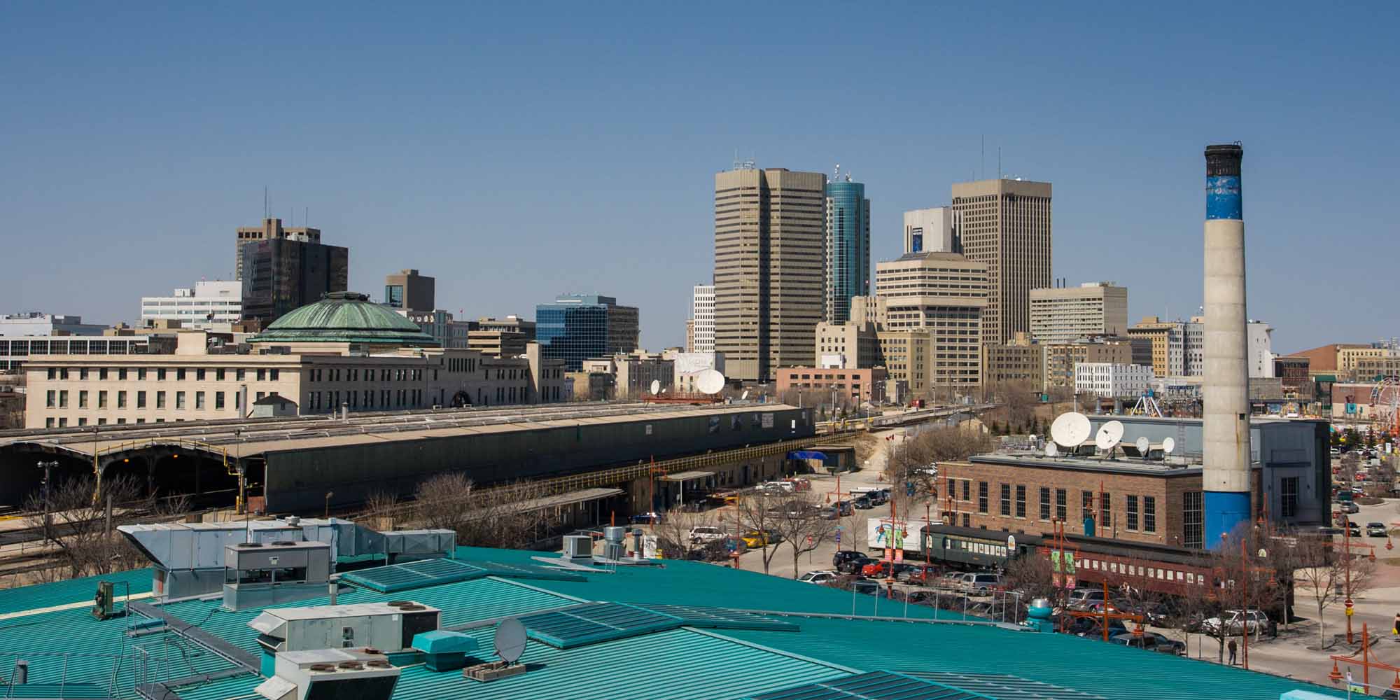
Winnipeg, Manitoba, incorporated as a city in 1873, population 749,607 (2021 census), 705,244 (2016 census). The city of Winnipeg is the capital and largest city of Manitoba, and is located at the confluence of the Red River and Assiniboine River 100 km north of the Minnesota border. The name is derived from the Cree name for Lake Winnipeg, 65 km north, win-nipi, meaning "murky water." Winnipeg is an important economic and cultural centre for the Prairies. Lying midway between the Atlantic and Pacific Oceans, it has been called "Bull's Eye of the Dominion," and because of its location between the Canadian Shield and the prairie, "Gateway to the West."
"https://d3d0lqu00lnqvz.cloudfront.net/media/media/13f6cecb-3eb8-4e49-bb41-138036eb158b.jpg" // resources/views/front/categories/view.blade.phphttps://d3d0lqu00lnqvz.cloudfront.net/media/media/13f6cecb-3eb8-4e49-bb41-138036eb158b.jpg
Article
Winnipeg Auditorium. Winnipeg's main concert hall complex from 1932, when it opened, until 1968, when it was supplanted in that function by the Manitoba Centennial Concert Hall. It was designed jointly by three architectural firms - Northwood & Chivers, Pratt & Ross, and J.N.
"https://www.thecanadianencyclopedia.ca/images/tce_placeholder.jpg?v=e9dca980c9bdb3aa11e832e7ea94f5d9" // resources/views/front/categories/view.blade.phphttps://www.thecanadianencyclopedia.ca/images/tce_placeholder.jpg?v=e9dca980c9bdb3aa11e832e7ea94f5d9
Article
Manitoba's capital city, Winnipeg is located at the junction of the Red and Assiniboine rivers on a site once known to the Cree as “Murky Water.” Fort Rouge was established there in 1738 by Pierre de La Vérendrye, a fur trader and explorer.
"https://d3d0lqu00lnqvz.cloudfront.net/TCE_placeholder.png" // resources/views/front/categories/view.blade.phphttps://d3d0lqu00lnqvz.cloudfront.net/TCE_placeholder.png

Article
Winnipeg River, 813 km long (to head of Firesteel River), issues from the north end of Lake of the Woods and flows northwest to Lake Winnipeg.
"https://www.thecanadianencyclopedia.ca/images/tce_placeholder.jpg?v=e9dca980c9bdb3aa11e832e7ea94f5d9" // resources/views/front/categories/view.blade.phphttps://www.thecanadianencyclopedia.ca/images/tce_placeholder.jpg?v=e9dca980c9bdb3aa11e832e7ea94f5d9
Article
Wolfville, NS, incorporated as a town in 1893, population 4269 (2011c), 3772 (2006c). The Town of Wolfville is located on Minas Basin, 75 km northwest of Halifax.
"https://www.thecanadianencyclopedia.ca/images/tce_placeholder.jpg?v=e9dca980c9bdb3aa11e832e7ea94f5d9" // resources/views/front/categories/view.blade.phphttps://www.thecanadianencyclopedia.ca/images/tce_placeholder.jpg?v=e9dca980c9bdb3aa11e832e7ea94f5d9