Cities & Populated Places | The Canadian Encyclopedia

Browse "Cities & Populated Places"

Displaying 346-360 of 963 results
  • Article

    Hanover (Man)

    Hanover, Manitoba, incorporated as a rural municipality in 1881, population 14 026 (2011c), 11 871 (2006c). The Rural Municipality of Hanover is located southeast of Winnipeg, encompasses the communities of Blumenort, Grunthal, Kleefeld, Mitchell, New Bothwell, Randolph and Sarto.

    "https://www.thecanadianencyclopedia.ca/images/tce_placeholder.jpg?v=e9dca980c9bdb3aa11e832e7ea94f5d9" // resources/views/front/categories/view.blade.php
    
    https://www.thecanadianencyclopedia.ca/images/tce_placeholder.jpg?v=e9dca980c9bdb3aa11e832e7ea94f5d9 Hanover (Man)
  • Article

    Hanover (Ont)

    Hanover, Ont, incorporated as a town in 1904, population 7490 (2011c), 7147 (2006c). The Town of Hanover is located 70 km southwest of OWEN SOUND on the Saugeen River.

    "https://d3d0lqu00lnqvz.cloudfront.net/media/media/0ae492cf-0c8f-489c-9da4-cdd28d818051.jpg" // resources/views/front/categories/view.blade.php
    
    https://d3d0lqu00lnqvz.cloudfront.net/media/media/0ae492cf-0c8f-489c-9da4-cdd28d818051.jpg Hanover (Ont)
  • Article

    Happy Valley-Goose Bay

    Happy Valley-Goose Bay, Newfoundland and Labrador, incorporated as a town in 1973, population 8,109 (2016 census), 7,552 (2011 census). The town of Happy Valley-Goose Bay is the result of the amalgamation of two towns situated at the western end of Hamilton Inlet, Labrador. The community began with the construction of an air base during the Second World War. It remains home to a Canadian Forces Base and a small civilian population.

    "https://d3d0lqu00lnqvz.cloudfront.net/media/media/dcdb9156-1ed7-43df-b8d3-36f7d617cd41.jpg" // resources/views/front/categories/view.blade.php
    
    https://d3d0lqu00lnqvz.cloudfront.net/media/media/dcdb9156-1ed7-43df-b8d3-36f7d617cd41.jpg Happy Valley-Goose Bay
  • Article

    Harbour Breton

    Harbour Breton, NL, incorporated as a town in 1952, population 1711 (2011c), 1877 (2006c). The Town of Harbour Breton is situated around a protected harbour near the mouth of Fortune Bay on Newfoundland's south coast.

    "https://www.thecanadianencyclopedia.ca/images/tce_placeholder.jpg?v=e9dca980c9bdb3aa11e832e7ea94f5d9" // resources/views/front/categories/view.blade.php
    
    https://www.thecanadianencyclopedia.ca/images/tce_placeholder.jpg?v=e9dca980c9bdb3aa11e832e7ea94f5d9 Harbour Breton
  • Article

    Harbour Grace

    Harbour Grace, NL, incorporated as a town in 1945, population 3131 (2011c), 3074 (2006c). The Town of Harbour Grace, with its commodious harbour in western Conception Bay, was named for the French Havre de Grâce.

    "https://www.thecanadianencyclopedia.ca/images/tce_placeholder.jpg?v=e9dca980c9bdb3aa11e832e7ea94f5d9" // resources/views/front/categories/view.blade.php
    
    https://www.thecanadianencyclopedia.ca/images/tce_placeholder.jpg?v=e9dca980c9bdb3aa11e832e7ea94f5d9 Harbour Grace
  • Article

    Hartland

    Hartland, NB, incorporated as a town in 1918, population 947 (2011c), 947 (2006c). The Town of Hartland is located at the mouth of Becaguimec Stream, 124 km upriver from Fredericton on the SAINT JOHN RIVER.

    "https://d3d0lqu00lnqvz.cloudfront.net/media/media/47b24fcb-cb02-4988-ac93-8d8199dd5a7f.jpg" // resources/views/front/categories/view.blade.php
    
    https://d3d0lqu00lnqvz.cloudfront.net/media/media/47b24fcb-cb02-4988-ac93-8d8199dd5a7f.jpg Hartland
  • Article

    Hawkesbury

    Hawkesbury, Ontario, incorporated as a town in 1896, population 10,263 (2016 census), 10,551 (2011 census). The town of Hawkesbury is located on the Ottawa River, 95 km east of Ottawa.

    "https://www.thecanadianencyclopedia.ca/images/tce_placeholder.jpg?v=e9dca980c9bdb3aa11e832e7ea94f5d9" // resources/views/front/categories/view.blade.php
    
    https://www.thecanadianencyclopedia.ca/images/tce_placeholder.jpg?v=e9dca980c9bdb3aa11e832e7ea94f5d9 Hawkesbury
  • Article

    Hay River

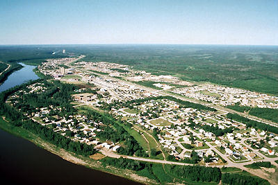
    Hay River, Northwest Territories, incorporated as a town in 1963, population 3,169 (2021 census), 3,528 (2016 census). The town of Hay River is located on the south shore of Great Slave Lake at the mouth of the Hay River, about 200 air km southwest of Yellowknife.

    "https://d3d0lqu00lnqvz.cloudfront.net/media/media/033734fa-dbda-414b-a290-f459d2a67b5a.jpg" // resources/views/front/categories/view.blade.php
    
    https://d3d0lqu00lnqvz.cloudfront.net/media/media/033734fa-dbda-414b-a290-f459d2a67b5a.jpg Hay River
  • Article

    Hazelton

    Hazelton, British Columbia, incorporated as a village in 1956, population 270 (2011c), 293 (2006c). The Village of Hazelton is situated at the confluence of the Skeena and Bulkley rivers. The townsite was laid out by Edgar DEWDNEY in 1871 next to the GITKSAN village of Gitanmaax.

    "https://www.thecanadianencyclopedia.ca/images/tce_placeholder.jpg?v=e9dca980c9bdb3aa11e832e7ea94f5d9" // resources/views/front/categories/view.blade.php
    
    https://www.thecanadianencyclopedia.ca/images/tce_placeholder.jpg?v=e9dca980c9bdb3aa11e832e7ea94f5d9 Hazelton
  • Article

    Hearst

    Hearst, Ont, incorporated as a town in 1922, population 5090 (2011c), 5620 (2006c). The Town of Hearst is situated in the Cochrane District of northeastern Ontario on the Mattawishkwia River, 260 km northwest of TIMMINS.

    "https://www.thecanadianencyclopedia.ca/images/tce_placeholder.jpg?v=e9dca980c9bdb3aa11e832e7ea94f5d9" // resources/views/front/categories/view.blade.php
    
    https://www.thecanadianencyclopedia.ca/images/tce_placeholder.jpg?v=e9dca980c9bdb3aa11e832e7ea94f5d9 Hearst
  • Article

    Heart's Content

    Heart's Content, NL, incorporated as a town in 1967, population 418 (2011c), 418 (2006c). The Town of Heart's Content is a fishing community on a protected, urn-shaped harbour in eastern Trinity Bay.

    "https://www.thecanadianencyclopedia.ca/images/tce_placeholder.jpg?v=e9dca980c9bdb3aa11e832e7ea94f5d9" // resources/views/front/categories/view.blade.php
    
    https://www.thecanadianencyclopedia.ca/images/tce_placeholder.jpg?v=e9dca980c9bdb3aa11e832e7ea94f5d9 Heart's Content
  • Article

    Hespeler

    Hespeler, Ont, is located in southwestern Ontario, on the Speed River.

    "https://www.thecanadianencyclopedia.ca/images/tce_placeholder.jpg?v=e9dca980c9bdb3aa11e832e7ea94f5d9" // resources/views/front/categories/view.blade.php
    
    https://www.thecanadianencyclopedia.ca/images/tce_placeholder.jpg?v=e9dca980c9bdb3aa11e832e7ea94f5d9 Hespeler
  • Article

    High Level

    High Level, Alta, incorporated as a town in 1983, population 3641 (2011c), 3887 (2006c). The Town of High Level is located 250 km north of the town of PEACE RIVER and was named for a high expanse of land separating the Hay and PEACE river systems.

    "https://www.thecanadianencyclopedia.ca/images/tce_placeholder.jpg?v=e9dca980c9bdb3aa11e832e7ea94f5d9" // resources/views/front/categories/view.blade.php
    
    https://www.thecanadianencyclopedia.ca/images/tce_placeholder.jpg?v=e9dca980c9bdb3aa11e832e7ea94f5d9 High Level
  • Article

    High Prairie

    High Prairie, Alta, incorporated as a village in 1945 and as a town in 1950, population 2600 (2011c), 2785 (2006c). Located on the south edge of the Peace River region, the Town of High Prairie is 365 km northwest of Edmonton and 200 km northeast of Grande Prairie.

    "https://d3d0lqu00lnqvz.cloudfront.net/media/media/430178ab-66e7-4f64-a004-dcce0b8ac820.jpg" // resources/views/front/categories/view.blade.php
    
    https://d3d0lqu00lnqvz.cloudfront.net/media/media/430178ab-66e7-4f64-a004-dcce0b8ac820.jpg High Prairie
  • Article

    Hinton

    Hinton, Alta, incorporated as a town in 1958, population 9640 (2011c), 9738 (2006c).

    "https://www.thecanadianencyclopedia.ca/images/tce_placeholder.jpg?v=e9dca980c9bdb3aa11e832e7ea94f5d9" // resources/views/front/categories/view.blade.php
    
    https://www.thecanadianencyclopedia.ca/images/tce_placeholder.jpg?v=e9dca980c9bdb3aa11e832e7ea94f5d9 Hinton