Article
Laidlaw Archaeological Site
The Laidlaw archaeological site (Borden site number DlOu-9) is a pit trap used by pre-contact Indigenous peoples to hunt antelope and possibly bison as well.
Signing up enhances your TCE experience with the ability to save items to your personal reading list, and access the interactive map.
Create AccountArticle
The Laidlaw archaeological site (Borden site number DlOu-9) is a pit trap used by pre-contact Indigenous peoples to hunt antelope and possibly bison as well.
"https://d3d0lqu00lnqvz.cloudfront.net/media/media/13535b83-9fbb-4558-848c-6989f7457150.jpg" // resources/views/front/categories/view.blade.phphttps://d3d0lqu00lnqvz.cloudfront.net/media/media/13535b83-9fbb-4558-848c-6989f7457150.jpg

Article
L'Anse Amour is an archaeological site, located on the Strait of Belle Isle coast in southern Labrador.
"https://www.thecanadianencyclopedia.ca/images/tce_placeholder.jpg?v=e9dca980c9bdb3aa11e832e7ea94f5d9" // resources/views/front/categories/view.blade.phphttps://www.thecanadianencyclopedia.ca/images/tce_placeholder.jpg?v=e9dca980c9bdb3aa11e832e7ea94f5d9

Article
L’Anse aux Meadows is the site of an 11th-century Norse outpost at the tip of Newfoundland’s Great Northern Peninsula. Arguably the location of Straumfjord of the Vinland sagas, it is believed to be the first European settlement in North America. L’Anse aux Meadows was designated a National Historic Site of Canada in 1968 and a UNESCO World Heritage Site in 1978. Today, it is the site of a popular interpretive centre and ongoing archeological research.
"https://d3d0lqu00lnqvz.cloudfront.net/media/media/ef56b649-2750-47b7-8402-422d71ee395e.jpg" // resources/views/front/categories/view.blade.phphttps://d3d0lqu00lnqvz.cloudfront.net/media/media/ef56b649-2750-47b7-8402-422d71ee395e.jpg

Article
The Lawrence House Museum in Maitland, NS, is both a national and a provincial HISTORIC SITE. It was built in about 1870 by the noted shipbuilder, William Lawrence, as a family home.
"https://www.thecanadianencyclopedia.ca/images/tce_placeholder.jpg?v=e9dca980c9bdb3aa11e832e7ea94f5d9" // resources/views/front/categories/view.blade.phphttps://www.thecanadianencyclopedia.ca/images/tce_placeholder.jpg?v=e9dca980c9bdb3aa11e832e7ea94f5d9
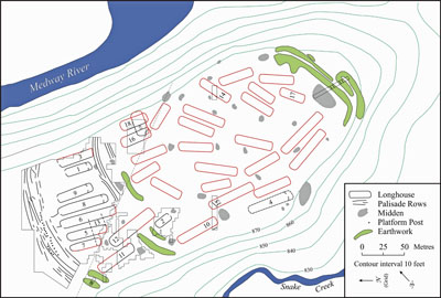
Article
The Lawson site is a two-hectare village occupied by the Neutral Iroquoians circa 1500–25 CE.
"https://d3d0lqu00lnqvz.cloudfront.net/media/media/7bb513b8-0853-4f6e-94b4-3b07c5a48729.jpg" // resources/views/front/categories/view.blade.phphttps://d3d0lqu00lnqvz.cloudfront.net/media/media/7bb513b8-0853-4f6e-94b4-3b07c5a48729.jpg
Article
The Lachine Canal passes through the southwestern part of the island of Montréal, from the Old Port to the borough of Lachine, where it flows into Lake Saint-Louis.
"https://d3d0lqu00lnqvz.cloudfront.net/media/media/3cff11c1-33f8-46e7-a459-1dcfb3bd09e1.jpg" // resources/views/front/categories/view.blade.phphttps://d3d0lqu00lnqvz.cloudfront.net/media/media/3cff11c1-33f8-46e7-a459-1dcfb3bd09e1.jpg

Article
Château Ramezay, in Old Montréal, was the first building to be designated a historic monument by the government of Québec, in 1929. Recognized as a National Historic Site of Canada in 1949, it is now a museum with permanent collections and temporary exhibits where visitors can learn about over 500 years of Montréal’s history.
"https://d3d0lqu00lnqvz.cloudfront.net/media/media/0e53d9e8-0dcd-402a-ae45-4a6207d2455e.jpg" // resources/views/front/categories/view.blade.phphttps://d3d0lqu00lnqvz.cloudfront.net/media/media/0e53d9e8-0dcd-402a-ae45-4a6207d2455e.jpg
Article
Leitch Collieries, an Alberta provincial HISTORIC SITE, is located near the entrance to the municipality of CROWSNEST PASS. This mine site is now abandoned, but in 1907, when it opened, it was considered one of the most advanced and up-to-date coal and coke operations in Canada.
"https://www.thecanadianencyclopedia.ca/images/tce_placeholder.jpg?v=e9dca980c9bdb3aa11e832e7ea94f5d9" // resources/views/front/categories/view.blade.phphttps://www.thecanadianencyclopedia.ca/images/tce_placeholder.jpg?v=e9dca980c9bdb3aa11e832e7ea94f5d9
Article
These English-style gardens have been a national historic site of Canada since 1995. They cover an area of 18 hectares and are located in the Grand-Métis municipality of Québec, at the entrance to the Gaspé Peninsula.
"https://d3d0lqu00lnqvz.cloudfront.net/media/media/b121f5aa-bf90-422c-96f8-87c9ab1fb2c4.jpg" // resources/views/front/categories/view.blade.phphttps://d3d0lqu00lnqvz.cloudfront.net/media/media/b121f5aa-bf90-422c-96f8-87c9ab1fb2c4.jpg

Article
The Library of Parliament came into being when the legislative libraries of Upper and Lower Canada were amalgamated in 1841 and situated in Montréal. In 1849 only 200 of the 12,000 books were saved when an angry mob protesting the Rebellion Losses Bill set fire to the Parliament Buildings.
"https://d3d0lqu00lnqvz.cloudfront.net/media/media/0a4e70e6-7f91-4f8f-8d9a-ac741765b114.jpg" // resources/views/front/categories/view.blade.phphttps://d3d0lqu00lnqvz.cloudfront.net/media/media/0a4e70e6-7f91-4f8f-8d9a-ac741765b114.jpg

Article
Linear Mounds Site, including the Linear Mounds National Historic Site of Canada, is located on the plain overlooking the Souris River in southwestern Manitoba.
"https://d3d0lqu00lnqvz.cloudfront.net/media/media/69b4fffb-a883-442d-beeb-f533063ac2a4.jpg" // resources/views/front/categories/view.blade.phphttps://d3d0lqu00lnqvz.cloudfront.net/media/media/69b4fffb-a883-442d-beeb-f533063ac2a4.jpg

Article
In the 18th century, Louisbourg was a fortified town and an important strategic capital in the French colony of Île Royale (Cape Breton Island). It was the scene of two major military sieges in the Anglo-French wars for supremacy in North America. The fall of Louisbourg to the British in 1758 paved the way for the capture of Québec and the end of French rule in North America. Today, Louisbourg is a national historic site and a popular tourist destination in Cape Breton.
"https://d3d0lqu00lnqvz.cloudfront.net/media/media/5a0c0b6b-1a28-4955-ac10-111582958476.jpg" // resources/views/front/categories/view.blade.phphttps://d3d0lqu00lnqvz.cloudfront.net/media/media/5a0c0b6b-1a28-4955-ac10-111582958476.jpg

Article
Lower Fort Garry was built 30 km down the Red River from Fort Garry [Winnipeg] during the 1830s as the Hudson's Bay Company's administrative centre for Rupert's Land. Although it never achieved the status originally intended, Lower Fort Garry served in a number of minor roles.
"https://d3d0lqu00lnqvz.cloudfront.net/media/media/ce49e37a-797d-412f-99cc-c169fa823dc9.jpg" // resources/views/front/categories/view.blade.phphttps://d3d0lqu00lnqvz.cloudfront.net/media/media/ce49e37a-797d-412f-99cc-c169fa823dc9.jpg

Article
This provincial farm is a HISTORIC SITE located in the MIRAMICHI region of New Brunswick near Bartibog. The farm was founded by Alexander MacDonald, a Scot who had come to North America as a soldier during the AMERICAN REVOLUTION.
"https://www.thecanadianencyclopedia.ca/images/tce_placeholder.jpg?v=e9dca980c9bdb3aa11e832e7ea94f5d9" // resources/views/front/categories/view.blade.phphttps://www.thecanadianencyclopedia.ca/images/tce_placeholder.jpg?v=e9dca980c9bdb3aa11e832e7ea94f5d9
Article
Madawaska was a borderland that comprised parts of New Brunswick, Lower Canada, and the state of Maine, concentrated along the upper Saint John River valley.
"https://d3d0lqu00lnqvz.cloudfront.net/media/media/0052e055-bf0b-4980-8f10-08f926f15b9b.jpg" // resources/views/front/categories/view.blade.phphttps://d3d0lqu00lnqvz.cloudfront.net/media/media/0052e055-bf0b-4980-8f10-08f926f15b9b.jpg
